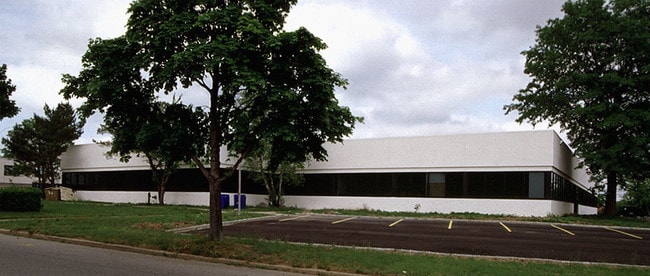
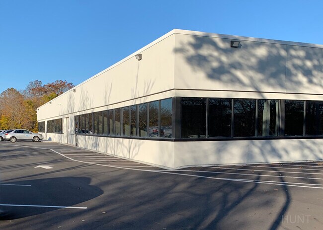
Property Record
51 E Bethpage Rd, Plainview, NY 11803


Property Detail
51 E Bethpage Rd
Nassau County-Suffolk County, NY
TOWN #3 SCH DIST 019
2489-13-088-00-0036-0
Nassau
Officebuilding
New York
B and X Area of moderate flood hazard, usually the area between the limits of the 100-year and 500-year floods.
36
2025
1.94 AC
2025
Eastern Nassau
519702
Long Island (New York)
25,460 SF
NEARBY LISTINGS FOR SALE OR LEASE
DEMOGRAPHICS near 51 E Bethpage Rd
1 mile
3 mile
5 mile
2025 Total Population
10,183
80,218
257,001
2030 Population
10,348
80,680
256,625
Pop Growth 2025-2030
+ 1.62%
+ 0.58%
(0.15%)
Average Age
47
44
43
2025 Total Households
3,763
27,226
84,023
HH Growth 2025-2030
+ 1.62%
+ 0.47%
(0.22%)
Median Household Inc
$190,582
$167,121
$151,202
Avg Household Size
2.60
2.80
2.90
2025 Avg HH Vehicles
2.00
2.00
2.00
Median Home Value
$859,010
$774,408
$741,398
Median Year Built
1965
1958
1957
Nearby Places
Map Layers
Map Styles
 Street
 Aerial
Transit
 Traffic
 Biking
Places
Listings with unknown addresses are not visible on the map
- Restaurants
- Banks
- Shops
- Fitness
- Groceries
PUBLIC TRANSPORTATION
COMMUTER RAIL
Bethpage Station (Ronkonkoma Branch - Long Island Rail Road)
Drive
Walk
Distance
Bethpage Station (Ronkonkoma Branch - Long Island Rail Road)
9 min
3.7 mi
Cold Spring Harbor Station (Port Jefferson Branch - Long Island Rail Road)
Drive
Walk
Distance
Cold Spring Harbor Station (Port Jefferson Branch - Long Island Rail Road)
10 min
4.4 mi
AIRPORT
Long Island MacArthur
Drive
Walk
Distance
Long Island MacArthur
32 min
20.4 mi
John F Kennedy International
Drive
Walk
Distance
John F Kennedy International
39 min
26.7 mi
LaGuardia
Drive
Walk
Distance
LaGuardia
41 min
26.9 mi
Freight Ports
NY - Red Hook Container Terminal
Drive
Walk
Distance
NY - Red Hook Container Terminal
52 min
35.0 mi
SALE & LEASE HISTORY
LISTING DATE
SALE/LEASE

Sep 17, 2019
For Lease
Mar 05, 2019
For Sale
Nearby Properties
Address
Land Use
TOTAL SIZE
Lot Size
Zoning
Address
Land Use
TOTAL SIZE
Lot Size
Zoning
Address
Land Use
TOTAL SIZE
Lot Size
Zoning
Address
Land Use
TOTAL SIZE
Lot Size
Zoning
Address
Land Use
TOTAL SIZE
Lot Size
Zoning
37 AC
I2
Address
Land Use
TOTAL SIZE
Lot Size
Zoning
116,514 SF
382 AC
Address
Land Use
TOTAL SIZE
Lot Size
Zoning
35,978 SF
375.68 AC
Address
Land Use
TOTAL SIZE
Lot Size
Zoning
6.30 AC
Address
Land Use
TOTAL SIZE
Lot Size
Zoning
16,520 SF
160.33 AC
Address
Land Use
TOTAL SIZE
Lot Size
Zoning
1,945 SF
278.09 AC
Address
Land Use
TOTAL SIZE
Lot Size
Zoning
Address
Land Use
TOTAL SIZE
Lot Size
Zoning
1,003,826 SF
84.27 AC
Address
Land Use
TOTAL SIZE
Lot Size
Zoning
33.80 AC
Address
Land Use
TOTAL SIZE
Lot Size
Zoning
647,177 SF
51.88 AC
Address
Land Use
TOTAL SIZE
Lot Size
Zoning
15,825 SF
22.94 AC
Address
Land Use
TOTAL SIZE
Lot Size
Zoning
288 SF
194.85 AC
Address
Land Use
TOTAL SIZE
Lot Size
Zoning
659,098 SF
34.76 AC
Address
Land Use
TOTAL SIZE
Lot Size
Zoning
3,951 SF
44.33 AC
Address
Land Use
TOTAL SIZE
Lot Size
Zoning
Address
Land Use
TOTAL SIZE
Lot Size
Zoning
52.10 AC
Address
Land Use
TOTAL SIZE
Lot Size
Zoning
52,750 SF
55.67 AC
Address
Land Use
TOTAL SIZE
Lot Size
Zoning
37.20 AC
I2
Address
Land Use
TOTAL SIZE
Lot Size
Zoning
Address
Land Use
TOTAL SIZE
Lot Size
Zoning
Address
Land Use
TOTAL SIZE
Lot Size
Zoning
24.75 AC
R40
Address
Land Use
TOTAL SIZE
Lot Size
Zoning
332,290 SF
25.91 AC
Address
Land Use
TOTAL SIZE
Lot Size
Zoning
183.15 AC
Address
Land Use
TOTAL SIZE
Lot Size
Zoning
146,287 SF
48.63 AC
Address
Land Use
TOTAL SIZE
Lot Size
Zoning
77,284 SF
40.86 AC
Address
Land Use
TOTAL SIZE
Lot Size
Zoning
11.50 AC
C10
Address
Land Use
TOTAL SIZE
Lot Size
Zoning
177,845 SF
22.04 AC
The World's #1 Commercial Real Estate Marketplace
Connect with us
© 2026 CoStar Group
The information above has been obtained from sources believed reliable. While we do not doubt its accuracy we have not verified it and make no guarantee, warranty or representation about it. It is your responsibility to independently confirm its accuracy and completeness. Any projections, opinions, assumptions, or estimates used are for example only and do not represent the current or future performance of the property. The value of this transaction to you depends on tax and other factors which should be evaluated by your tax, financial, and legal advisors. You and your advisors should conduct a careful, independent investigation of the property to determine to your satisfaction the suitability of the property for your needs.