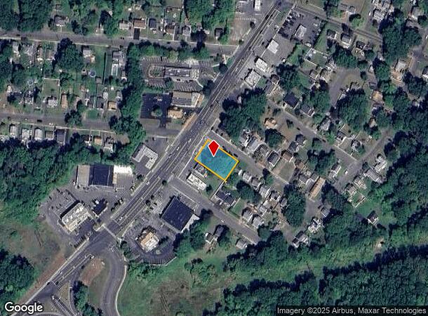
Property Record
51 Enfield St, Enfield, CT 06082
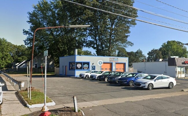
This Property Is For Sale
NEARBY LISTINGS FOR SALE OR LEASE
Property Detail
51 Enfield St
ENFI-000035-000000-000206
Hartford
Commercialbuilding
Connecticut
X
206
25013C0414E
0.35 AC
2025
Enfield
2025
Hartford
480300
Hartford-West Hartford-East Hartford, CT
1,305 SF
DEMOGRAPHICS near 51 Enfield St
1 Mile
3 Mile
5 Mile
2024 Total Population
5,330
41,019
113,930
2029 Population
5,283
40,623
112,495
Pop Growth 2024-2029
(0.88%)
(0.97%)
(1.26%)
Average Age
42
42
41
2024 Total Households
2,129
16,037
42,860
HH Growth 2024-2029
(0.94%)
(1.12%)
(1.45%)
Median Household Inc
$90,915
$93,038
$79,983
Avg Household Size
2.50
2.40
2.40
2024 Avg HH Vehicles
2.00
2.00
2.00
Median Home Value
$226,110
$278,441
$267,871
Median Year Built
1955
1959
1958
Nearby Places
Map Layers
Map Styles
 Street
 Aerial
- Restaurants
- Banks
- Shops
- Fitness
- Groceries
PUBLIC TRANSPORTATION
COMMUTER RAIL
Springfield (Amtrak Hartford Line - Amtrak, Hartford Line - Amtrak, Lake Shore Limited - Amtrak, Northeast Regional - Amtrak, Valley Flyer - Amtrak, Vermonter - Amtrak)
DRIVE
WALK
Distance
Springfield (Amtrak Hartford Line - Amtrak, Hartford Line - Amtrak, Lake Shore Limited - Amtrak, Northeast Regional - Amtrak, Valley Flyer - Amtrak, Vermonter - Amtrak)
10 min
7.0 mi
Windsor Locks (Hartford Line - CT Rail (CTRail))
DRIVE
WALK
Distance
Windsor Locks (Hartford Line - CT Rail (CTRail))
12 min
9.4 mi
AIRPORT
Bradley International
DRIVE
WALK
Distance
Bradley International
24 min
10.2 mi
Freight Ports
Port of New Haven
DRIVE
WALK
Distance
Port of New Haven
75 min
58.9 mi
Nearby Properties
Address
Land Use
TOTAL SIZE
Lot Size
Zoning
Address
Land Use
TOTAL SIZE
Lot Size
Zoning
236,616 SF
31.07 AC
RA1
Address
Land Use
TOTAL SIZE
Lot Size
Zoning
69.62 AC
MFHD
Address
Land Use
TOTAL SIZE
Lot Size
Zoning
166,268 SF
36.70 AC
R44
Address
Land Use
TOTAL SIZE
Lot Size
Zoning
8,712 SF
25.08 AC
RA1
Address
Land Use
TOTAL SIZE
Lot Size
Zoning
9.69 AC
B
Address
Land Use
TOTAL SIZE
Lot Size
Zoning
1,840 SF
148.78 AC
BB
Address
Land Use
TOTAL SIZE
Lot Size
Zoning
500,000 SF
71.20 AC
I-1
Address
Land Use
TOTAL SIZE
Lot Size
Zoning
121.07 AC
I-1
Address
Land Use
TOTAL SIZE
Lot Size
Zoning
32.97 AC
BR
Address
Land Use
TOTAL SIZE
Lot Size
Zoning
65.52 AC
BR
Address
Land Use
TOTAL SIZE
Lot Size
Zoning
24.27 AC
SDD
Address
Land Use
TOTAL SIZE
Lot Size
Zoning
32.44 AC
BR
Address
Land Use
TOTAL SIZE
Lot Size
Zoning
319,054 SF
30.02 AC
I-P
Address
Land Use
TOTAL SIZE
Lot Size
Zoning
211,256 SF
41.58 AC
R33
Address
Land Use
TOTAL SIZE
Lot Size
Zoning
24.92 AC
BL
Address
Land Use
TOTAL SIZE
Lot Size
Zoning
13.87 AC
BR
Address
Land Use
TOTAL SIZE
Lot Size
Zoning
103,324 SF
20.47 AC
RA1
Address
Land Use
TOTAL SIZE
Lot Size
Zoning
13.78 AC
BR
Address
Land Use
TOTAL SIZE
Lot Size
Zoning
1.87 AC
BP
Address
Land Use
TOTAL SIZE
Lot Size
Zoning
19.36 AC
BR
Address
Land Use
TOTAL SIZE
Lot Size
Zoning
144,625 SF
19 AC
BR
Address
Land Use
TOTAL SIZE
Lot Size
Zoning
11.51 AC
RA1
Address
Land Use
TOTAL SIZE
Lot Size
Zoning
23,660 SF
9.28 AC
RA1
Address
Land Use
TOTAL SIZE
Lot Size
Zoning
17.34 AC
R44
Address
Land Use
TOTAL SIZE
Lot Size
Zoning
3.59 AC
B
Address
Land Use
TOTAL SIZE
Lot Size
Zoning
91,735 SF
9.28 AC
RA1
Address
Land Use
TOTAL SIZE
Lot Size
Zoning
72,832 SF
10 AC
RA1
Address
Land Use
TOTAL SIZE
Lot Size
Zoning
83,699 SF
16.05 AC
RA1
Address
Land Use
TOTAL SIZE
Lot Size
Zoning
54.05 AC
I-1
Address
Land Use
TOTAL SIZE
Lot Size
Zoning
220.65 AC
RA1
The World's #1 Commercial Real Estate Marketplace
Connect with us
© 2026 CoStar Group
The information above has been obtained from sources believed reliable. While we do not doubt its accuracy we have not verified it and make no guarantee, warranty or representation about it. It is your responsibility to independently confirm its accuracy and completeness. Any projections, opinions, assumptions, or estimates used are for example only and do not represent the current or future performance of the property. The value of this transaction to you depends on tax and other factors which should be evaluated by your tax, financial, and legal advisors. You and your advisors should conduct a careful, independent investigation of the property to determine to your satisfaction the suitability of the property for your needs.