Property Record
51 Maple St, Afton, NY 13730


NEARBY LISTINGS FOR SALE OR LEASE
-
-
View all Afton listings for sale on LoopNet.com
Property Detail
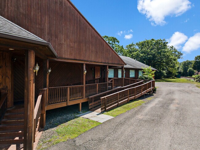
51 Maple St
Restaurantbuilding
Chenango
AE
New York
36017C0582E
1.220
2025
1.80 AC
2024
New York Southeast Area
970902
Other Market Areas
5,000 SF
082001-289-110-0001-001-220-0000
DEMOGRAPHICS near 51 Maple St
1 Mile
3 Mile
5 Mile
2024 Total Population
956
2,135
4,429
2029 Population
941
2,119
4,400
Pop Growth 2024-2029
(1.57%)
(0.75%)
(0.65%)
Average Age
44
44
44
2024 Total Households
404
910
1,891
HH Growth 2024-2029
(1.73%)
(0.77%)
(0.69%)
Median Household Inc
$71,186
$61,860
$60,667
Avg Household Size
2.40
2.30
2.30
2024 Avg HH Vehicles
2.00
2.00
2.00
Median Home Value
$122,973
$135,765
$138,555
Median Year Built
1972
1970
1970
Nearby Places
Map Layers
Map Styles
 Street
 Aerial
- Restaurants
- Banks
- Shops
- Fitness
- Groceries
SALE & LEASE HISTORY
LISTING DATE
SALE/LEASE

Mar 23, 2022
For Sale
Nearby Properties
Address
Land Use
TOTAL SIZE
Lot Size
Zoning
Address
Land Use
TOTAL SIZE
Lot Size
Zoning
17.80 AC
Address
Land Use
TOTAL SIZE
Lot Size
Zoning
Address
Land Use
TOTAL SIZE
Lot Size
Zoning
3.01 AC
Address
Land Use
TOTAL SIZE
Lot Size
Zoning
0.96 AC
Address
Land Use
TOTAL SIZE
Lot Size
Zoning
4,512 SF
17.77 AC
03 - MULTI
Address
Land Use
TOTAL SIZE
Lot Size
Zoning
22.70 AC
Address
Land Use
TOTAL SIZE
Lot Size
Zoning
37.61 AC
Address
Land Use
TOTAL SIZE
Lot Size
Zoning
1.50 AC
Address
Land Use
TOTAL SIZE
Lot Size
Zoning
8,800 SF
5 AC
03 - MULTI
Address
Land Use
TOTAL SIZE
Lot Size
Zoning
0.30 AC
Address
Land Use
TOTAL SIZE
Lot Size
Zoning
Address
Land Use
TOTAL SIZE
Lot Size
Zoning
375.46 AC
03 - MULTI
Address
Land Use
TOTAL SIZE
Lot Size
Zoning
106.52 AC
Address
Land Use
TOTAL SIZE
Lot Size
Zoning
52.40 AC
Address
Land Use
TOTAL SIZE
Lot Size
Zoning
279 SF
0.26 AC
Address
Land Use
TOTAL SIZE
Lot Size
Zoning
03 - MULTI
Address
Land Use
TOTAL SIZE
Lot Size
Zoning
6,864 SF
3.47 AC
03 - MULTI
Address
Land Use
TOTAL SIZE
Lot Size
Zoning
8,280 SF
6 AC
03 - MULTI
Address
Land Use
TOTAL SIZE
Lot Size
Zoning
03 - MULTI
Address
Land Use
TOTAL SIZE
Lot Size
Zoning
180 SF
1.26 AC
Address
Land Use
TOTAL SIZE
Lot Size
Zoning
2.80 AC
Address
Land Use
TOTAL SIZE
Lot Size
Zoning
3,712 SF
1.42 AC
Address
Land Use
TOTAL SIZE
Lot Size
Zoning
166 AC
03 - MULTI
Address
Land Use
TOTAL SIZE
Lot Size
Zoning
1,560 SF
2.48 AC
Address
Land Use
TOTAL SIZE
Lot Size
Zoning
2,048 SF
0.26 AC
03 - MULTI
Address
Land Use
TOTAL SIZE
Lot Size
Zoning
0.67 AC
Address
Land Use
TOTAL SIZE
Lot Size
Zoning
792 SF
3.80 AC
03 - MULTI
Address
Land Use
TOTAL SIZE
Lot Size
Zoning
221.61 AC
Address
Land Use
TOTAL SIZE
Lot Size
Zoning
0.58 AC
The World's #1 Commercial Real Estate Marketplace
Connect with us
© 2025 CoStar Group
The information above has been obtained from sources believed reliable. While we do not doubt its accuracy we have not verified it and make no guarantee, warranty or representation about it. It is your responsibility to independently confirm its accuracy and completeness. Any projections, opinions, assumptions, or estimates used are for example only and do not represent the current or future performance of the property. The value of this transaction to you depends on tax and other factors which should be evaluated by your tax, financial, and legal advisors. You and your advisors should conduct a careful, independent investigation of the property to determine to your satisfaction the suitability of the property for your needs.