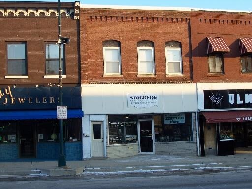
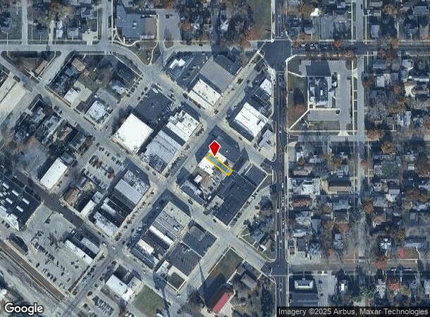
Property Record
51 N Ayer St, Harvard, IL 60033
NEARBY LISTINGS FOR SALE OR LEASE
-
-
View all Harvard listings for sale on LoopNet.com
Property Detail
51 N Ayer St
Chicago-Naperville-Elgin, IL-IN
Orig Plat City Of Harvard
01-35-411-003
DOC 2022R0013322 & 2008R0056287 LT 4 BLK 5 ORIG PLAT CITY OF HARVARD MEMO: AGUILAR, FAMILY TR/MARQUEZ, MARIBEL
Commercialnec
McHenry
X
Illinois
55127C0450D
4
2024
0.06 AC
2024
Far Northwest
870302
Chicago
DEMOGRAPHICS near 51 N Ayer St
1 mile
3 mile
5 mile
2024 Total Population
8,294
11,011
12,529
2029 Population
8,326
11,026
12,529
Pop Growth 2024-2029
+ 0.39%
+ 0.14%
0.00%
Average Age
36
37
38
2024 Total Households
2,783
3,760
4,354
HH Growth 2024-2029
+ 0.40%
+ 0.13%
(0.02%)
Median Household Inc
$62,819
$64,983
$66,678
Avg Household Size
2.90
2.90
2.80
2024 Avg HH Vehicles
2.00
2.00
2.00
Median Home Value
$155,170
$162,850
$172,478
Median Year Built
1976
1980
1979
Nearby Places
Map Layers
Map Styles
 Street
 Aerial
Transit
 Traffic
 Biking
Places
Listings with unknown addresses are not visible on the map
- Restaurants
- Banks
- Shops
- Fitness
- Groceries
PUBLIC TRANSPORTATION
COMMUTER RAIL
Harvard Station (Union Pacific Northwest Line - Northeast Illinois Regional Commuter Railroad (Metra))
Drive
Walk
Distance
Harvard Station (Union Pacific Northwest Line - Northeast Illinois Regional Commuter Railroad (Metra))
1 min
5 min
0.3 mi
AIRPORT
Chicago/Rockford International
Drive
Walk
Distance
Chicago/Rockford International
58 min
41.0 mi
Freight Ports
Port Milwaukee
Drive
Walk
Distance
Port Milwaukee
82 min
63.8 mi
Nearby Properties
Address
Land Use
TOTAL SIZE
Lot Size
Zoning
Address
Land Use
TOTAL SIZE
Lot Size
Zoning
23.89 AC
Address
Land Use
TOTAL SIZE
Lot Size
Zoning
290.30 AC
Address
Land Use
TOTAL SIZE
Lot Size
Zoning
150,352 SF
16.65 AC
Address
Land Use
TOTAL SIZE
Lot Size
Zoning
457,340 SF
19.04 AC
Address
Land Use
TOTAL SIZE
Lot Size
Zoning
8.38 AC
Address
Land Use
TOTAL SIZE
Lot Size
Zoning
4.34 AC
Address
Land Use
TOTAL SIZE
Lot Size
Zoning
6.51 AC
Address
Land Use
TOTAL SIZE
Lot Size
Zoning
346,000 SF
11.50 AC
Address
Land Use
TOTAL SIZE
Lot Size
Zoning
17.16 AC
Address
Land Use
TOTAL SIZE
Lot Size
Zoning
5.89 AC
Address
Land Use
TOTAL SIZE
Lot Size
Zoning
209,100 SF
8.04 AC
Address
Land Use
TOTAL SIZE
Lot Size
Zoning
292,500 SF
17.66 AC
Address
Land Use
TOTAL SIZE
Lot Size
Zoning
Address
Land Use
TOTAL SIZE
Lot Size
Zoning
3.44 AC
Address
Land Use
TOTAL SIZE
Lot Size
Zoning
25,475 SF
2.69 AC
Address
Land Use
TOTAL SIZE
Lot Size
Zoning
3.16 AC
Address
Land Use
TOTAL SIZE
Lot Size
Zoning
3.74 AC
Address
Land Use
TOTAL SIZE
Lot Size
Zoning
7,232 SF
2.15 AC
Address
Land Use
TOTAL SIZE
Lot Size
Zoning
Address
Land Use
TOTAL SIZE
Lot Size
Zoning
45,771 SF
5.90 AC
Address
Land Use
TOTAL SIZE
Lot Size
Zoning
52,107 SF
5.03 AC
Address
Land Use
TOTAL SIZE
Lot Size
Zoning
2.23 AC
Address
Land Use
TOTAL SIZE
Lot Size
Zoning
1.31 AC
Address
Land Use
TOTAL SIZE
Lot Size
Zoning
13,619 SF
1.66 AC
Address
Land Use
TOTAL SIZE
Lot Size
Zoning
15,750 SF
1.60 AC
Address
Land Use
TOTAL SIZE
Lot Size
Zoning
29,076 SF
1.75 AC
Address
Land Use
TOTAL SIZE
Lot Size
Zoning
0.98 AC
Address
Land Use
TOTAL SIZE
Lot Size
Zoning
0.49 AC
Address
Land Use
TOTAL SIZE
Lot Size
Zoning
20,434 SF
0.65 AC
Address
Land Use
TOTAL SIZE
Lot Size
Zoning
The World's #1 Commercial Real Estate Marketplace
Connect with us
© 2026 CoStar Group
The information above has been obtained from sources believed reliable. While we do not doubt its accuracy we have not verified it and make no guarantee, warranty or representation about it. It is your responsibility to independently confirm its accuracy and completeness. Any projections, opinions, assumptions, or estimates used are for example only and do not represent the current or future performance of the property. The value of this transaction to you depends on tax and other factors which should be evaluated by your tax, financial, and legal advisors. You and your advisors should conduct a careful, independent investigation of the property to determine to your satisfaction the suitability of the property for your needs.