Property Record
51 Parksville Rd, Liberty, NY 12754
NEARBY LISTINGS FOR SALE OR LEASE
Property Detail
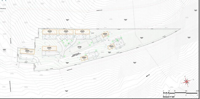
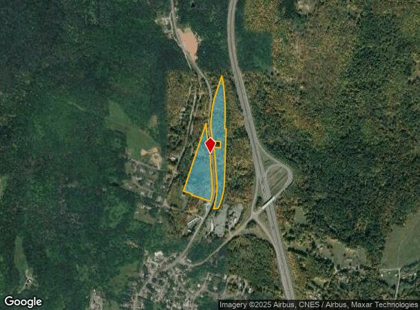
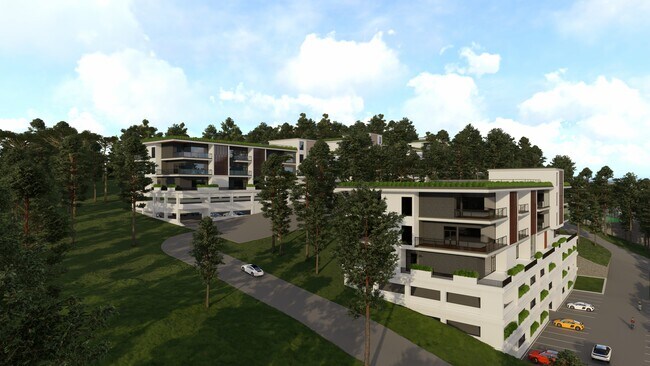
51 Parksville Rd
3689-018-0-0001-032-000
Sullivan
Residentialacreage
New York
X
32.000
36105C0303F
13.57 AC
2025
Hudson Valley Area
2024
Other Market Areas
950701
DEMOGRAPHICS near 51 Parksville Rd
1 Mile
3 Mile
5 Mile
2024 Total Population
1,694
7,254
11,281
2029 Population
1,733
7,484
11,579
Pop Growth 2024-2029
+ 2.30%
+ 3.17%
+ 2.64%
Average Age
41
40
41
2024 Total Households
680
2,745
4,304
HH Growth 2024-2029
+ 2.65%
+ 3.42%
+ 2.93%
Median Household Inc
$43,888
$45,349
$45,763
Avg Household Size
2.40
2.50
2.50
2024 Avg HH Vehicles
1.00
1.00
2.00
Median Home Value
$125,172
$145,839
$163,083
Median Year Built
1955
1959
1966
Nearby Places
- Restaurants
- Banks
- Shops
- Fitness
- Groceries
SALE & LEASE HISTORY
LISTING DATE
SALE/LEASE

Mar 28, 2017
For Sale
Feb 28, 2023
For Sale
Aug 13, 2020
For Sale
Apr 05, 2022
For Sale
Nearby Properties
Address
Land Use
TOTAL SIZE
Lot Size
Zoning
Address
Land Use
TOTAL SIZE
Lot Size
Zoning
98,138 SF
47.80 AC
C
Address
Land Use
TOTAL SIZE
Lot Size
Zoning
58,488 SF
50 AC
C
Address
Land Use
TOTAL SIZE
Lot Size
Zoning
16,872 SF
67 AC
C
Address
Land Use
TOTAL SIZE
Lot Size
Zoning
127,937 SF
12.41 AC
C
Address
Land Use
TOTAL SIZE
Lot Size
Zoning
6,832 SF
31.50 AC
RD
Address
Land Use
TOTAL SIZE
Lot Size
Zoning
108,721 SF
3.93 AC
M
Address
Land Use
TOTAL SIZE
Lot Size
Zoning
21,288 SF
43.34 AC
RD2
Address
Land Use
TOTAL SIZE
Lot Size
Zoning
58,675 SF
6.46 AC
C
Address
Land Use
TOTAL SIZE
Lot Size
Zoning
1,042,540 SF
14.62 AC
C
Address
Land Use
TOTAL SIZE
Lot Size
Zoning
21,600 SF
7.10 AC
SC
Address
Land Use
TOTAL SIZE
Lot Size
Zoning
8,080 SF
7.07 AC
C
Address
Land Use
TOTAL SIZE
Lot Size
Zoning
20,777 SF
118.90 AC
RD2
Address
Land Use
TOTAL SIZE
Lot Size
Zoning
3,196 SF
80.90 AC
RD2
Address
Land Use
TOTAL SIZE
Lot Size
Zoning
14,658 SF
5.67 AC
M
Address
Land Use
TOTAL SIZE
Lot Size
Zoning
4,230 SF
59.74 AC
C
Address
Land Use
TOTAL SIZE
Lot Size
Zoning
26,884 SF
100.72 AC
RD2
Address
Land Use
TOTAL SIZE
Lot Size
Zoning
5,996 SF
35.47 AC
C
Address
Land Use
TOTAL SIZE
Lot Size
Zoning
65,628 SF
2.70 AC
C
Address
Land Use
TOTAL SIZE
Lot Size
Zoning
15,401 SF
62.56 AC
SC
Address
Land Use
TOTAL SIZE
Lot Size
Zoning
20,816 SF
1.90 AC
C
Address
Land Use
TOTAL SIZE
Lot Size
Zoning
16,176 SF
20.16 AC
RD
Address
Land Use
TOTAL SIZE
Lot Size
Zoning
23,768 SF
2.24 AC
C
Address
Land Use
TOTAL SIZE
Lot Size
Zoning
6,048 SF
105.58 AC
RD2
Address
Land Use
TOTAL SIZE
Lot Size
Zoning
2,131 SF
93.10 AC
RD2
Address
Land Use
TOTAL SIZE
Lot Size
Zoning
18,472 SF
1.33 AC
C
Address
Land Use
TOTAL SIZE
Lot Size
Zoning
42,371 SF
1.20 AC
C
Address
Land Use
TOTAL SIZE
Lot Size
Zoning
15,068 SF
8.41 AC
C
Address
Land Use
TOTAL SIZE
Lot Size
Zoning
22,338 SF
3 AC
C
Address
Land Use
TOTAL SIZE
Lot Size
Zoning
11,627 SF
1.95 AC
M
Address
Land Use
TOTAL SIZE
Lot Size
Zoning
11,260 SF
70 AC
AC
The World's #1 Commercial Real Estate Marketplace
Connect with us
© 2025 CoStar Group
The information above has been obtained from sources believed reliable. While we do not doubt its accuracy we have not verified it and make no guarantee, warranty or representation about it. It is your responsibility to independently confirm its accuracy and completeness. Any projections, opinions, assumptions, or estimates used are for example only and do not represent the current or future performance of the property. The value of this transaction to you depends on tax and other factors which should be evaluated by your tax, financial, and legal advisors. You and your advisors should conduct a careful, independent investigation of the property to determine to your satisfaction the suitability of the property for your needs.