Property Record
51 Proctor Rd, Thomasville, NC 27360
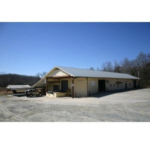
Property Detail
51 Proctor Rd
16-309-0-000-0062-0-0-0
L62 BK1841-150 MYERS-PROCTOR
Manufacturinglight
Davidson
RA3
North Carolina
AE The base floodplain where base flood elevations are provided. AE Zones are now used on new format FIRMs instead of A1-A30 Zones.
4.69 AC
2025
North Davidson County
2025
Greensboro/Winston-Salem
060601
Winston-Salem, NC
15,844 SF
NEARBY LISTINGS FOR SALE OR LEASE
DEMOGRAPHICS near 51 Proctor Rd
1 mile
3 mile
5 mile
2025 Total Population
784
17,667
61,369
2030 Population
811
18,408
64,215
Pop Growth 2025-2030
+ 3.44%
+ 4.19%
+ 4.64%
Average Age
40
40
40
2025 Total Households
280
6,815
24,651
HH Growth 2025-2030
+ 3.21%
+ 4.30%
+ 4.74%
Median Household Inc
$85,399
$71,548
$63,431
Avg Household Size
2.80
2.50
2.40
2025 Avg HH Vehicles
2.00
2.00
2.00
Median Home Value
$273,038
$244,847
$230,309
Median Year Built
1991
1983
1976
Nearby Places
Map Layers
Map Styles
 Street
 Aerial
Layers
 Traffic
 Biking
Places
Listings with unknown addresses are not visible on the map
- Restaurants
- Banks
- Shops
- Fitness
- Groceries
PUBLIC TRANSPORTATION
COMMUTER RAIL
High Point Station (Piedmont - North Carolina by Train (NC Train))
Drive
Walk
Distance
High Point Station (Piedmont - North Carolina by Train (NC Train))
15 min
5.9 mi
AIRPORT
Piedmont Triad International
Drive
Walk
Distance
Piedmont Triad International
40 min
17.3 mi
Nearby Properties
Address
Land Use
TOTAL SIZE
Lot Size
Zoning
Address
Land Use
TOTAL SIZE
Lot Size
Zoning
13,770 SF
34.64 AC
R10
Address
Land Use
TOTAL SIZE
Lot Size
Zoning
111,312 SF
7.98 AC
RM-26
Address
Land Use
TOTAL SIZE
Lot Size
Zoning
63,936 SF
19.05 AC
R10
Address
Land Use
TOTAL SIZE
Lot Size
Zoning
28,210 SF
49.32 AC
RS
Address
Land Use
TOTAL SIZE
Lot Size
Zoning
7,480 SF
18.55 AC
RA3
Address
Land Use
TOTAL SIZE
Lot Size
Zoning
82,160 SF
23.62 AC
C2
Address
Land Use
TOTAL SIZE
Lot Size
Zoning
121,473 SF
32.77 AC
RM-16
Address
Land Use
TOTAL SIZE
Lot Size
Zoning
57,885 SF
24.14 AC
RA3
Address
Land Use
TOTAL SIZE
Lot Size
Zoning
4,560 SF
187.84 AC
R10
Address
Land Use
TOTAL SIZE
Lot Size
Zoning
43,000 SF
15.06 AC
HI
Address
Land Use
TOTAL SIZE
Lot Size
Zoning
6,960 SF
9.61 AC
R8
Address
Land Use
TOTAL SIZE
Lot Size
Zoning
38,896 SF
6.64 AC
C2
Address
Land Use
TOTAL SIZE
Lot Size
Zoning
35,132 SF
14.36 AC
R10
Address
Land Use
TOTAL SIZE
Lot Size
Zoning
63,730 SF
19.47 AC
R10
Address
Land Use
TOTAL SIZE
Lot Size
Zoning
2,460 SF
26.64 AC
R8
Address
Land Use
TOTAL SIZE
Lot Size
Zoning
1,551 SF
16.15 AC
R8
Address
Land Use
TOTAL SIZE
Lot Size
Zoning
13,891 SF
63.54 AC
RA3
Address
Land Use
TOTAL SIZE
Lot Size
Zoning
31,332 SF
7.89 AC
C2
Address
Land Use
TOTAL SIZE
Lot Size
Zoning
8,400 SF
5.31 AC
C2
Address
Land Use
TOTAL SIZE
Lot Size
Zoning
85,973 SF
7.71 AC
C2
Address
Land Use
TOTAL SIZE
Lot Size
Zoning
109,440 SF
49.96 AC
M1
Address
Land Use
TOTAL SIZE
Lot Size
Zoning
19,440 SF
137.53 AC
HICZ
Address
Land Use
TOTAL SIZE
Lot Size
Zoning
50,288 SF
11.15 AC
OI
Address
Land Use
TOTAL SIZE
Lot Size
Zoning
23,865 SF
10.32 AC
RA3
Address
Land Use
TOTAL SIZE
Lot Size
Zoning
65,447 SF
21.46 AC
M1
Address
Land Use
TOTAL SIZE
Lot Size
Zoning
172,595 SF
21.18 AC
HI
Address
Land Use
TOTAL SIZE
Lot Size
Zoning
119,920 SF
6.99 AC
HI
Address
Land Use
TOTAL SIZE
Lot Size
Zoning
100,190 SF
6.82 AC
HI
Address
Land Use
TOTAL SIZE
Lot Size
Zoning
35,816 SF
20.59 AC
M1
Address
Land Use
TOTAL SIZE
Lot Size
Zoning
17,694 SF
2.79 AC
C2
The World's #1 Commercial Real Estate Marketplace
Connect with us
© 2026 CoStar Group
The information above has been obtained from sources believed reliable. While we do not doubt its accuracy we have not verified it and make no guarantee, warranty or representation about it. It is your responsibility to independently confirm its accuracy and completeness. Any projections, opinions, assumptions, or estimates used are for example only and do not represent the current or future performance of the property. The value of this transaction to you depends on tax and other factors which should be evaluated by your tax, financial, and legal advisors. You and your advisors should conduct a careful, independent investigation of the property to determine to your satisfaction the suitability of the property for your needs.