Property Record
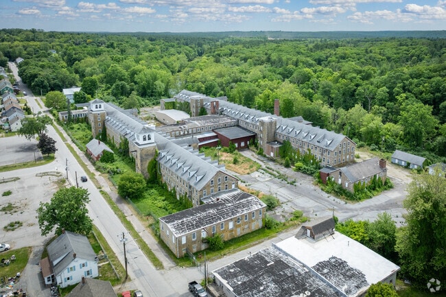
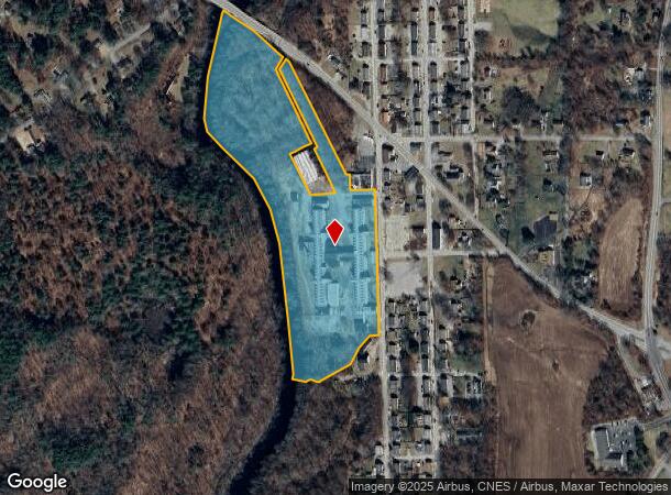
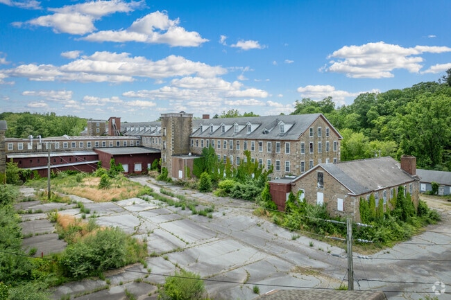
51 S Walnut St, Wauregan, CT 06387
Current Lease Availabilities
NEARBY LISTINGS FOR SALE OR LEASE
Property Detail
51 S Walnut St
PLAI-000001W-W000000M-000001
Windham
Industrialgeneral
Connecticut
AE
1
09015C0356F
23.55 AC
2024
Windham County
2025
Hartford
907100
Worcester, MA-CT
DEMOGRAPHICS near 51 S Walnut St
1 Mile
3 Mile
5 Mile
2024 Total Population
1,417
10,243
28,534
2029 Population
1,354
10,122
28,467
Pop Growth 2024-2029
(4.45%)
(1.18%)
(0.23%)
Average Age
39
40
41
2024 Total Households
521
3,949
11,146
HH Growth 2024-2029
(4.61%)
(1.14%)
(0.23%)
Median Household Inc
$86,680
$81,237
$74,733
Avg Household Size
2.60
2.50
2.40
2024 Avg HH Vehicles
2.00
2.00
2.00
Median Home Value
$235,274
$254,718
$232,340
Median Year Built
1971
1970
1968
Nearby Places
Map Layers
Map Styles
 Street
 Aerial
- Restaurants
- Banks
- Shops
- Fitness
- Groceries
PUBLIC TRANSPORTATION
AIRPORT
Rhode Island Tf Green International
DRIVE
WALK
Distance
Rhode Island Tf Green International
50 min
35.8 mi
Freight Ports
Port of Davisville, RI
DRIVE
WALK
Distance
Port of Davisville, RI
62 min
45.1 mi
Nearby Properties
Address
Land Use
TOTAL SIZE
Lot Size
Zoning
Address
Land Use
TOTAL SIZE
Lot Size
Zoning
186,583 SF
87.26 AC
RA60
Address
Land Use
TOTAL SIZE
Lot Size
Zoning
55,128 SF
5 AC
RA19
Address
Land Use
TOTAL SIZE
Lot Size
Zoning
10.29 AC
RA19
Address
Land Use
TOTAL SIZE
Lot Size
Zoning
11.29 AC
C
Address
Land Use
TOTAL SIZE
Lot Size
Zoning
139.70 AC
RA60
Address
Land Use
TOTAL SIZE
Lot Size
Zoning
96,848 SF
13.88 AC
IND-1
Address
Land Use
TOTAL SIZE
Lot Size
Zoning
11.50 AC
RA60
Address
Land Use
TOTAL SIZE
Lot Size
Zoning
233,322 SF
13.60 AC
I
Address
Land Use
TOTAL SIZE
Lot Size
Zoning
38.06 AC
Address
Land Use
TOTAL SIZE
Lot Size
Zoning
334 AC
RA60
Address
Land Use
TOTAL SIZE
Lot Size
Zoning
1,475 SF
148.80 AC
I
Address
Land Use
TOTAL SIZE
Lot Size
Zoning
1.40 AC
RA30
Address
Land Use
TOTAL SIZE
Lot Size
Zoning
5.18 AC
IND
Address
Land Use
TOTAL SIZE
Lot Size
Zoning
9,066 SF
1.20 AC
C2
Address
Land Use
TOTAL SIZE
Lot Size
Zoning
3,146 SF
9.93 AC
RA19
Address
Land Use
TOTAL SIZE
Lot Size
Zoning
9,100 SF
1.64 AC
C1
Address
Land Use
TOTAL SIZE
Lot Size
Zoning
21,582 SF
2.10 AC
GC
Address
Land Use
TOTAL SIZE
Lot Size
Zoning
21,424 SF
3.97 AC
LI
Address
Land Use
TOTAL SIZE
Lot Size
Zoning
25,000 SF
5.60 AC
IND
Address
Land Use
TOTAL SIZE
Lot Size
Zoning
6.70 AC
RA19
Address
Land Use
TOTAL SIZE
Lot Size
Zoning
Address
Land Use
TOTAL SIZE
Lot Size
Zoning
0.82 AC
C2
Address
Land Use
TOTAL SIZE
Lot Size
Zoning
18,224 SF
0.75 AC
RA19
Address
Land Use
TOTAL SIZE
Lot Size
Zoning
2.10 AC
C2
Address
Land Use
TOTAL SIZE
Lot Size
Zoning
90,915 SF
1.78 AC
IND-1
Address
Land Use
TOTAL SIZE
Lot Size
Zoning
18,238 SF
2.31 AC
RA60
Address
Land Use
TOTAL SIZE
Lot Size
Zoning
12,700 SF
4.02 AC
CI
Address
Land Use
TOTAL SIZE
Lot Size
Zoning
10 AC
RA
Address
Land Use
TOTAL SIZE
Lot Size
Zoning
17,285 SF
1.25 AC
C2
The World's #1 Commercial Real Estate Marketplace
Connect with us
© 2025 CoStar Group
The information above has been obtained from sources believed reliable. While we do not doubt its accuracy we have not verified it and make no guarantee, warranty or representation about it. It is your responsibility to independently confirm its accuracy and completeness. Any projections, opinions, assumptions, or estimates used are for example only and do not represent the current or future performance of the property. The value of this transaction to you depends on tax and other factors which should be evaluated by your tax, financial, and legal advisors. You and your advisors should conduct a careful, independent investigation of the property to determine to your satisfaction the suitability of the property for your needs.