Property Record
510 Baxter Rd, Chesterfield, MO 63017


Current Lease Availabilities
NEARBY LISTINGS FOR SALE OR LEASE
Property Detail
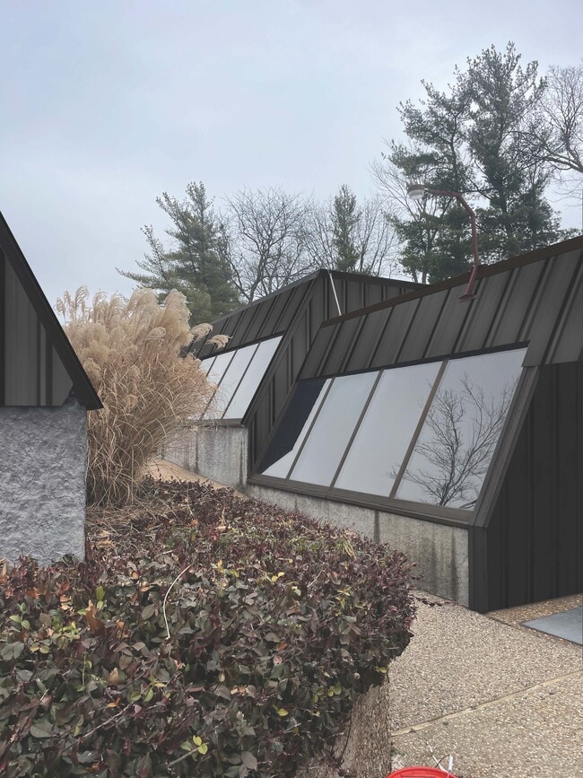
510 Baxter Rd
St. Louis, MO-IL
Baxter Estate
21R-14-0829
BAXTER ESTATE LOT PT 6 10 25 89
Officebuilding
St. Louis
X
Missouri
29099C0025F
6
2024
2.12 AC
2025
West County
217802
St. Louis
16,730 SF
DEMOGRAPHICS near 510 Baxter Rd
1 Mile
3 Mile
5 Mile
2024 Total Population
8,370
73,482
160,467
2029 Population
8,152
71,847
156,719
Pop Growth 2024-2029
(2.60%)
(2.23%)
(2.34%)
Average Age
45
43
43
2024 Total Households
3,257
28,668
62,952
HH Growth 2024-2029
(2.67%)
(2.26%)
(2.36%)
Median Household Inc
$131,352
$114,933
$114,666
Avg Household Size
2.50
2.50
2.50
2024 Avg HH Vehicles
2.00
2.00
2.00
Median Home Value
$350,349
$349,592
$368,633
Median Year Built
1971
1976
1980
Nearby Places
Map Layers
Map Styles
 Street
 Aerial
- Restaurants
- Banks
- Shops
- Fitness
- Groceries
PUBLIC TRANSPORTATION
COMMUTER RAIL
Kirkwood Amtrak Station (Lincoln Service Missouri River Runner - Amtrak, Missouri River Runner - Amtrak)
DRIVE
WALK
Distance
Kirkwood Amtrak Station (Lincoln Service Missouri River Runner - Amtrak, Missouri River Runner - Amtrak)
19 min
9.6 mi
AIRPORT
St Louis Lambert International
DRIVE
WALK
Distance
St Louis Lambert International
32 min
21.5 mi
Freight Ports
Tulsa Port of Inola
DRIVE
WALK
Distance
Tulsa Port of Inola
410 min
366.8 mi
Nearby Properties
Address
Land Use
TOTAL SIZE
Lot Size
Zoning
Address
Land Use
TOTAL SIZE
Lot Size
Zoning
8.21 AC
105C8
Address
Land Use
TOTAL SIZE
Lot Size
Zoning
96.62 AC
R3
Address
Land Use
TOTAL SIZE
Lot Size
Zoning
462,876 SF
12.89 AC
105R8
Address
Land Use
TOTAL SIZE
Lot Size
Zoning
157,315 SF
41.71 AC
105C8
Address
Land Use
TOTAL SIZE
Lot Size
Zoning
100,291 SF
569.29 AC
PS
Address
Land Use
TOTAL SIZE
Lot Size
Zoning
156,253 SF
10.64 AC
87PC
Address
Land Use
TOTAL SIZE
Lot Size
Zoning
12,017 SF
122.40 AC
NU
Address
Land Use
TOTAL SIZE
Lot Size
Zoning
70.42 AC
87A
Address
Land Use
TOTAL SIZE
Lot Size
Zoning
65.15 AC
105NU
Address
Land Use
TOTAL SIZE
Lot Size
Zoning
1,635 SF
68.83 AC
83E
Address
Land Use
TOTAL SIZE
Lot Size
Zoning
200,840 SF
12.29 AC
105C8
Address
Land Use
TOTAL SIZE
Lot Size
Zoning
60,928 SF
102.43 AC
NU
Address
Land Use
TOTAL SIZE
Lot Size
Zoning
403,166 SF
23.17 AC
R4
Address
Land Use
TOTAL SIZE
Lot Size
Zoning
146,175 SF
1.41 AC
83POP
Address
Land Use
TOTAL SIZE
Lot Size
Zoning
201,837 SF
27.89 AC
83C
Address
Land Use
TOTAL SIZE
Lot Size
Zoning
212,180 SF
2.03 AC
83POP
Address
Land Use
TOTAL SIZE
Lot Size
Zoning
182,939 SF
3.80 AC
105PC
Address
Land Use
TOTAL SIZE
Lot Size
Zoning
223,598 SF
13.95 AC
93C-1
Address
Land Use
TOTAL SIZE
Lot Size
Zoning
111,719 SF
9.51 AC
19C-1
Address
Land Use
TOTAL SIZE
Lot Size
Zoning
108,384 SF
6.05 AC
105PC
Address
Land Use
TOTAL SIZE
Lot Size
Zoning
89,348 SF
2.61 AC
105C8
Address
Land Use
TOTAL SIZE
Lot Size
Zoning
137,873 SF
10.99 AC
PCD
Address
Land Use
TOTAL SIZE
Lot Size
Zoning
158,326 SF
9.26 AC
83POP
Address
Land Use
TOTAL SIZE
Lot Size
Zoning
153,316 SF
6.44 AC
105PC
Address
Land Use
TOTAL SIZE
Lot Size
Zoning
7.32 AC
83C
Address
Land Use
TOTAL SIZE
Lot Size
Zoning
456,388 SF
13.75 AC
83POP
Address
Land Use
TOTAL SIZE
Lot Size
Zoning
180,808 SF
18.30 AC
83SM
Address
Land Use
TOTAL SIZE
Lot Size
Zoning
153,489 SF
13.01 AC
93C-1
Address
Land Use
TOTAL SIZE
Lot Size
Zoning
247,992 SF
5.72 AC
C
Address
Land Use
TOTAL SIZE
Lot Size
Zoning
2,154 SF
13.19 AC
S
The World's #1 Commercial Real Estate Marketplace
Connect with us
© 2026 CoStar Group
The information above has been obtained from sources believed reliable. While we do not doubt its accuracy we have not verified it and make no guarantee, warranty or representation about it. It is your responsibility to independently confirm its accuracy and completeness. Any projections, opinions, assumptions, or estimates used are for example only and do not represent the current or future performance of the property. The value of this transaction to you depends on tax and other factors which should be evaluated by your tax, financial, and legal advisors. You and your advisors should conduct a careful, independent investigation of the property to determine to your satisfaction the suitability of the property for your needs.