Property Record
510 E Laburnum Ave, Richmond, VA 23222

NEARBY LISTINGS FOR SALE OR LEASE
Property Detail
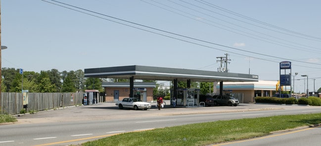
510 E Laburnum Ave
794-738-4873
01060A0000 0033; LABURNUM AVE AC .597 3 B1 33
Conveniencestore
Henrico
X
Virginia
5101290033E
0.60 AC
2025
Laburnum/Rte 360
2025
Richmond VA
200805
Richmond, VA
2,160 SF
DEMOGRAPHICS near 510 E Laburnum Ave
1 Mile
3 Mile
5 Mile
2024 Total Population
11,568
94,663
234,906
2029 Population
11,889
97,419
242,111
Pop Growth 2024-2029
+ 2.77%
+ 2.91%
+ 3.07%
Average Age
40
38
39
2024 Total Households
4,781
39,613
107,385
HH Growth 2024-2029
+ 2.70%
+ 3.03%
+ 3.16%
Median Household Inc
$45,843
$45,955
$58,500
Avg Household Size
2.40
2.10
2.10
2024 Avg HH Vehicles
1.00
1.00
2.00
Median Home Value
$194,351
$248,863
$278,332
Median Year Built
1954
1962
1963
Nearby Places
Map Layers
Map Styles
 Street
 Aerial
- Restaurants
- Banks
- Shops
- Fitness
- Groceries
PUBLIC TRANSPORTATION
COMMUTER RAIL
Richmond Main Street Amtrak Station (Northeast Regional - Amtrak)
DRIVE
WALK
Distance
Richmond Main Street Amtrak Station (Northeast Regional - Amtrak)
9 min
5.3 mi
Richmond Staples Mill Road Amtrak Station (Carolinian - Amtrak, Northeast Regional - Amtrak, Palmetto - Amtrak, Silver Meteor - Amtrak)
DRIVE
WALK
Distance
Richmond Staples Mill Road Amtrak Station (Carolinian - Amtrak, Northeast Regional - Amtrak, Palmetto - Amtrak, Silver Meteor - Amtrak)
11 min
5.5 mi
AIRPORT
Richmond International
DRIVE
WALK
Distance
Richmond International
18 min
9.8 mi
Freight Ports
Virginia Port Authority - Richmond
DRIVE
WALK
Distance
Virginia Port Authority - Richmond
20 min
11.6 mi
Nearby Properties
Address
Land Use
TOTAL SIZE
Lot Size
Zoning
Address
Land Use
TOTAL SIZE
Lot Size
Zoning
494,791 SF
38.85 AC
R-6
Address
Land Use
TOTAL SIZE
Lot Size
Zoning
450,000 SF
4.35 AC
RP REASEAR
Address
Land Use
TOTAL SIZE
Lot Size
Zoning
2,645,407 SF
116.30 AC
M2-C
Address
Land Use
TOTAL SIZE
Lot Size
Zoning
286,180 SF
8.78 AC
R-03 RESID
Address
Land Use
TOTAL SIZE
Lot Size
Zoning
11.17 AC
M-2 HEAVY
Address
Land Use
TOTAL SIZE
Lot Size
Zoning
482,958 SF
2.38 AC
M-1 LIGHT
Address
Land Use
TOTAL SIZE
Lot Size
Zoning
1,185 SF
2.54 AC
M-1 LIGHT
Address
Land Use
TOTAL SIZE
Lot Size
Zoning
14.89 AC
R-53 MULTI
Address
Land Use
TOTAL SIZE
Lot Size
Zoning
111,948 SF
2.64 AC
RP REASEAR
Address
Land Use
TOTAL SIZE
Lot Size
Zoning
16.14 AC
MULTIPLE Z
Address
Land Use
TOTAL SIZE
Lot Size
Zoning
111,876 SF
5.90 AC
M-1 LIGHT
Address
Land Use
TOTAL SIZE
Lot Size
Zoning
299,820 SF
3.16 AC
M-2 HEAVY
Address
Land Use
TOTAL SIZE
Lot Size
Zoning
80,519 SF
27.21 AC
I INSTITUT
Address
Land Use
TOTAL SIZE
Lot Size
Zoning
379,598 SF
11.11 AC
DCC-DOWNTO
Address
Land Use
TOTAL SIZE
Lot Size
Zoning
179,870 SF
7.36 AC
MULTIPLE Z
Address
Land Use
TOTAL SIZE
Lot Size
Zoning
97,713 SF
21.60 AC
B-4 CENTRA
Address
Land Use
TOTAL SIZE
Lot Size
Zoning
2,909 SF
2.47 AC
M-1 LIGHT
Address
Land Use
TOTAL SIZE
Lot Size
Zoning
3.25 AC
M-1 LIGHT
Address
Land Use
TOTAL SIZE
Lot Size
Zoning
59,574 SF
313.03 AC
MIXE
Address
Land Use
TOTAL SIZE
Lot Size
Zoning
224,108 SF
2.10 AC
M-2 HEAVY
Address
Land Use
TOTAL SIZE
Lot Size
Zoning
363,462 SF
11.01 AC
MULTIPLE Z
Address
Land Use
TOTAL SIZE
Lot Size
Zoning
228,297 SF
15.79 AC
M-1 LIGHT
Address
Land Use
TOTAL SIZE
Lot Size
Zoning
232,020 SF
15.88 AC
B-4 CENTRA
Address
Land Use
TOTAL SIZE
Lot Size
Zoning
179,827 SF
2.18 AC
R-03 RESID
Address
Land Use
TOTAL SIZE
Lot Size
Zoning
143,643 SF
1.37 AC
RP REASEAR
Address
Land Use
TOTAL SIZE
Lot Size
Zoning
273,822 SF
22.74 AC
R-5
Address
Land Use
TOTAL SIZE
Lot Size
Zoning
216,680 SF
4.45 AC
M-1 LIGHT
Address
Land Use
TOTAL SIZE
Lot Size
Zoning
110,790 SF
37.61 AC
R-2A
Address
Land Use
TOTAL SIZE
Lot Size
Zoning
292,981 SF
3.79 AC
MULTIPLE Z
Address
Land Use
TOTAL SIZE
Lot Size
Zoning
146,776 SF
2.36 AC
B-4 CENTRA
The World's #1 Commercial Real Estate Marketplace
Connect with us
© 2026 CoStar Group
The information above has been obtained from sources believed reliable. While we do not doubt its accuracy we have not verified it and make no guarantee, warranty or representation about it. It is your responsibility to independently confirm its accuracy and completeness. Any projections, opinions, assumptions, or estimates used are for example only and do not represent the current or future performance of the property. The value of this transaction to you depends on tax and other factors which should be evaluated by your tax, financial, and legal advisors. You and your advisors should conduct a careful, independent investigation of the property to determine to your satisfaction the suitability of the property for your needs.