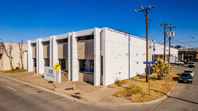
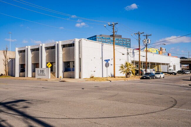
Property Record
510 S Good Latimer Expy, Dallas, TX 75226
NEARBY LISTINGS FOR SALE OR LEASE
Property Detail
510 S Good Latimer Expy
Dallas-Fort Worth-Arlington, TX
Railroad
00000103555000000
RAILROAD BLK 45/175 LTS 1-11 & PT ABDN ALLEY ACS 0.5583 VOL2002152/1291 DD07252002 CO-DC 0175 045 00100 1000175 045
Warehouse
Dallas
X
Texas
48113C0345J
1-11
2024
0.56 AC
2025
Central East Dallas
020402
Dallas/Ft Worth
29,716 SF
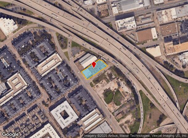
DEMOGRAPHICS near 510 S Good Latimer Expy
1 Mile
3 Mile
5 Mile
2024 Total Population
23,406
188,870
390,510
2029 Population
24,351
192,570
394,244
Pop Growth 2024-2029
+ 4.04%
+ 1.96%
+ 0.96%
Average Age
36
36
36
2024 Total Households
14,454
99,084
180,153
HH Growth 2024-2029
+ 4.25%
+ 1.93%
+ 1.09%
Median Household Inc
$79,755
$71,607
$69,233
Avg Household Size
1.50
1.80
2.10
2024 Avg HH Vehicles
1.00
1.00
2.00
Median Home Value
$350,310
$378,227
$404,496
Median Year Built
2003
1999
1990
Nearby Places
Map Layers
Map Styles
 Street
 Aerial
- Restaurants
- Banks
- Shops
- Fitness
- Groceries
PUBLIC TRANSPORTATION
TRANSIT/SUBWAY
Deep Ellum (Green Line - Dallas Area Rapid Transit (DART))
DRIVE
WALK
Distance
Deep Ellum (Green Line - Dallas Area Rapid Transit (DART))
2 min
10 min
0.5 mi
Baylor University Medical Center (Green Line - Dallas Area Rapid Transit (DART))
DRIVE
WALK
Distance
Baylor University Medical Center (Green Line - Dallas Area Rapid Transit (DART))
2 min
13 min
0.7 mi
Pearl (Blue Line - Dallas Area Rapid Transit (DART), Green Line - Dallas Area Rapid Transit (DART), Orange Line - Dallas Area Rapid Transit (DART), Red Line - Dallas Area Rapid Transit (DART))
DRIVE
WALK
Distance
Pearl (Blue Line - Dallas Area Rapid Transit (DART), Green Line - Dallas Area Rapid Transit (DART), Orange Line - Dallas Area Rapid Transit (DART), Red Line - Dallas Area Rapid Transit (DART))
3 min
19 min
1.0 mi
St Paul (Blue Line - Dallas Area Rapid Transit (DART), Green Line - Dallas Area Rapid Transit (DART), Orange Line - Dallas Area Rapid Transit (DART), Red Line - Dallas Area Rapid Transit (DART))
DRIVE
WALK
Distance
St Paul (Blue Line - Dallas Area Rapid Transit (DART), Green Line - Dallas Area Rapid Transit (DART), Orange Line - Dallas Area Rapid Transit (DART), Red Line - Dallas Area Rapid Transit (DART))
3 min
20 min
1.0 mi
COMMUTER RAIL
DRIVE
WALK
Distance
5 min
2.4 mi
DRIVE
WALK
Distance
9 min
4.3 mi
AIRPORT
Dallas Love Field
DRIVE
WALK
Distance
Dallas Love Field
15 min
6.4 mi
Dallas-Fort Worth International
DRIVE
WALK
Distance
Dallas-Fort Worth International
30 min
21.8 mi
SALE & LEASE HISTORY
LISTING DATE
SALE/LEASE

Sep 23, 2016
For Sale
Jan 20, 2023
For Sale
Nearby Properties
Address
Land Use
TOTAL SIZE
Lot Size
Zoning
Address
Land Use
TOTAL SIZE
Lot Size
Zoning
3,713,071 SF
9.94 AC
Address
Land Use
TOTAL SIZE
Lot Size
Zoning
1,298,826 SF
33.16 AC
Z163
Address
Land Use
TOTAL SIZE
Lot Size
Zoning
815,000 SF
7.20 AC
Z239
Address
Land Use
TOTAL SIZE
Lot Size
Zoning
1,676,176 SF
2.18 AC
Z239
Address
Land Use
TOTAL SIZE
Lot Size
Zoning
906,730 SF
3.09 AC
Z239
Address
Land Use
TOTAL SIZE
Lot Size
Zoning
1,308,710 SF
8.42 AC
Z21
Address
Land Use
TOTAL SIZE
Lot Size
Zoning
731,849 SF
3.13 AC
Z239
Address
Land Use
TOTAL SIZE
Lot Size
Zoning
1,896,570 SF
18.08 AC
Z151
Address
Land Use
TOTAL SIZE
Lot Size
Zoning
1,480,246 SF
1.86 AC
Z21
Address
Land Use
TOTAL SIZE
Lot Size
Zoning
1,291,660 SF
2.56 AC
Z248
Address
Land Use
TOTAL SIZE
Lot Size
Zoning
1,026,046 SF
2.89 AC
Z248
Address
Land Use
TOTAL SIZE
Lot Size
Zoning
864,909 SF
3.02 AC
Z248
Address
Land Use
TOTAL SIZE
Lot Size
Zoning
1,001,504 SF
3.37 AC
Z151
Address
Land Use
TOTAL SIZE
Lot Size
Zoning
1,424,070 SF
1.36 AC
Z21
Address
Land Use
TOTAL SIZE
Lot Size
Zoning
724,979 SF
1.05 AC
Z239
Address
Land Use
TOTAL SIZE
Lot Size
Zoning
893,159 SF
1.17 AC
Z21
Address
Land Use
TOTAL SIZE
Lot Size
Zoning
1,980,000 SF
2.57 AC
Z21
Address
Land Use
TOTAL SIZE
Lot Size
Zoning
857,292 SF
1.47 AC
Z239
Address
Land Use
TOTAL SIZE
Lot Size
Zoning
602,716 SF
11.21 AC
Z239
Address
Land Use
TOTAL SIZE
Lot Size
Zoning
763,198 SF
3.01 AC
Z248
Address
Land Use
TOTAL SIZE
Lot Size
Zoning
638,046 SF
2.11 AC
Z239
Address
Land Use
TOTAL SIZE
Lot Size
Zoning
486,300 SF
1.55 AC
Z239
Address
Land Use
TOTAL SIZE
Lot Size
Zoning
906,627 SF
3.83 AC
Z239
Address
Land Use
TOTAL SIZE
Lot Size
Zoning
653,557 SF
0.68 AC
Z248
Address
Land Use
TOTAL SIZE
Lot Size
Zoning
676,930 SF
1.38 AC
Z248
Address
Land Use
TOTAL SIZE
Lot Size
Zoning
536,874 SF
1.03 AC
Z239
Address
Land Use
TOTAL SIZE
Lot Size
Zoning
784,725 SF
2.33 AC
Z239
Address
Land Use
TOTAL SIZE
Lot Size
Zoning
2,695,010 SF
8.69 AC
Z239
Address
Land Use
TOTAL SIZE
Lot Size
Zoning
180,000 SF
4.66 AC
Z116
Address
Land Use
TOTAL SIZE
Lot Size
Zoning
818,188 SF
2.89 AC
Z239
The World's #1 Commercial Real Estate Marketplace
Connect with us
© 2025 CoStar Group
The information above has been obtained from sources believed reliable. While we do not doubt its accuracy we have not verified it and make no guarantee, warranty or representation about it. It is your responsibility to independently confirm its accuracy and completeness. Any projections, opinions, assumptions, or estimates used are for example only and do not represent the current or future performance of the property. The value of this transaction to you depends on tax and other factors which should be evaluated by your tax, financial, and legal advisors. You and your advisors should conduct a careful, independent investigation of the property to determine to your satisfaction the suitability of the property for your needs.