Property Record
510 Thatcher Ave, Saint Louis, MO 63147
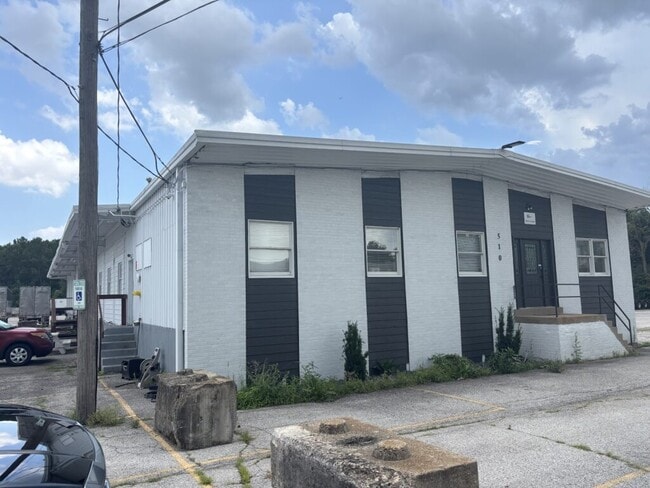


This Property Is For Sale
NEARBY LISTINGS FOR SALE OR LEASE
Property Detail
510 Thatcher Ave
St. Louis, MO-IL
Rr To German Town Addn
4221-00-0030-0
C. B. 4221 E RAILROAD 3.318 ACRES RR TO GERMAN TOWN ADDN LOT 1 TO 4 N-5 & VAC STRIP
Industrialgeneral
St. Louis City
X
Missouri
2903850053C
1-4
2024
3.32 AC
2025
St Louis City North
127000
St. Louis
6,775 SF
DEMOGRAPHICS near 510 Thatcher Ave
1 Mile
3 Mile
5 Mile
2024 Total Population
3,186
75,748
236,718
2029 Population
3,086
75,283
235,109
Pop Growth 2024-2029
(3.14%)
(0.61%)
(0.68%)
Average Age
43
41
39
2024 Total Households
1,320
32,188
102,168
HH Growth 2024-2029
(2.88%)
(0.60%)
(0.92%)
Median Household Inc
$28,437
$32,748
$36,869
Avg Household Size
2.20
2.30
2.20
2024 Avg HH Vehicles
1.00
1.00
1.00
Median Home Value
$59,081
$67,524
$80,269
Median Year Built
1950
1949
1953
Nearby Places
Map Layers
Map Styles
 Street
 Aerial
- Restaurants
- Banks
- Shops
- Fitness
- Groceries
PUBLIC TRANSPORTATION
COMMUTER RAIL
Um St. Louis South (Lambert Airport Shiloh-Scott - St. Louis MetroLink (MetroLink))
DRIVE
WALK
Distance
Um St. Louis South (Lambert Airport Shiloh-Scott - St. Louis MetroLink (MetroLink))
13 min
6.7 mi
Rock Road (Lambert Airport Shiloh-Scott - St. Louis MetroLink (MetroLink))
DRIVE
WALK
Distance
Rock Road (Lambert Airport Shiloh-Scott - St. Louis MetroLink (MetroLink))
15 min
7.1 mi
AIRPORT
St Louis Lambert International
DRIVE
WALK
Distance
St Louis Lambert International
17 min
9.6 mi
Scott AFB/Midamerica St Louis
DRIVE
WALK
Distance
Scott AFB/Midamerica St Louis
46 min
30.4 mi
Freight Ports
Port Milwaukee
DRIVE
WALK
Distance
Port Milwaukee
420 min
370.5 mi
Nearby Properties
Address
Land Use
TOTAL SIZE
Lot Size
Zoning
Address
Land Use
TOTAL SIZE
Lot Size
Zoning
Address
Land Use
TOTAL SIZE
Lot Size
Zoning
124.96 AC
J
Address
Land Use
TOTAL SIZE
Lot Size
Zoning
54.74 AC
K
Address
Land Use
TOTAL SIZE
Lot Size
Zoning
46.18 AC
A
Address
Land Use
TOTAL SIZE
Lot Size
Zoning
51,460 SF
101.96 AC
K
Address
Land Use
TOTAL SIZE
Lot Size
Zoning
229.57 AC
A
Address
Land Use
TOTAL SIZE
Lot Size
Zoning
353,312 SF
17.84 AC
K
Address
Land Use
TOTAL SIZE
Lot Size
Zoning
429,181 SF
23.56 AC
K
Address
Land Use
TOTAL SIZE
Lot Size
Zoning
4.07 AC
31R-1
Address
Land Use
TOTAL SIZE
Lot Size
Zoning
38.62 AC
AF
Address
Land Use
TOTAL SIZE
Lot Size
Zoning
471,077 SF
16.09 AC
K
Address
Land Use
TOTAL SIZE
Lot Size
Zoning
1.80 AC
31R-1
Address
Land Use
TOTAL SIZE
Lot Size
Zoning
10,362 SF
19.03 AC
81R-2
Address
Land Use
TOTAL SIZE
Lot Size
Zoning
130.85 AC
B
Address
Land Use
TOTAL SIZE
Lot Size
Zoning
3,256 SF
38.63 AC
88R-3
Address
Land Use
TOTAL SIZE
Lot Size
Zoning
Address
Land Use
TOTAL SIZE
Lot Size
Zoning
127.48 AC
B
Address
Land Use
TOTAL SIZE
Lot Size
Zoning
88,466 SF
2.13 AC
31C-2S
Address
Land Use
TOTAL SIZE
Lot Size
Zoning
297,169 SF
18.01 AC
K
Address
Land Use
TOTAL SIZE
Lot Size
Zoning
5.23 AC
31R-1
Address
Land Use
TOTAL SIZE
Lot Size
Zoning
51,222 SF
5.23 AC
31C-3
Address
Land Use
TOTAL SIZE
Lot Size
Zoning
11,126 SF
7.21 AC
J
Address
Land Use
TOTAL SIZE
Lot Size
Zoning
6.37 AC
31R-1
Address
Land Use
TOTAL SIZE
Lot Size
Zoning
45,106 SF
8.07 AC
G
Address
Land Use
TOTAL SIZE
Lot Size
Zoning
5 AC
88R-3
Address
Land Use
TOTAL SIZE
Lot Size
Zoning
76,200 SF
4.85 AC
A
Address
Land Use
TOTAL SIZE
Lot Size
Zoning
36,276 SF
2.98 AC
B
Address
Land Use
TOTAL SIZE
Lot Size
Zoning
1.10 AC
C3
Address
Land Use
TOTAL SIZE
Lot Size
Zoning
4.71 AC
31R-1
Address
Land Use
TOTAL SIZE
Lot Size
Zoning
73,260 SF
1.80 AC
R1
The World's #1 Commercial Real Estate Marketplace
Connect with us
© 2026 CoStar Group
The information above has been obtained from sources believed reliable. While we do not doubt its accuracy we have not verified it and make no guarantee, warranty or representation about it. It is your responsibility to independently confirm its accuracy and completeness. Any projections, opinions, assumptions, or estimates used are for example only and do not represent the current or future performance of the property. The value of this transaction to you depends on tax and other factors which should be evaluated by your tax, financial, and legal advisors. You and your advisors should conduct a careful, independent investigation of the property to determine to your satisfaction the suitability of the property for your needs.