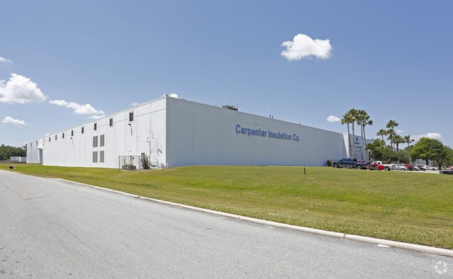
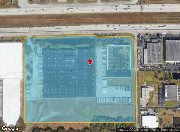
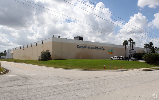
Property Record
5100 Frontage Rd S, Lakeland, FL 33815
NEARBY LISTINGS FOR SALE OR LEASE
Property Detail
5100 Frontage Rd S
Lakeland-Winter Haven, FL
Alameda Heights
23-28-19-000000-032010
N1/2 OF SE1/4 OF NW1/4 LESS N 88 FT FOR FRONTAGE RD & LESS ADDITIONAL R/W & LESS ADDL R/W FOR SR 400 AS REC IN OR 3814 PG 2276 & COMM SW COR OF NE1/4 OF SW1/4 RUN N01-30-50W 1456.62 FT N01-30-50W 529.71 FT TO S LINE OF N1/2 OF SE1/4 OF NW1/4 RUN N88-
Lightindustrial
Polk
A
Florida
12105C0291G
7
2024
30.12 AC
2025
Polk County
012004
Tampa/St Petersburg
451,505 SF
DEMOGRAPHICS near 5100 Frontage Rd S
1 Mile
3 Mile
5 Mile
2024 Total Population
1,164
13,197
68,860
2029 Population
1,313
15,358
80,265
Pop Growth 2024-2029
+ 12.80%
+ 16.37%
+ 16.56%
Average Age
40
41
41
2024 Total Households
412
5,014
26,346
HH Growth 2024-2029
+ 13.11%
+ 16.77%
+ 16.96%
Median Household Inc
$66,915
$63,777
$50,763
Avg Household Size
2.80
2.60
2.50
2024 Avg HH Vehicles
2.00
2.00
2.00
Median Home Value
$264,024
$236,062
$169,468
Median Year Built
1992
1986
1985
Nearby Places
Map Layers
Map Styles
 Street
 Aerial
- Restaurants
- Banks
- Shops
- Fitness
- Groceries
PUBLIC TRANSPORTATION
COMMUTER RAIL
Lakeland (Silver Star - Amtrak)
DRIVE
WALK
Distance
Lakeland (Silver Star - Amtrak)
12 min
6.5 mi
AIRPORT
Tampa International
DRIVE
WALK
Distance
Tampa International
45 min
34.9 mi
Freight Ports
Port of Tampa Bay
DRIVE
WALK
Distance
Port of Tampa Bay
38 min
28.4 mi
Nearby Properties
Address
Land Use
TOTAL SIZE
Lot Size
Zoning
Address
Land Use
TOTAL SIZE
Lot Size
Zoning
2,095,234 SF
102.45 AC
PUD
Address
Land Use
TOTAL SIZE
Lot Size
Zoning
1,055,503 SF
112.72 AC
R-4
Address
Land Use
TOTAL SIZE
Lot Size
Zoning
1,210,880 SF
405.82 AC
PUD
Address
Land Use
TOTAL SIZE
Lot Size
Zoning
1,494,080 SF
116.77 AC
Address
Land Use
TOTAL SIZE
Lot Size
Zoning
705,615 SF
33.05 AC
Address
Land Use
TOTAL SIZE
Lot Size
Zoning
711,568 SF
42.87 AC
PD
Address
Land Use
TOTAL SIZE
Lot Size
Zoning
805,336 SF
52.50 AC
I
Address
Land Use
TOTAL SIZE
Lot Size
Zoning
779,760 SF
67.03 AC
I
Address
Land Use
TOTAL SIZE
Lot Size
Zoning
711,568 SF
43.33 AC
PD
Address
Land Use
TOTAL SIZE
Lot Size
Zoning
723,962 SF
47.49 AC
I
Address
Land Use
TOTAL SIZE
Lot Size
Zoning
655,123 SF
45.28 AC
Address
Land Use
TOTAL SIZE
Lot Size
Zoning
1,004,426 SF
93.42 AC
C4
Address
Land Use
TOTAL SIZE
Lot Size
Zoning
520,806 SF
25.62 AC
Address
Land Use
TOTAL SIZE
Lot Size
Zoning
505,506 SF
50.60 AC
MU-R/C/I
Address
Land Use
TOTAL SIZE
Lot Size
Zoning
492,960 SF
22.09 AC
Address
Land Use
TOTAL SIZE
Lot Size
Zoning
602,125 SF
43.97 AC
Address
Land Use
TOTAL SIZE
Lot Size
Zoning
599,280 SF
35.27 AC
GI
Address
Land Use
TOTAL SIZE
Lot Size
Zoning
566,274 SF
33.79 AC
GI
Address
Land Use
TOTAL SIZE
Lot Size
Zoning
417,890 SF
14.59 AC
Address
Land Use
TOTAL SIZE
Lot Size
Zoning
387,165 SF
37 AC
I2
Address
Land Use
TOTAL SIZE
Lot Size
Zoning
568,801 SF
37.13 AC
C4
Address
Land Use
TOTAL SIZE
Lot Size
Zoning
220,510 SF
37.56 AC
I
Address
Land Use
TOTAL SIZE
Lot Size
Zoning
172,176 SF
8.93 AC
RE2
Address
Land Use
TOTAL SIZE
Lot Size
Zoning
333,718 SF
28.99 AC
I
Address
Land Use
TOTAL SIZE
Lot Size
Zoning
349,920 SF
22.21 AC
Address
Land Use
TOTAL SIZE
Lot Size
Zoning
300,411 SF
18.77 AC
I
Address
Land Use
TOTAL SIZE
Lot Size
Zoning
492,180 SF
32.61 AC
PD
Address
Land Use
TOTAL SIZE
Lot Size
Zoning
441,480 SF
24.28 AC
Address
Land Use
TOTAL SIZE
Lot Size
Zoning
221,500 SF
19.54 AC
XX
The World's #1 Commercial Real Estate Marketplace
Connect with us
© 2025 CoStar Group
The information above has been obtained from sources believed reliable. While we do not doubt its accuracy we have not verified it and make no guarantee, warranty or representation about it. It is your responsibility to independently confirm its accuracy and completeness. Any projections, opinions, assumptions, or estimates used are for example only and do not represent the current or future performance of the property. The value of this transaction to you depends on tax and other factors which should be evaluated by your tax, financial, and legal advisors. You and your advisors should conduct a careful, independent investigation of the property to determine to your satisfaction the suitability of the property for your needs.