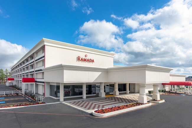
Property Record
5100 N State Line Ave, Texarkana, AR 71854

NEARBY LISTINGS FOR SALE OR LEASE
-
-
View all Texarkana listings for sale on LoopNet.com
Property Detail
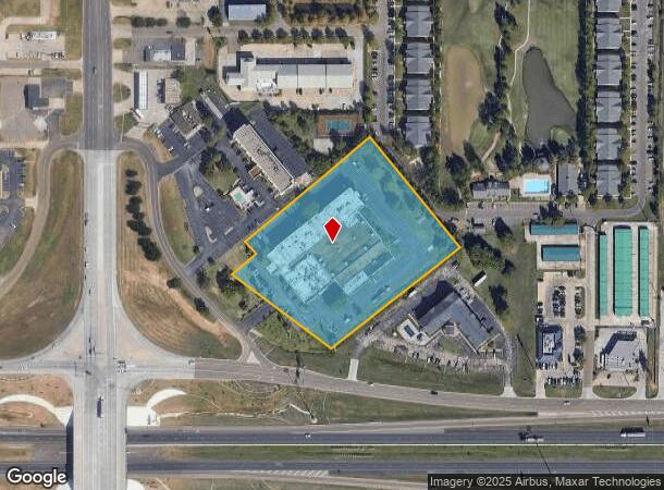
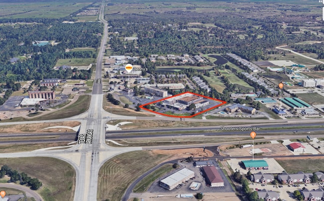
5100 N State Line Ave
00210100
07-15S-28W
Motel
PT FRL N/2 NW 4.986AC N OF I-30 & PT SE NW .001AC
X
Miller
48037C0360E
Arkansas
2025
4.99 AC
2025
Arkansas South Area
020801
Other Market Areas
132,726 SF
Texarkana, TX-AR
DEMOGRAPHICS near 5100 N State Line Ave
1 Mile
3 Mile
5 Mile
2024 Total Population
3,944
35,965
64,464
2029 Population
3,912
35,912
64,699
Pop Growth 2024-2029
(0.81%)
(0.15%)
+ 0.36%
Average Age
40
40
39
2024 Total Households
1,659
14,905
25,836
HH Growth 2024-2029
(0.78%)
(0.14%)
+ 0.37%
Median Household Inc
$48,449
$49,251
$43,809
Avg Household Size
2.20
2.30
2.30
2024 Avg HH Vehicles
2.00
2.00
2.00
Median Home Value
$176,973
$149,778
$146,319
Median Year Built
1989
1978
1979
Nearby Places
Map Layers
Map Styles
 Street
 Aerial
- Restaurants
- Banks
- Shops
- Fitness
- Groceries
PUBLIC TRANSPORTATION
COMMUTER RAIL
Texarkana Amtrak Station (Texas Eagle - Amtrak)
DRIVE
WALK
Distance
Texarkana Amtrak Station (Texas Eagle - Amtrak)
7 min
3.8 mi
AIRPORT
Texarkana Regional-Webb Field
DRIVE
WALK
Distance
Texarkana Regional-Webb Field
14 min
6.0 mi
Freight Ports
Port of Shreveport
DRIVE
WALK
Distance
Port of Shreveport
112 min
97.3 mi
SALE & LEASE HISTORY
LISTING DATE
SALE/LEASE

Sep 25, 2019
For Sale
Sep 24, 2016
For Sale
Nearby Properties
Address
Land Use
TOTAL SIZE
Lot Size
Zoning
Address
Land Use
TOTAL SIZE
Lot Size
Zoning
37.76 AC
Address
Land Use
TOTAL SIZE
Lot Size
Zoning
594,669 SF
26.19 AC
Address
Land Use
TOTAL SIZE
Lot Size
Zoning
22.35 AC
Address
Land Use
TOTAL SIZE
Lot Size
Zoning
Address
Land Use
TOTAL SIZE
Lot Size
Zoning
162,169 SF
19.18 AC
Address
Land Use
TOTAL SIZE
Lot Size
Zoning
133,136 SF
5.80 AC
Address
Land Use
TOTAL SIZE
Lot Size
Zoning
11,320 SF
142 AC
Address
Land Use
TOTAL SIZE
Lot Size
Zoning
97,914 SF
3.01 AC
Address
Land Use
TOTAL SIZE
Lot Size
Zoning
73,675 SF
4.44 AC
Address
Land Use
TOTAL SIZE
Lot Size
Zoning
533,299 SF
50.60 AC
Address
Land Use
TOTAL SIZE
Lot Size
Zoning
51,587 SF
6.44 AC
Address
Land Use
TOTAL SIZE
Lot Size
Zoning
133,067 SF
11.20 AC
Address
Land Use
TOTAL SIZE
Lot Size
Zoning
18.64 AC
Address
Land Use
TOTAL SIZE
Lot Size
Zoning
51,049 SF
1.78 AC
Address
Land Use
TOTAL SIZE
Lot Size
Zoning
165,001 SF
26.11 AC
Address
Land Use
TOTAL SIZE
Lot Size
Zoning
109,855 SF
6.24 AC
Address
Land Use
TOTAL SIZE
Lot Size
Zoning
18,105 SF
2.50 AC
Address
Land Use
TOTAL SIZE
Lot Size
Zoning
175,650 SF
15.56 AC
Address
Land Use
TOTAL SIZE
Lot Size
Zoning
25,006 SF
3.93 AC
Address
Land Use
TOTAL SIZE
Lot Size
Zoning
49,330 SF
2.26 AC
Address
Land Use
TOTAL SIZE
Lot Size
Zoning
160,484 SF
10.01 AC
Address
Land Use
TOTAL SIZE
Lot Size
Zoning
42,117 SF
0.86 AC
Address
Land Use
TOTAL SIZE
Lot Size
Zoning
22,103 SF
3.43 AC
Address
Land Use
TOTAL SIZE
Lot Size
Zoning
108,928 SF
6.26 AC
Address
Land Use
TOTAL SIZE
Lot Size
Zoning
94,536 SF
3.84 AC
Address
Land Use
TOTAL SIZE
Lot Size
Zoning
64,449 SF
6.23 AC
Address
Land Use
TOTAL SIZE
Lot Size
Zoning
55,000 SF
6.36 AC
Address
Land Use
TOTAL SIZE
Lot Size
Zoning
41,627 SF
6.12 AC
Address
Land Use
TOTAL SIZE
Lot Size
Zoning
50,355 SF
18.21 AC
Address
Land Use
TOTAL SIZE
Lot Size
Zoning
28,221 SF
7.72 AC
The World's #1 Commercial Real Estate Marketplace
Connect with us
© 2025 CoStar Group
The information above has been obtained from sources believed reliable. While we do not doubt its accuracy we have not verified it and make no guarantee, warranty or representation about it. It is your responsibility to independently confirm its accuracy and completeness. Any projections, opinions, assumptions, or estimates used are for example only and do not represent the current or future performance of the property. The value of this transaction to you depends on tax and other factors which should be evaluated by your tax, financial, and legal advisors. You and your advisors should conduct a careful, independent investigation of the property to determine to your satisfaction the suitability of the property for your needs.