Property Record
5100 W 12Th St, Sioux Falls, SD 57107
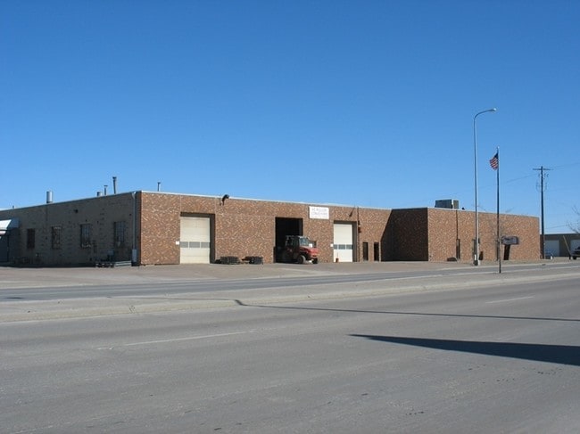

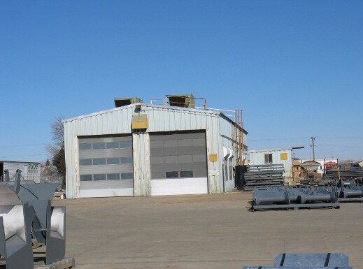
Property Detail
5100 W 12Th St
37284
LOT 1A P & J ENTERPRISES ADDITION TO THE CITY OF SIOUX FALLS
Autorepair
Minnehaha
B and X Area of moderate flood hazard, usually the area between the limits of the 100-year and 500-year floods.
South Dakota
2024
1a
2024
9.23 AC
001001
Other Market Areas
72,947 SF
Sioux Falls, SD-MN
NEARBY LISTINGS FOR SALE OR LEASE
DEMOGRAPHICS near 5100 W 12Th St
1 mile
3 mile
5 mile
2025 Total Population
9,080
73,382
143,306
2030 Population
9,598
77,122
151,801
Pop Growth 2025-2030
+ 5.70%
+ 5.10%
+ 5.93%
Average Age
36
38
38
2025 Total Households
3,826
31,310
59,987
HH Growth 2025-2030
+ 6.17%
+ 5.57%
+ 6.37%
Median Household Inc
$62,214
$64,634
$68,268
Avg Household Size
2.30
2.20
2.30
2025 Avg HH Vehicles
2.00
2.00
2.00
Median Home Value
$105,021
$264,397
$274,843
Median Year Built
1996
1988
1990
Nearby Places
Map Layers
Map Styles
 Street
 Aerial
Transit
 Traffic
 Biking
Places
Listings with unknown addresses are not visible on the map
- Restaurants
- Banks
- Shops
- Fitness
- Groceries
PUBLIC TRANSPORTATION
AIRPORT
Joe Foss Field
Drive
Walk
Distance
Joe Foss Field
13 min
6.9 mi
Nearby Properties
Address
Land Use
TOTAL SIZE
Lot Size
Zoning
Address
Land Use
TOTAL SIZE
Lot Size
Zoning
80,415 SF
13.13 AC
Address
Land Use
TOTAL SIZE
Lot Size
Zoning
639,393 SF
53.46 AC
FP;FP
Address
Land Use
TOTAL SIZE
Lot Size
Zoning
8.90 AC
C1;NEIGHBO
Address
Land Use
TOTAL SIZE
Lot Size
Zoning
Address
Land Use
TOTAL SIZE
Lot Size
Zoning
9.41 AC
Address
Land Use
TOTAL SIZE
Lot Size
Zoning
360,262 SF
26 AC
Address
Land Use
TOTAL SIZE
Lot Size
Zoning
32,169 SF
9.91 AC
Address
Land Use
TOTAL SIZE
Lot Size
Zoning
55,998 SF
5.42 AC
FP;FP
Address
Land Use
TOTAL SIZE
Lot Size
Zoning
51,004 SF
3.99 AC
Address
Land Use
TOTAL SIZE
Lot Size
Zoning
72,553 SF
0.97 AC
Address
Land Use
TOTAL SIZE
Lot Size
Zoning
15.89 AC
Address
Land Use
TOTAL SIZE
Lot Size
Zoning
3,254 SF
2.13 AC
Address
Land Use
TOTAL SIZE
Lot Size
Zoning
77,853 SF
10.42 AC
Address
Land Use
TOTAL SIZE
Lot Size
Zoning
99,834 SF
6.58 AC
Address
Land Use
TOTAL SIZE
Lot Size
Zoning
36,986 SF
8.49 AC
FP;FP
Address
Land Use
TOTAL SIZE
Lot Size
Zoning
140,816 SF
13.80 AC
Address
Land Use
TOTAL SIZE
Lot Size
Zoning
100,053 SF
8.50 AC
FP;FP
Address
Land Use
TOTAL SIZE
Lot Size
Zoning
75,786 SF
7.14 AC
Address
Land Use
TOTAL SIZE
Lot Size
Zoning
1.66 AC
FP;FP
Address
Land Use
TOTAL SIZE
Lot Size
Zoning
106,064 SF
35.38 AC
Address
Land Use
TOTAL SIZE
Lot Size
Zoning
23,832 SF
216 AC
Address
Land Use
TOTAL SIZE
Lot Size
Zoning
137,651 SF
22.28 AC
Address
Land Use
TOTAL SIZE
Lot Size
Zoning
Address
Land Use
TOTAL SIZE
Lot Size
Zoning
146,718 SF
1.65 AC
Address
Land Use
TOTAL SIZE
Lot Size
Zoning
47,142 SF
6.09 AC
Address
Land Use
TOTAL SIZE
Lot Size
Zoning
167,162 SF
17.11 AC
Address
Land Use
TOTAL SIZE
Lot Size
Zoning
168,359 SF
9.65 AC
NO;SPECIAL
Address
Land Use
TOTAL SIZE
Lot Size
Zoning
26,601 SF
5.31 AC
Address
Land Use
TOTAL SIZE
Lot Size
Zoning
72,601 SF
15.33 AC
Address
Land Use
TOTAL SIZE
Lot Size
Zoning
21,060 SF
6.70 AC
FP;FP
The World's #1 Commercial Real Estate Marketplace
Connect with us
© 2026 CoStar Group
The information above has been obtained from sources believed reliable. While we do not doubt its accuracy we have not verified it and make no guarantee, warranty or representation about it. It is your responsibility to independently confirm its accuracy and completeness. Any projections, opinions, assumptions, or estimates used are for example only and do not represent the current or future performance of the property. The value of this transaction to you depends on tax and other factors which should be evaluated by your tax, financial, and legal advisors. You and your advisors should conduct a careful, independent investigation of the property to determine to your satisfaction the suitability of the property for your needs.