Property Record
5101 Groveport Rd, Obetz, OH 43207

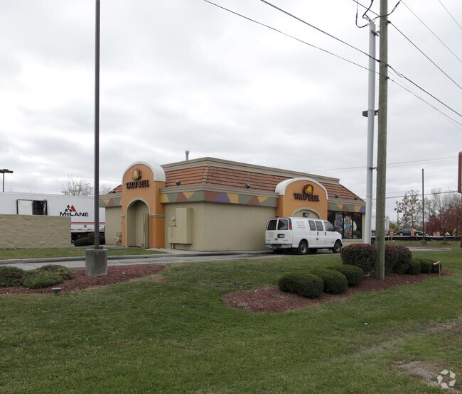

Property Detail
5101 Groveport Rd
152-000709
GROVEPORT ROAD ACRES 0.640 R22 T4 S24
Restaurantdrivein
Franklin
AE The base floodplain where base flood elevations are provided. AE Zones are now used on new format FIRMs instead of A1-A30 Zones.
Ohio
2024
0.64 AC
2025
Southeast
009590
Columbus
1,944 SF
Columbus, OH
NEARBY LISTINGS FOR SALE OR LEASE
DEMOGRAPHICS near 5101 Groveport Rd
1 mile
3 mile
5 mile
2025 Total Population
3,393
33,999
93,937
2030 Population
3,515
34,983
97,239
Pop Growth 2025-2030
+ 3.60%
+ 2.89%
+ 3.52%
Average Age
38
39
39
2025 Total Households
1,199
12,658
37,773
HH Growth 2025-2030
+ 3.67%
+ 2.99%
+ 3.65%
Median Household Inc
$71,327
$72,856
$59,573
Avg Household Size
2.80
2.60
2.40
2025 Avg HH Vehicles
2.00
2.00
2.00
Median Home Value
$218,826
$212,896
$201,271
Median Year Built
1987
1975
1972
Nearby Places
Map Layers
Map Styles
 Street
 Aerial
Layers
 Traffic
 Biking
Places
Listings with unknown addresses are not visible on the map
- Restaurants
- Banks
- Shops
- Fitness
- Groceries
PUBLIC TRANSPORTATION
AIRPORT
Rickenbacker International
Drive
Walk
Distance
Rickenbacker International
8 min
4.3 mi
John Glenn Columbus International
Drive
Walk
Distance
John Glenn Columbus International
20 min
12.1 mi
Nearby Properties
Address
Land Use
TOTAL SIZE
Lot Size
Zoning
Address
Land Use
TOTAL SIZE
Lot Size
Zoning
4,200 SF
852.55 AC
Address
Land Use
TOTAL SIZE
Lot Size
Zoning
1,075,600 SF
49.33 AC
Address
Land Use
TOTAL SIZE
Lot Size
Zoning
471,215 SF
49.74 AC
Address
Land Use
TOTAL SIZE
Lot Size
Zoning
1,466,512 SF
49.72 AC
Address
Land Use
TOTAL SIZE
Lot Size
Zoning
1,054,500 SF
59.77 AC
Address
Land Use
TOTAL SIZE
Lot Size
Zoning
1,219,000 SF
59.32 AC
Address
Land Use
TOTAL SIZE
Lot Size
Zoning
1,021,020 SF
68.44 AC
Address
Land Use
TOTAL SIZE
Lot Size
Zoning
1,600,052 SF
70.19 AC
Address
Land Use
TOTAL SIZE
Lot Size
Zoning
977,584 SF
70.14 AC
Address
Land Use
TOTAL SIZE
Lot Size
Zoning
1,280,501 SF
69.60 AC
Address
Land Use
TOTAL SIZE
Lot Size
Zoning
816,200 SF
51.08 AC
Address
Land Use
TOTAL SIZE
Lot Size
Zoning
959,688 SF
55.34 AC
Address
Land Use
TOTAL SIZE
Lot Size
Zoning
778,272 SF
42.31 AC
Address
Land Use
TOTAL SIZE
Lot Size
Zoning
903,780 SF
45.43 AC
Address
Land Use
TOTAL SIZE
Lot Size
Zoning
720,200 SF
35.71 AC
Address
Land Use
TOTAL SIZE
Lot Size
Zoning
785,854 SF
30.85 AC
Address
Land Use
TOTAL SIZE
Lot Size
Zoning
541,910 SF
36.84 AC
Address
Land Use
TOTAL SIZE
Lot Size
Zoning
743,315 SF
42.17 AC
Address
Land Use
TOTAL SIZE
Lot Size
Zoning
567,000 SF
23.08 AC
Address
Land Use
TOTAL SIZE
Lot Size
Zoning
130,865 SF
9.97 AC
Address
Land Use
TOTAL SIZE
Lot Size
Zoning
767,697 SF
39.49 AC
Address
Land Use
TOTAL SIZE
Lot Size
Zoning
655,288 SF
40.76 AC
Address
Land Use
TOTAL SIZE
Lot Size
Zoning
705,600 SF
43.41 AC
Address
Land Use
TOTAL SIZE
Lot Size
Zoning
590,225 SF
42.21 AC
Address
Land Use
TOTAL SIZE
Lot Size
Zoning
245,756 SF
102.40 AC
Address
Land Use
TOTAL SIZE
Lot Size
Zoning
737,054 SF
37.15 AC
Address
Land Use
TOTAL SIZE
Lot Size
Zoning
614,138 SF
36.90 AC
Address
Land Use
TOTAL SIZE
Lot Size
Zoning
250,174 SF
178.12 AC
Address
Land Use
TOTAL SIZE
Lot Size
Zoning
642,331 SF
25.16 AC
Address
Land Use
TOTAL SIZE
Lot Size
Zoning
668,447 SF
41.68 AC
The World's #1 Commercial Real Estate Marketplace
Connect with us
© 2026 CoStar Group
The information above has been obtained from sources believed reliable. While we do not doubt its accuracy we have not verified it and make no guarantee, warranty or representation about it. It is your responsibility to independently confirm its accuracy and completeness. Any projections, opinions, assumptions, or estimates used are for example only and do not represent the current or future performance of the property. The value of this transaction to you depends on tax and other factors which should be evaluated by your tax, financial, and legal advisors. You and your advisors should conduct a careful, independent investigation of the property to determine to your satisfaction the suitability of the property for your needs.