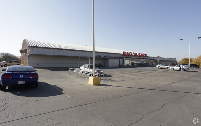
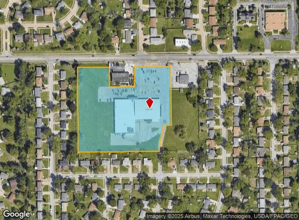
Property Record
5101 Harrison St, Omaha, NE 68157

NEARBY LISTINGS FOR SALE OR LEASE
Property Detail
5101 Harrison St
Omaha, NE-IA
Sun Valley
011103876
LOT 1 SUN VALLEY REPLAT I
Commercialnec
Sarpy
X
Nebraska
31153C0080G
1
2024
5.98 AC
2025
Sarpy East
010503
Omaha/Council Bluffs
33,500 SF
DEMOGRAPHICS near 5101 Harrison St
1 Mile
3 Mile
5 Mile
2024 Total Population
7,611
83,388
235,948
2029 Population
7,906
86,580
244,917
Pop Growth 2024-2029
+ 3.88%
+ 3.83%
+ 3.80%
Average Age
39
37
37
2024 Total Households
2,704
30,885
92,506
HH Growth 2024-2029
+ 3.99%
+ 3.98%
+ 3.86%
Median Household Inc
$75,124
$63,261
$63,805
Avg Household Size
2.70
2.60
2.40
2024 Avg HH Vehicles
2.00
2.00
2.00
Median Home Value
$167,950
$178,170
$204,107
Median Year Built
1967
1970
1971
Nearby Places
Map Layers
Map Styles
 Street
 Aerial
- Restaurants
- Banks
- Shops
- Fitness
- Groceries
PUBLIC TRANSPORTATION
COMMUTER RAIL
Omaha Amtrak Station (California Zephyr - Amtrak)
DRIVE
WALK
Distance
Omaha Amtrak Station (California Zephyr - Amtrak)
14 min
7.8 mi
Omaha Amtrak Station (California Zephyr - Amtrak)
DRIVE
WALK
Distance
Omaha Amtrak Station (California Zephyr - Amtrak)
14 min
8.0 mi
AIRPORT
Eppley Airfield
DRIVE
WALK
Distance
Eppley Airfield
22 min
11.9 mi
Freight Ports
Tulsa Port Of Catoosa
DRIVE
WALK
Distance
Tulsa Port Of Catoosa
461 min
416.2 mi
Nearby Properties
Address
Land Use
TOTAL SIZE
Lot Size
Zoning
Address
Land Use
TOTAL SIZE
Lot Size
Zoning
25,204 SF
2.34 AC
R4
Address
Land Use
TOTAL SIZE
Lot Size
Zoning
341,667 SF
24.15 AC
Address
Land Use
TOTAL SIZE
Lot Size
Zoning
276,509 SF
3.67 AC
Address
Land Use
TOTAL SIZE
Lot Size
Zoning
28,913 SF
2.04 AC
Address
Land Use
TOTAL SIZE
Lot Size
Zoning
294,672 SF
15.06 AC
Address
Land Use
TOTAL SIZE
Lot Size
Zoning
646,213 SF
37.22 AC
Address
Land Use
TOTAL SIZE
Lot Size
Zoning
13,930 SF
1.04 AC
Address
Land Use
TOTAL SIZE
Lot Size
Zoning
97,617 SF
49.05 AC
Address
Land Use
TOTAL SIZE
Lot Size
Zoning
407,410 SF
4.03 AC
Address
Land Use
TOTAL SIZE
Lot Size
Zoning
108,554 SF
4.85 AC
Address
Land Use
TOTAL SIZE
Lot Size
Zoning
217,511 SF
25.06 AC
Address
Land Use
TOTAL SIZE
Lot Size
Zoning
172,272 SF
7.48 AC
R6
Address
Land Use
TOTAL SIZE
Lot Size
Zoning
170,665 SF
10.94 AC
Address
Land Use
TOTAL SIZE
Lot Size
Zoning
130,245 SF
6.93 AC
Address
Land Use
TOTAL SIZE
Lot Size
Zoning
135,252 SF
7.07 AC
Address
Land Use
TOTAL SIZE
Lot Size
Zoning
294,520 SF
13.79 AC
GI
Address
Land Use
TOTAL SIZE
Lot Size
Zoning
0.01 AC
Address
Land Use
TOTAL SIZE
Lot Size
Zoning
2,063 SF
5.16 AC
Address
Land Use
TOTAL SIZE
Lot Size
Zoning
121,052 SF
7.64 AC
Address
Land Use
TOTAL SIZE
Lot Size
Zoning
193,967 SF
7.27 AC
Address
Land Use
TOTAL SIZE
Lot Size
Zoning
236,067 SF
10.12 AC
HI
Address
Land Use
TOTAL SIZE
Lot Size
Zoning
203,595 SF
7.60 AC
GI
Address
Land Use
TOTAL SIZE
Lot Size
Zoning
216,396 SF
9.75 AC
R6
Address
Land Use
TOTAL SIZE
Lot Size
Zoning
33,713 SF
14.39 AC
Address
Land Use
TOTAL SIZE
Lot Size
Zoning
120,068 SF
6.10 AC
Address
Land Use
TOTAL SIZE
Lot Size
Zoning
137,526 SF
11.76 AC
Address
Land Use
TOTAL SIZE
Lot Size
Zoning
126,910 SF
13.49 AC
Address
Land Use
TOTAL SIZE
Lot Size
Zoning
131,366 SF
8.13 AC
R6
Address
Land Use
TOTAL SIZE
Lot Size
Zoning
141,600 SF
8.31 AC
Address
Land Use
TOTAL SIZE
Lot Size
Zoning
139,009 SF
2.04 AC
The World's #1 Commercial Real Estate Marketplace
Connect with us
© 2026 CoStar Group
The information above has been obtained from sources believed reliable. While we do not doubt its accuracy we have not verified it and make no guarantee, warranty or representation about it. It is your responsibility to independently confirm its accuracy and completeness. Any projections, opinions, assumptions, or estimates used are for example only and do not represent the current or future performance of the property. The value of this transaction to you depends on tax and other factors which should be evaluated by your tax, financial, and legal advisors. You and your advisors should conduct a careful, independent investigation of the property to determine to your satisfaction the suitability of the property for your needs.