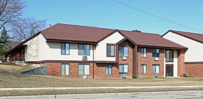
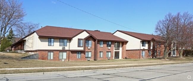
Property Record
5101 Wright Ave, Racine, WI 53406

Property Detail
5101 Wright Ave
276-000022881001
SE 1/4 SECTION 13-3-22 BEG INTER SLN WRIGHT AVE + WLN PERRY AVE, S ALG SD WLN 400.04 FT, W 358.47 FT, N 364.51 FT TO SLN WRIG
Commercialnec
Racine
R4
Wisconsin
B and X Area of moderate flood hazard, usually the area between the limits of the 100-year and 500-year floods.
3.01 AC
2025
Sturtevant
2025
Milwaukee/Madison
001001
Racine-Mount Pleasant, WI
65,403 SF
NEARBY LISTINGS FOR SALE OR LEASE
-
-
View all Racine listings for sale on LoopNet.com
DEMOGRAPHICS near 5101 Wright Ave
1 mile
3 mile
5 mile
2025 Total Population
13,070
85,014
124,383
2030 Population
13,134
85,682
125,340
Pop Growth 2025-2030
+ 0.49%
+ 0.79%
+ 0.77%
Average Age
41
40
40
2025 Total Households
5,753
34,411
50,071
HH Growth 2025-2030
+ 0.52%
+ 0.78%
+ 0.78%
Median Household Inc
$65,166
$65,458
$67,136
Avg Household Size
2.20
2.30
2.30
2025 Avg HH Vehicles
2.00
2.00
2.00
Median Home Value
$172,409
$185,902
$201,447
Median Year Built
1962
1961
1962
Nearby Places
Map Layers
Map Styles
 Street
 Aerial
Transit
 Traffic
 Biking
Places
Listings with unknown addresses are not visible on the map
- Restaurants
- Banks
- Shops
- Fitness
- Groceries
PUBLIC TRANSPORTATION
COMMUTER RAIL
Sturtevant Amtrak Station (Hiawatha Service - Amtrak)
Drive
Walk
Distance
Sturtevant Amtrak Station (Hiawatha Service - Amtrak)
9 min
4.4 mi
AIRPORT
General Mitchell International
Drive
Walk
Distance
General Mitchell International
32 min
23.4 mi
Freight Ports
Port Milwaukee
Drive
Walk
Distance
Port Milwaukee
37 min
27.3 mi
Nearby Properties
Address
Land Use
TOTAL SIZE
Lot Size
Zoning
Address
Land Use
TOTAL SIZE
Lot Size
Zoning
22.34 AC
Address
Land Use
TOTAL SIZE
Lot Size
Zoning
9.31 AC
Address
Land Use
TOTAL SIZE
Lot Size
Zoning
47.01 AC
M-1
Address
Land Use
TOTAL SIZE
Lot Size
Zoning
9.40 AC
B-3
Address
Land Use
TOTAL SIZE
Lot Size
Zoning
61,744 SF
42.23 AC
OI
Address
Land Use
TOTAL SIZE
Lot Size
Zoning
57.80 AC
M1
Address
Land Use
TOTAL SIZE
Lot Size
Zoning
14.11 AC
I2
Address
Land Use
TOTAL SIZE
Lot Size
Zoning
Address
Land Use
TOTAL SIZE
Lot Size
Zoning
22.98 AC
M-1
Address
Land Use
TOTAL SIZE
Lot Size
Zoning
19.77 AC
B-3
Address
Land Use
TOTAL SIZE
Lot Size
Zoning
15.81 AC
Address
Land Use
TOTAL SIZE
Lot Size
Zoning
6.77 AC
PUL
Address
Land Use
TOTAL SIZE
Lot Size
Zoning
33.40 AC
I2
Address
Land Use
TOTAL SIZE
Lot Size
Zoning
24.04 AC
BP
Address
Land Use
TOTAL SIZE
Lot Size
Zoning
10.02 AC
Address
Land Use
TOTAL SIZE
Lot Size
Zoning
27.11 AC
B-3
Address
Land Use
TOTAL SIZE
Lot Size
Zoning
164,201 SF
17 AC
B2
Address
Land Use
TOTAL SIZE
Lot Size
Zoning
98.81 AC
Address
Land Use
TOTAL SIZE
Lot Size
Zoning
Address
Land Use
TOTAL SIZE
Lot Size
Zoning
Address
Land Use
TOTAL SIZE
Lot Size
Zoning
Address
Land Use
TOTAL SIZE
Lot Size
Zoning
Address
Land Use
TOTAL SIZE
Lot Size
Zoning
Address
Land Use
TOTAL SIZE
Lot Size
Zoning
Address
Land Use
TOTAL SIZE
Lot Size
Zoning
58,485 SF
19.71 AC
I2
Address
Land Use
TOTAL SIZE
Lot Size
Zoning
22.72 AC
Address
Land Use
TOTAL SIZE
Lot Size
Zoning
76.18 AC
Address
Land Use
TOTAL SIZE
Lot Size
Zoning
Address
Land Use
TOTAL SIZE
Lot Size
Zoning
19,200 SF
4.97 AC
003
Address
Land Use
TOTAL SIZE
Lot Size
Zoning
The World's #1 Commercial Real Estate Marketplace
Connect with us
© 2026 CoStar Group
The information above has been obtained from sources believed reliable. While we do not doubt its accuracy we have not verified it and make no guarantee, warranty or representation about it. It is your responsibility to independently confirm its accuracy and completeness. Any projections, opinions, assumptions, or estimates used are for example only and do not represent the current or future performance of the property. The value of this transaction to you depends on tax and other factors which should be evaluated by your tax, financial, and legal advisors. You and your advisors should conduct a careful, independent investigation of the property to determine to your satisfaction the suitability of the property for your needs.