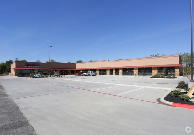
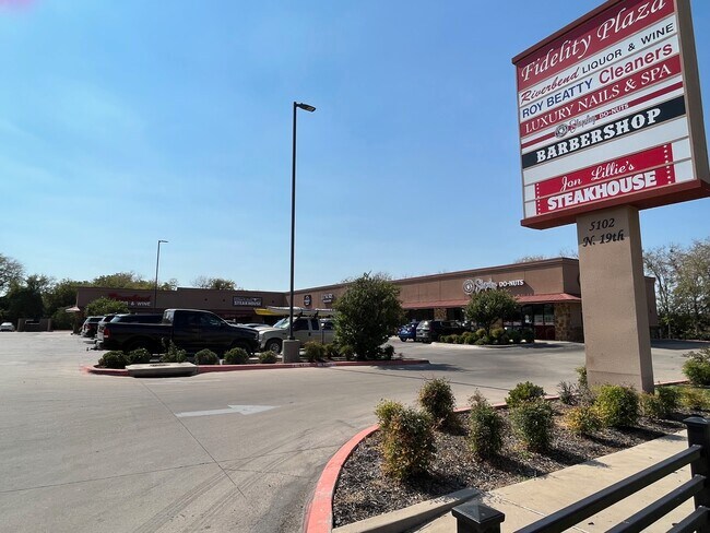
Property Record
5102 N 19Th St, Waco, TX 76708

Property Detail
5102 N 19Th St
48-039025-000200-0
STRAUSBURGER TRUST LOT 2A BLOCK 1 ACRES 1.2163
Commercialnec
McLennan
C-2
Texas
C and X Area of minimal flood hazard, usually depicted on FIRMs as above the 500-year flood level.
2a
2024
1.22 AC
2025
Waco
003000
Other Market Areas
15,200 SF
Waco, TX
NEARBY LISTINGS FOR SALE OR LEASE
DEMOGRAPHICS near 5102 N 19Th St
1 mile
3 mile
5 mile
2025 Total Population
3,090
27,011
88,567
2030 Population
3,175
27,777
91,607
Pop Growth 2025-2030
+ 2.75%
+ 2.84%
+ 3.43%
Average Age
42
38
37
2025 Total Households
1,502
10,432
34,350
HH Growth 2025-2030
+ 2.53%
+ 2.73%
+ 3.42%
Median Household Inc
$40,326
$52,592
$50,520
Avg Household Size
1.90
2.50
2.50
2025 Avg HH Vehicles
1.00
2.00
2.00
Median Home Value
$235,952
$227,024
$216,498
Median Year Built
1975
1968
1970
Nearby Places
Map Layers
Map Styles
 Street
 Aerial
Transit
 Traffic
 Biking
Places
Listings with unknown addresses are not visible on the map
- Restaurants
- Banks
- Shops
- Fitness
- Groceries
PUBLIC TRANSPORTATION
AIRPORT
Waco Regional
Drive
Walk
Distance
Waco Regional
11 min
4.3 mi
Freight Ports
Port of Houston
Drive
Walk
Distance
Port of Houston
222 min
191.8 mi
SALE & LEASE HISTORY
LISTING DATE
SALE/LEASE

Oct 12, 2022
For Lease
Nov 04, 2016
For Lease
May 07, 2018
For Lease
Nearby Properties
Address
Land Use
TOTAL SIZE
Lot Size
Zoning
Address
Land Use
TOTAL SIZE
Lot Size
Zoning
214,351 SF
19.37 AC
R3B
Address
Land Use
TOTAL SIZE
Lot Size
Zoning
346,987 SF
146.01 AC
C
Address
Land Use
TOTAL SIZE
Lot Size
Zoning
189,996 SF
13.98 AC
O2
Address
Land Use
TOTAL SIZE
Lot Size
Zoning
167,206 SF
11.22 AC
R-3C
Address
Land Use
TOTAL SIZE
Lot Size
Zoning
238,580 SF
12.25 AC
R-3E
Address
Land Use
TOTAL SIZE
Lot Size
Zoning
32,870 SF
100 AC
TIF3
Address
Land Use
TOTAL SIZE
Lot Size
Zoning
111,840 SF
38.94 AC
R1B
Address
Land Use
TOTAL SIZE
Lot Size
Zoning
158,050 SF
17.19 AC
R-2
Address
Land Use
TOTAL SIZE
Lot Size
Zoning
137,233 SF
3.51 AC
O2
Address
Land Use
TOTAL SIZE
Lot Size
Zoning
61,752 SF
3.68 AC
C2
Address
Land Use
TOTAL SIZE
Lot Size
Zoning
127,586 SF
12.78 AC
R-3B
Address
Land Use
TOTAL SIZE
Lot Size
Zoning
3.12 AC
R3D
Address
Land Use
TOTAL SIZE
Lot Size
Zoning
11,487 SF
85.25 AC
R
Address
Land Use
TOTAL SIZE
Lot Size
Zoning
69,642 SF
27.76 AC
R1B
Address
Land Use
TOTAL SIZE
Lot Size
Zoning
95,336 SF
4.06 AC
R3E
Address
Land Use
TOTAL SIZE
Lot Size
Zoning
52,472 SF
2.22 AC
2
Address
Land Use
TOTAL SIZE
Lot Size
Zoning
42,983 SF
9.41 AC
R1B
Address
Land Use
TOTAL SIZE
Lot Size
Zoning
104,472 SF
5.95 AC
O3
Address
Land Use
TOTAL SIZE
Lot Size
Zoning
111,212 SF
3.02 AC
O3
Address
Land Use
TOTAL SIZE
Lot Size
Zoning
40,889 SF
6.78 AC
R1A
Address
Land Use
TOTAL SIZE
Lot Size
Zoning
129,138 SF
53.11 AC
R1B
Address
Land Use
TOTAL SIZE
Lot Size
Zoning
7,020 SF
71.49 AC
R1B
Address
Land Use
TOTAL SIZE
Lot Size
Zoning
7,020 SF
71.30 AC
R1B
Address
Land Use
TOTAL SIZE
Lot Size
Zoning
5,654 SF
2.33 AC
Address
Land Use
TOTAL SIZE
Lot Size
Zoning
55,862 SF
13.88 AC
R1B
Address
Land Use
TOTAL SIZE
Lot Size
Zoning
51,356 SF
6.27 AC
R1B
Address
Land Use
TOTAL SIZE
Lot Size
Zoning
14,769 SF
2.61 AC
C-2
Address
Land Use
TOTAL SIZE
Lot Size
Zoning
46,543 SF
5.38 AC
O-3
Address
Land Use
TOTAL SIZE
Lot Size
Zoning
56,732 SF
10.70 AC
R
Address
Land Use
TOTAL SIZE
Lot Size
Zoning
65,309 SF
2.08 AC
O3
The World's #1 Commercial Real Estate Marketplace
Connect with us
© 2026 CoStar Group
The information above has been obtained from sources believed reliable. While we do not doubt its accuracy we have not verified it and make no guarantee, warranty or representation about it. It is your responsibility to independently confirm its accuracy and completeness. Any projections, opinions, assumptions, or estimates used are for example only and do not represent the current or future performance of the property. The value of this transaction to you depends on tax and other factors which should be evaluated by your tax, financial, and legal advisors. You and your advisors should conduct a careful, independent investigation of the property to determine to your satisfaction the suitability of the property for your needs.