Property Record
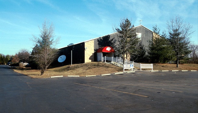
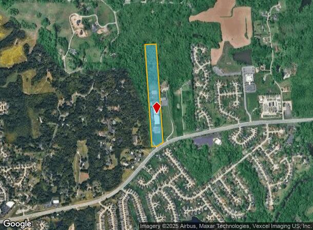
5105 N Highway 67, Florissant, MO 63034
This Property Is For Sale
NEARBY LISTINGS FOR SALE OR LEASE
-
-
View all Florissant listings for sale on LoopNet.com
Property Detail
5105 N Highway 67
06G-54-0044
Us Surv 210
Warehouse
SURVEY 210-47-7
X
St. Louis
29183C0325G
Missouri
2024
13.82 AC
2025
North County
210912
St. Louis
51,426 SF
St. Louis, MO-IL
DEMOGRAPHICS near 5105 N Highway 67
1 Mile
3 Mile
5 Mile
2024 Total Population
3,444
49,127
139,063
2029 Population
3,357
48,092
136,901
Pop Growth 2024-2029
(2.53%)
(2.11%)
(1.55%)
Average Age
44
42
40
2024 Total Households
1,358
19,047
54,289
HH Growth 2024-2029
(2.58%)
(2.12%)
(1.59%)
Median Household Inc
$94,748
$74,602
$58,508
Avg Household Size
2.50
2.50
2.50
2024 Avg HH Vehicles
2.00
2.00
2.00
Median Home Value
$179,526
$161,120
$144,050
Median Year Built
1987
1971
1966
Nearby Places
Map Layers
Map Styles
 Street
 Aerial
- Restaurants
- Banks
- Shops
- Fitness
- Groceries
PUBLIC TRANSPORTATION
AIRPORT
St Louis Lambert International
DRIVE
WALK
Distance
St Louis Lambert International
18 min
8.5 mi
Scott AFB/Midamerica St Louis
DRIVE
WALK
Distance
Scott AFB/Midamerica St Louis
62 min
40.2 mi
Nearby Properties
Address
Land Use
TOTAL SIZE
Lot Size
Zoning
Address
Land Use
TOTAL SIZE
Lot Size
Zoning
47,184 SF
71.66 AC
R4
Address
Land Use
TOTAL SIZE
Lot Size
Zoning
71.29 AC
24R4
Address
Land Use
TOTAL SIZE
Lot Size
Zoning
15.37 AC
R
Address
Land Use
TOTAL SIZE
Lot Size
Zoning
271,184 SF
13.67 AC
B3
Address
Land Use
TOTAL SIZE
Lot Size
Zoning
93,136 SF
108.76 AC
Address
Land Use
TOTAL SIZE
Lot Size
Zoning
354,790 SF
22.46 AC
B6
Address
Land Use
TOTAL SIZE
Lot Size
Zoning
1,294,178 SF
142.42 AC
C-8
Address
Land Use
TOTAL SIZE
Lot Size
Zoning
21.29 AC
24R4
Address
Land Use
TOTAL SIZE
Lot Size
Zoning
2,429 SF
79.10 AC
NU
Address
Land Use
TOTAL SIZE
Lot Size
Zoning
293,117 SF
26 AC
R3
Address
Land Use
TOTAL SIZE
Lot Size
Zoning
169,426 SF
26.38 AC
R1
Address
Land Use
TOTAL SIZE
Lot Size
Zoning
50.71 AC
R3D
Address
Land Use
TOTAL SIZE
Lot Size
Zoning
47,184 SF
119.33 AC
PS
Address
Land Use
TOTAL SIZE
Lot Size
Zoning
1,560 SF
12.84 AC
R4
Address
Land Use
TOTAL SIZE
Lot Size
Zoning
193,344 SF
14.37 AC
24MFD
Address
Land Use
TOTAL SIZE
Lot Size
Zoning
231.84 AC
NU
Address
Land Use
TOTAL SIZE
Lot Size
Zoning
12.83 AC
24R4
Address
Land Use
TOTAL SIZE
Lot Size
Zoning
146,186 SF
8.24 AC
R4
Address
Land Use
TOTAL SIZE
Lot Size
Zoning
1,797 SF
23.66 AC
NU
Address
Land Use
TOTAL SIZE
Lot Size
Zoning
106,935 SF
8.25 AC
24B5
Address
Land Use
TOTAL SIZE
Lot Size
Zoning
179,262 SF
9.58 AC
R2
Address
Land Use
TOTAL SIZE
Lot Size
Zoning
Address
Land Use
TOTAL SIZE
Lot Size
Zoning
16.58 AC
24R4
Address
Land Use
TOTAL SIZE
Lot Size
Zoning
136,874 SF
13.18 AC
R1
Address
Land Use
TOTAL SIZE
Lot Size
Zoning
7.99 AC
103R-1
Address
Land Use
TOTAL SIZE
Lot Size
Zoning
120.20 AC
PS
Address
Land Use
TOTAL SIZE
Lot Size
Zoning
121,945 SF
10.10 AC
24B5
Address
Land Use
TOTAL SIZE
Lot Size
Zoning
14.23 AC
24R4
Address
Land Use
TOTAL SIZE
Lot Size
Zoning
87,459 SF
41.15 AC
A
Address
Land Use
TOTAL SIZE
Lot Size
Zoning
7.19 AC
NU
The World's #1 Commercial Real Estate Marketplace
Connect with us
© 2026 CoStar Group
The information above has been obtained from sources believed reliable. While we do not doubt its accuracy we have not verified it and make no guarantee, warranty or representation about it. It is your responsibility to independently confirm its accuracy and completeness. Any projections, opinions, assumptions, or estimates used are for example only and do not represent the current or future performance of the property. The value of this transaction to you depends on tax and other factors which should be evaluated by your tax, financial, and legal advisors. You and your advisors should conduct a careful, independent investigation of the property to determine to your satisfaction the suitability of the property for your needs.