Property Record
5107 Cedar Dr, Colcord, OK 74338
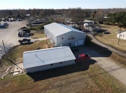

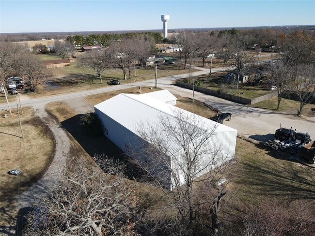
Property Detail
5107 Cedar Dr
0030599
36-20-25 PT W2 W2 NE NW 1.24 AC BEG NW COR W2 W2 NE NW; E 180' S 300'; W 180'; N 300' TO BEG 2308-643 2397-328
Storebuilding
Delaware
B and X Area of moderate flood hazard, usually the area between the limits of the 100-year and 500-year floods.
Oklahoma
2025
1.24 AC
2025
Oklahoma East Area
976200
Other Market Areas
1,800 SF
NEARBY LISTINGS FOR SALE OR LEASE
DEMOGRAPHICS near 5107 Cedar Dr
1 mile
3 mile
5 mile
2025 Total Population
556
8,235
24,553
2030 Population
541
8,838
26,997
Pop Growth 2025-2030
(2.70%)
+ 7.32%
+ 9.95%
Average Age
40
36
37
2025 Total Households
194
2,753
8,536
HH Growth 2025-2030
(3.61%)
+ 7.34%
+ 10.16%
Median Household Inc
$55,999
$60,598
$67,888
Avg Household Size
2.70
2.60
2.70
2025 Avg HH Vehicles
2.00
2.00
2.00
Median Home Value
$176,922
$226,119
$247,638
Median Year Built
1988
1985
1994
Nearby Places
Map Layers
Map Styles
 Street
 Aerial
Layers
 Traffic
 Biking
Places
Listings with unknown addresses are not visible on the map
- Restaurants
- Banks
- Shops
- Fitness
- Groceries
PUBLIC TRANSPORTATION
AIRPORT
Northwest Arkansas Ntl
Drive
Walk
Distance
Northwest Arkansas Ntl
43 min
26.8 mi
SALE & LEASE HISTORY
LISTING DATE
SALE/LEASE

Feb 23, 2023
For Sale
Nearby Properties
Address
Land Use
TOTAL SIZE
Lot Size
Zoning
Address
Land Use
TOTAL SIZE
Lot Size
Zoning
85,903 SF
10 AC
Address
Land Use
TOTAL SIZE
Lot Size
Zoning
53,071 SF
2.07 AC
Address
Land Use
TOTAL SIZE
Lot Size
Zoning
41,748 SF
5.44 AC
Address
Land Use
TOTAL SIZE
Lot Size
Zoning
20,714 SF
0.57 AC
Address
Land Use
TOTAL SIZE
Lot Size
Zoning
40,709 SF
4.24 AC
Address
Land Use
TOTAL SIZE
Lot Size
Zoning
244,674 SF
18.51 AC
Address
Land Use
TOTAL SIZE
Lot Size
Zoning
23,918 SF
1.95 AC
Address
Land Use
TOTAL SIZE
Lot Size
Zoning
16,250 SF
4.57 AC
Address
Land Use
TOTAL SIZE
Lot Size
Zoning
36,126 SF
1.97 AC
Address
Land Use
TOTAL SIZE
Lot Size
Zoning
7,160 SF
2.05 AC
Address
Land Use
TOTAL SIZE
Lot Size
Zoning
88,576 SF
4.45 AC
Address
Land Use
TOTAL SIZE
Lot Size
Zoning
46,882 SF
7.62 AC
Address
Land Use
TOTAL SIZE
Lot Size
Zoning
6,547 SF
2.19 AC
Address
Land Use
TOTAL SIZE
Lot Size
Zoning
Address
Land Use
TOTAL SIZE
Lot Size
Zoning
14,729 SF
1.87 AC
Address
Land Use
TOTAL SIZE
Lot Size
Zoning
14,540 SF
Address
Land Use
TOTAL SIZE
Lot Size
Zoning
4,716 SF
0.02 AC
Address
Land Use
TOTAL SIZE
Lot Size
Zoning
21,532 SF
3.38 AC
Address
Land Use
TOTAL SIZE
Lot Size
Zoning
6,694 SF
1.24 AC
Address
Land Use
TOTAL SIZE
Lot Size
Zoning
38,640 SF
1.28 AC
Address
Land Use
TOTAL SIZE
Lot Size
Zoning
14,056 SF
0.72 AC
Address
Land Use
TOTAL SIZE
Lot Size
Zoning
16,660 SF
0.96 AC
Address
Land Use
TOTAL SIZE
Lot Size
Zoning
12,717 SF
3.57 AC
Address
Land Use
TOTAL SIZE
Lot Size
Zoning
12,088 SF
1.14 AC
Address
Land Use
TOTAL SIZE
Lot Size
Zoning
10,344 SF
1.36 AC
Address
Land Use
TOTAL SIZE
Lot Size
Zoning
25,190 SF
4.56 AC
Address
Land Use
TOTAL SIZE
Lot Size
Zoning
4,464 SF
1.29 AC
Address
Land Use
TOTAL SIZE
Lot Size
Zoning
9,852 SF
0.70 AC
Address
Land Use
TOTAL SIZE
Lot Size
Zoning
27,968 SF
2.12 AC
The World's #1 Commercial Real Estate Marketplace
Connect with us
© 2026 CoStar Group
The information above has been obtained from sources believed reliable. While we do not doubt its accuracy we have not verified it and make no guarantee, warranty or representation about it. It is your responsibility to independently confirm its accuracy and completeness. Any projections, opinions, assumptions, or estimates used are for example only and do not represent the current or future performance of the property. The value of this transaction to you depends on tax and other factors which should be evaluated by your tax, financial, and legal advisors. You and your advisors should conduct a careful, independent investigation of the property to determine to your satisfaction the suitability of the property for your needs.