Property Record
511 Broad St, Chattanooga, TN 37402

Save to a Folder
{{folder.Name}}
{{folder.ListingIds.length}} Properties
{{folder.ListingIds.length}} Property
Create a New Folder
Property Detail
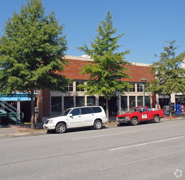
511 Broad St
135NC-B-002
PT LTS 34&36 ORIGINAL TOWN CHESTNUT ST N/R
Restaurantbuilding
Hamilton
C3
Tennessee
B and X Area of moderate flood hazard, usually the area between the limits of the 100-year and 500-year floods.
34,36
2025
0.54 AC
2025
CBD
003100
Chattanooga
19,603 SF
Chattanooga, TN-GA
NEARBY LISTINGS FOR SALE OR LEASE
DEMOGRAPHICS near 511 Broad St
1 mile
3 mile
5 mile
2025 Total Population
10,532
53,330
123,891
2030 Population
11,250
57,046
131,418
Pop Growth 2025-2030
+ 6.82%
+ 6.97%
+ 6.08%
Average Age
37
37
38
2025 Total Households
5,322
23,639
53,243
HH Growth 2025-2030
+ 7.63%
+ 7.34%
+ 6.34%
Median Household Inc
$46,189
$63,287
$60,120
Avg Household Size
1.60
2.10
2.20
2025 Avg HH Vehicles
1.00
1.00
2.00
Median Home Value
$546,385
$400,251
$309,952
Median Year Built
1984
1977
1968
Nearby Places
Map Layers
Map Styles
 Street
 Aerial
Layers
 Traffic
 Biking
Places
Listings with unknown addresses are not visible on the map
- Restaurants
- Banks
- Shops
- Fitness
- Groceries
PUBLIC TRANSPORTATION
AIRPORT
Lovell Field
Drive
Walk
Distance
Lovell Field
21 min
8.5 mi
SALE & LEASE HISTORY
LISTING DATE
SALE/LEASE

Jun 17, 2021
For Lease
Nearby Properties
Address
Land Use
TOTAL SIZE
Lot Size
Zoning
Address
Land Use
TOTAL SIZE
Lot Size
Zoning
1,412,692 SF
1.74 AC
C3
Address
Land Use
TOTAL SIZE
Lot Size
Zoning
1,750,017 SF
31.32 AC
Address
Land Use
TOTAL SIZE
Lot Size
Zoning
603,035 SF
21.57 AC
C3
Address
Land Use
TOTAL SIZE
Lot Size
Zoning
308,910 SF
53.60 AC
M1
Address
Land Use
TOTAL SIZE
Lot Size
Zoning
6.35 AC
Address
Land Use
TOTAL SIZE
Lot Size
Zoning
252,201 SF
1.60 AC
C3
Address
Land Use
TOTAL SIZE
Lot Size
Zoning
293,884 SF
4.40 AC
Address
Land Use
TOTAL SIZE
Lot Size
Zoning
192,000 SF
3.09 AC
R4
Address
Land Use
TOTAL SIZE
Lot Size
Zoning
409,451 SF
2.53 AC
C3
Address
Land Use
TOTAL SIZE
Lot Size
Zoning
298,706 SF
1.18 AC
Address
Land Use
TOTAL SIZE
Lot Size
Zoning
91,908 SF
2.64 AC
C3
Address
Land Use
TOTAL SIZE
Lot Size
Zoning
552,237 SF
1.87 AC
Address
Land Use
TOTAL SIZE
Lot Size
Zoning
170,000 SF
2.25 AC
C3
Address
Land Use
TOTAL SIZE
Lot Size
Zoning
182,932 SF
3.67 AC
M1
Address
Land Use
TOTAL SIZE
Lot Size
Zoning
134,974 SF
3.22 AC
Address
Land Use
TOTAL SIZE
Lot Size
Zoning
306,411 SF
6.96 AC
Address
Land Use
TOTAL SIZE
Lot Size
Zoning
19.38 AC
M1
Address
Land Use
TOTAL SIZE
Lot Size
Zoning
351,776 SF
17.70 AC
R4
Address
Land Use
TOTAL SIZE
Lot Size
Zoning
308,635 SF
2.24 AC
M1
Address
Land Use
TOTAL SIZE
Lot Size
Zoning
105,125 SF
3.38 AC
Address
Land Use
TOTAL SIZE
Lot Size
Zoning
275,364 SF
16.86 AC
C2
Address
Land Use
TOTAL SIZE
Lot Size
Zoning
357,029 SF
13.45 AC
C3
Address
Land Use
TOTAL SIZE
Lot Size
Zoning
293,516 SF
5.12 AC
M1
Address
Land Use
TOTAL SIZE
Lot Size
Zoning
194,019 SF
1.46 AC
C3
Address
Land Use
TOTAL SIZE
Lot Size
Zoning
288,371 SF
9.39 AC
Address
Land Use
TOTAL SIZE
Lot Size
Zoning
96,222 SF
0.57 AC
C3
Address
Land Use
TOTAL SIZE
Lot Size
Zoning
171,906 SF
2.10 AC
C2
Address
Land Use
TOTAL SIZE
Lot Size
Zoning
291,600 SF
1.32 AC
Address
Land Use
TOTAL SIZE
Lot Size
Zoning
175,260 SF
2.75 AC
C3
Address
Land Use
TOTAL SIZE
Lot Size
Zoning
75,697 SF
1.33 AC
The World's #1 Commercial Real Estate Marketplace
Connect with us
© 2026 CoStar Group
The information above has been obtained from sources believed reliable. While we do not doubt its accuracy we have not verified it and make no guarantee, warranty or representation about it. It is your responsibility to independently confirm its accuracy and completeness. Any projections, opinions, assumptions, or estimates used are for example only and do not represent the current or future performance of the property. The value of this transaction to you depends on tax and other factors which should be evaluated by your tax, financial, and legal advisors. You and your advisors should conduct a careful, independent investigation of the property to determine to your satisfaction the suitability of the property for your needs.