Property Record
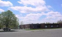
511 E 12Th St E, Riverton, WY 82501

Property Detail
511 E 12Th St E
9114-26-3-71-001.00
TWELFTH STREET PROFESSIONAL BUILDING BLK 1 LOT 1 WD 2016-1391254
Officebuilding
Fremont
B and X Area of moderate flood hazard, usually the area between the limits of the 100-year and 500-year floods.
Wyoming
2024
1
2025
1.70 AC
940400
Other Market Areas
23,953 SF
Riverton, WY
NEARBY LISTINGS FOR SALE OR LEASE
DEMOGRAPHICS near 511 E 12Th St E
1 mile
3 mile
5 mile
2025 Total Population
6,742
12,900
15,482
2030 Population
6,889
13,170
15,759
Pop Growth 2025-2030
+ 2.18%
+ 2.09%
+ 1.79%
Average Age
39
40
40
2025 Total Households
2,828
5,123
5,993
HH Growth 2025-2030
+ 1.87%
+ 1.78%
+ 1.55%
Median Household Inc
$53,750
$54,185
$56,028
Avg Household Size
2.30
2.40
2.40
2025 Avg HH Vehicles
2.00
2.00
2.00
Median Home Value
$169,926
$209,945
$225,020
Median Year Built
1969
1974
1976
Nearby Places
Map Layers
Map Styles
 Street
 Aerial
Transit
 Traffic
 Biking
Places
Listings with unknown addresses are not visible on the map
- Restaurants
- Banks
- Shops
- Fitness
- Groceries
Nearby Properties
Address
Land Use
TOTAL SIZE
Lot Size
Zoning
Address
Land Use
TOTAL SIZE
Lot Size
Zoning
81,455 SF
10.48 AC
Address
Land Use
TOTAL SIZE
Lot Size
Zoning
191,445 SF
10.25 AC
Address
Land Use
TOTAL SIZE
Lot Size
Zoning
57,396 SF
3.22 AC
Address
Land Use
TOTAL SIZE
Lot Size
Zoning
73,211 SF
4.79 AC
Address
Land Use
TOTAL SIZE
Lot Size
Zoning
95,845 SF
8.75 AC
Address
Land Use
TOTAL SIZE
Lot Size
Zoning
61,756 SF
3 AC
Address
Land Use
TOTAL SIZE
Lot Size
Zoning
50,896 SF
4.06 AC
Address
Land Use
TOTAL SIZE
Lot Size
Zoning
33,430 SF
4.06 AC
Address
Land Use
TOTAL SIZE
Lot Size
Zoning
32,673 SF
5 AC
Address
Land Use
TOTAL SIZE
Lot Size
Zoning
32,770 SF
4.02 AC
Address
Land Use
TOTAL SIZE
Lot Size
Zoning
35,480 SF
Address
Land Use
TOTAL SIZE
Lot Size
Zoning
43,202 SF
3.37 AC
Address
Land Use
TOTAL SIZE
Lot Size
Zoning
51,690 SF
3.37 AC
Address
Land Use
TOTAL SIZE
Lot Size
Zoning
52,749 SF
3.29 AC
Address
Land Use
TOTAL SIZE
Lot Size
Zoning
24,828 SF
10 AC
Address
Land Use
TOTAL SIZE
Lot Size
Zoning
10,134 SF
1 AC
Address
Land Use
TOTAL SIZE
Lot Size
Zoning
22,236 SF
4 AC
Address
Land Use
TOTAL SIZE
Lot Size
Zoning
43,400 SF
2.80 AC
Address
Land Use
TOTAL SIZE
Lot Size
Zoning
28,416 SF
1.60 AC
Address
Land Use
TOTAL SIZE
Lot Size
Zoning
26,809 SF
0.80 AC
Address
Land Use
TOTAL SIZE
Lot Size
Zoning
34,920 SF
2.63 AC
Address
Land Use
TOTAL SIZE
Lot Size
Zoning
22,500 SF
2.87 AC
Address
Land Use
TOTAL SIZE
Lot Size
Zoning
31,132 SF
0.32 AC
Address
Land Use
TOTAL SIZE
Lot Size
Zoning
15,528 SF
1.73 AC
Address
Land Use
TOTAL SIZE
Lot Size
Zoning
14,240 SF
11.43 AC
Address
Land Use
TOTAL SIZE
Lot Size
Zoning
33,762 SF
13.49 AC
Address
Land Use
TOTAL SIZE
Lot Size
Zoning
15,600 SF
0.95 AC
Address
Land Use
TOTAL SIZE
Lot Size
Zoning
32,077 SF
2.05 AC
Address
Land Use
TOTAL SIZE
Lot Size
Zoning
13,117 SF
1.62 AC
The World's #1 Commercial Real Estate Marketplace
Connect with us
© 2026 CoStar Group
The information above has been obtained from sources believed reliable. While we do not doubt its accuracy we have not verified it and make no guarantee, warranty or representation about it. It is your responsibility to independently confirm its accuracy and completeness. Any projections, opinions, assumptions, or estimates used are for example only and do not represent the current or future performance of the property. The value of this transaction to you depends on tax and other factors which should be evaluated by your tax, financial, and legal advisors. You and your advisors should conduct a careful, independent investigation of the property to determine to your satisfaction the suitability of the property for your needs.