Property Record
511 Edgar Rd, Elizabeth, NJ 07202
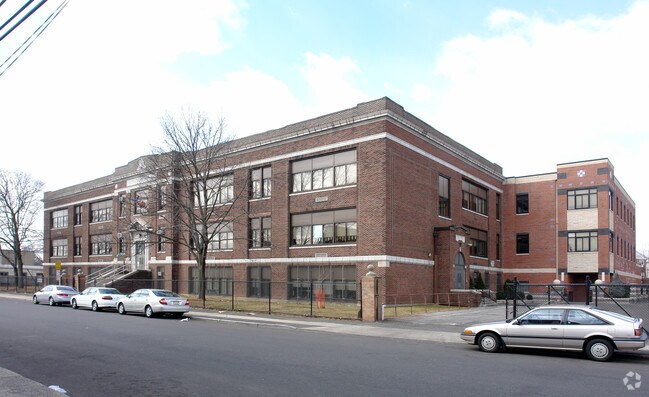


Property Detail
511 Edgar Rd
Newark, NJ
FACILITY NAME: SCHOOLS
04-00004-0000-00398
UNION
Publicschool
New Jersey
R2
19
B and X Area of moderate flood hazard, usually the area between the limits of the 100-year and 500-year floods.
2.33 AC
0
Parkway Cranford Corridor
2025
Northern New Jersey
030703
NEARBY LISTINGS FOR SALE OR LEASE
DEMOGRAPHICS near 511 Edgar Rd
1 mile
3 mile
5 mile
2025 Total Population
45,938
233,843
530,700
2030 Population
46,971
241,445
546,383
Pop Growth 2025-2030
+ 2.25%
+ 3.25%
+ 2.96%
Average Age
39
39
39
2025 Total Households
16,036
81,042
185,157
HH Growth 2025-2030
+ 2.48%
+ 3.51%
+ 3.18%
Median Household Inc
$71,113
$77,064
$82,902
Avg Household Size
2.70
2.80
2.80
2025 Avg HH Vehicles
1.00
1.00
2.00
Median Home Value
$432,605
$433,797
$462,455
Median Year Built
1958
1956
1957
Nearby Places
Map Layers
Map Styles
 Street
 Aerial
Layers
 Traffic
 Biking
Places
Listings with unknown addresses are not visible on the map
- Restaurants
- Banks
- Shops
- Fitness
- Groceries
PUBLIC TRANSPORTATION
COMMUTER RAIL
Elizabeth (North Jersey Coast Line - NJ Transit Commuter Rail (NJ Transit), Northeast Corridor Line - NJ Transit Commuter Rail (NJ Transit))
Drive
Walk
Distance
Elizabeth (North Jersey Coast Line - NJ Transit Commuter Rail (NJ Transit), Northeast Corridor Line - NJ Transit Commuter Rail (NJ Transit))
5 min
1.4 mi
Linden (North Jersey Coast Line - NJ Transit Commuter Rail (NJ Transit), Northeast Corridor Line - NJ Transit Commuter Rail (NJ Transit))
Drive
Walk
Distance
Linden (North Jersey Coast Line - NJ Transit Commuter Rail (NJ Transit), Northeast Corridor Line - NJ Transit Commuter Rail (NJ Transit))
6 min
2.8 mi
AIRPORT
Newark Liberty International
Drive
Walk
Distance
Newark Liberty International
13 min
7.9 mi
LaGuardia
Drive
Walk
Distance
LaGuardia
48 min
25.6 mi
John F Kennedy International
Drive
Walk
Distance
John F Kennedy International
52 min
31.4 mi
Freight Ports
New York Container Terminal
Drive
Walk
Distance
New York Container Terminal
10 min
4.2 mi
Nearby Properties
Address
Land Use
TOTAL SIZE
Lot Size
Zoning
Address
Land Use
TOTAL SIZE
Lot Size
Zoning
Address
Land Use
TOTAL SIZE
Lot Size
Zoning
Address
Land Use
TOTAL SIZE
Lot Size
Zoning
Address
Land Use
TOTAL SIZE
Lot Size
Zoning
28.40 AC
Address
Land Use
TOTAL SIZE
Lot Size
Zoning
11.36 AC
Address
Land Use
TOTAL SIZE
Lot Size
Zoning
Address
Land Use
TOTAL SIZE
Lot Size
Zoning
Address
Land Use
TOTAL SIZE
Lot Size
Zoning
Address
Land Use
TOTAL SIZE
Lot Size
Zoning
5.89 AC
Address
Land Use
TOTAL SIZE
Lot Size
Zoning
Address
Land Use
TOTAL SIZE
Lot Size
Zoning
16.63 AC
Address
Land Use
TOTAL SIZE
Lot Size
Zoning
2.21 AC
Address
Land Use
TOTAL SIZE
Lot Size
Zoning
149.68 AC
Address
Land Use
TOTAL SIZE
Lot Size
Zoning
Address
Land Use
TOTAL SIZE
Lot Size
Zoning
51.62 AC
Address
Land Use
TOTAL SIZE
Lot Size
Zoning
20,000 SF
30.36 AC
Address
Land Use
TOTAL SIZE
Lot Size
Zoning
91,760 SF
210.43 AC
M3-1
Address
Land Use
TOTAL SIZE
Lot Size
Zoning
Address
Land Use
TOTAL SIZE
Lot Size
Zoning
1.89 AC
Address
Land Use
TOTAL SIZE
Lot Size
Zoning
Address
Land Use
TOTAL SIZE
Lot Size
Zoning
3,500,000 SF
11.97 AC
MRC2
Address
Land Use
TOTAL SIZE
Lot Size
Zoning
2.21 AC
Address
Land Use
TOTAL SIZE
Lot Size
Zoning
51.61 AC
Address
Land Use
TOTAL SIZE
Lot Size
Zoning
39.64 AC
Address
Land Use
TOTAL SIZE
Lot Size
Zoning
6,188,000 SF
8.18 AC
Address
Land Use
TOTAL SIZE
Lot Size
Zoning
11.96 AC
Address
Land Use
TOTAL SIZE
Lot Size
Zoning
12.46 AC
Address
Land Use
TOTAL SIZE
Lot Size
Zoning
1,073 SF
2.63 AC
Address
Land Use
TOTAL SIZE
Lot Size
Zoning
1 SF
20 AC
Address
Land Use
TOTAL SIZE
Lot Size
Zoning
0.83 AC
The World's #1 Commercial Real Estate Marketplace
Connect with us
© 2026 CoStar Group
The information above has been obtained from sources believed reliable. While we do not doubt its accuracy we have not verified it and make no guarantee, warranty or representation about it. It is your responsibility to independently confirm its accuracy and completeness. Any projections, opinions, assumptions, or estimates used are for example only and do not represent the current or future performance of the property. The value of this transaction to you depends on tax and other factors which should be evaluated by your tax, financial, and legal advisors. You and your advisors should conduct a careful, independent investigation of the property to determine to your satisfaction the suitability of the property for your needs.