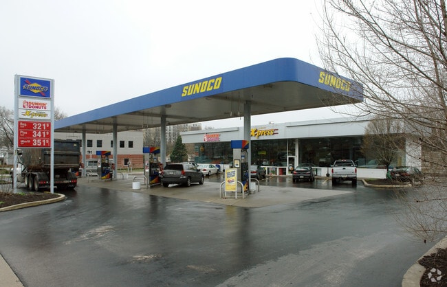
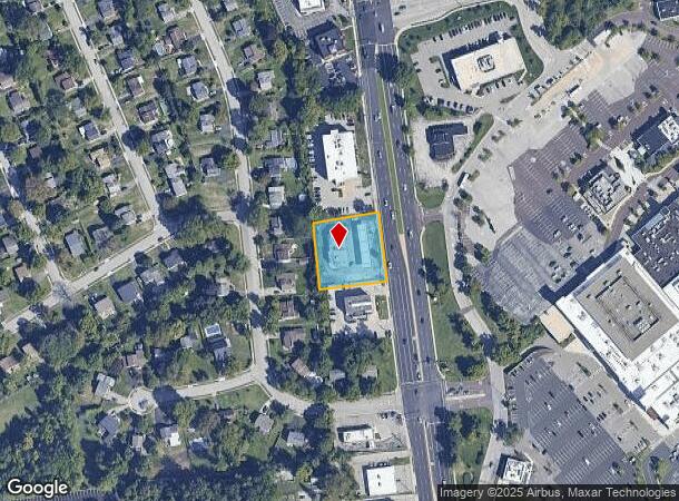
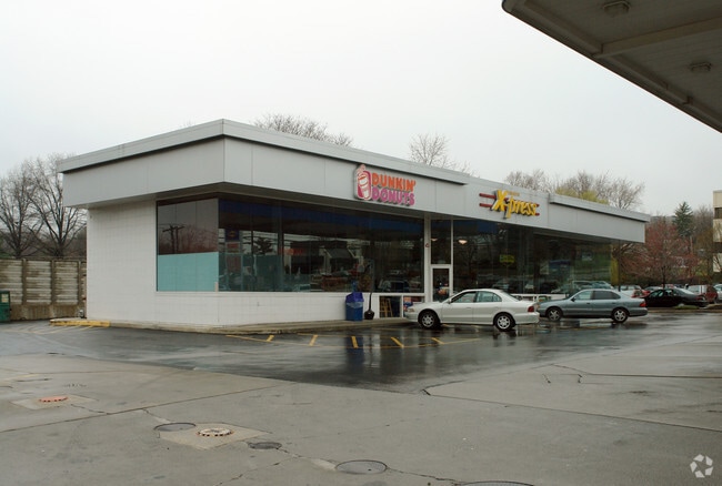
Property Record
511 W Germantown Pike, Norristown, PA 19403
NEARBY LISTINGS FOR SALE OR LEASE
Property Detail
511 W Germantown Pike
Philadelphia-Camden-Wilmington, PA-NJ-DE-MD
Alta/Acsm Land Title Un 121 Su
49-00-04339-004
AS
Servicestationmarket
Montgomery
X
Pennsylvania
42091C0356G
121
2024
0.74 AC
2025
Plymouth Mtg/Blue Bell
203302
Philadelphia
7,946 SF
DEMOGRAPHICS near 511 W Germantown Pike
1 Mile
3 Mile
5 Mile
2024 Total Population
7,557
79,700
189,281
2029 Population
7,856
81,458
192,644
Pop Growth 2024-2029
+ 3.96%
+ 2.21%
+ 1.78%
Average Age
42
40
41
2024 Total Households
3,153
31,740
75,142
HH Growth 2024-2029
+ 4.09%
+ 2.20%
+ 1.79%
Median Household Inc
$127,306
$98,345
$97,238
Avg Household Size
2.30
2.40
2.40
2024 Avg HH Vehicles
2.00
2.00
2.00
Median Home Value
$442,495
$383,738
$384,332
Median Year Built
1977
1966
1966
Nearby Places
Map Layers
Map Styles
 Street
 Aerial
- Restaurants
- Banks
- Shops
- Fitness
- Groceries
PUBLIC TRANSPORTATION
COMMUTER RAIL
Spring Mill (R6 - Southeastern Pennsylvania Transportation Authority Regional Rail (SEPTA Regional Rail))
DRIVE
WALK
Distance
Spring Mill (R6 - Southeastern Pennsylvania Transportation Authority Regional Rail (SEPTA Regional Rail))
8 min
3.6 mi
Norristown Transportation Center (R6 Line) (Manayunk/Norristown Line - SEPTA, R6 - SEPTA)
DRIVE
WALK
Distance
Norristown Transportation Center (R6 Line) (Manayunk/Norristown Line - SEPTA, R6 - SEPTA)
11 min
4.0 mi
AIRPORT
Philadelphia International
DRIVE
WALK
Distance
Philadelphia International
39 min
26.3 mi
Trenton Mercer
DRIVE
WALK
Distance
Trenton Mercer
46 min
35.4 mi
Freight Ports
Port of Philadelphia
DRIVE
WALK
Distance
Port of Philadelphia
32 min
18.2 mi
Nearby Properties
Address
Land Use
TOTAL SIZE
Lot Size
Zoning
Address
Land Use
TOTAL SIZE
Lot Size
Zoning
952,830 SF
95.86 AC
IAAA
Address
Land Use
TOTAL SIZE
Lot Size
Zoning
723,623 SF
6.69 AC
HVY
Address
Land Use
TOTAL SIZE
Lot Size
Zoning
510,312 SF
51.75 AC
IA
Address
Land Use
TOTAL SIZE
Lot Size
Zoning
469,066 SF
47 AC
MU
Address
Land Use
TOTAL SIZE
Lot Size
Zoning
476,392 SF
54.50 AC
I
Address
Land Use
TOTAL SIZE
Lot Size
Zoning
519,822 SF
19.53 AC
AR
Address
Land Use
TOTAL SIZE
Lot Size
Zoning
505,128 SF
12.11 AC
RE
Address
Land Use
TOTAL SIZE
Lot Size
Zoning
531,656 SF
19.51 AC
HVY
Address
Land Use
TOTAL SIZE
Lot Size
Zoning
217,564 SF
12.64 AC
IN
Address
Land Use
TOTAL SIZE
Lot Size
Zoning
231,665 SF
26.34 AC
OSR
Address
Land Use
TOTAL SIZE
Lot Size
Zoning
381,496 SF
5.37 AC
EC
Address
Land Use
TOTAL SIZE
Lot Size
Zoning
452,740 SF
11.03 AC
C
Address
Land Use
TOTAL SIZE
Lot Size
Zoning
310,900 SF
55.48 AC
HI
Address
Land Use
TOTAL SIZE
Lot Size
Zoning
320,804 SF
30.85 AC
CR
Address
Land Use
TOTAL SIZE
Lot Size
Zoning
512,846 SF
9.50 AC
HRA
Address
Land Use
TOTAL SIZE
Lot Size
Zoning
311,142 SF
39.51 AC
R1
Address
Land Use
TOTAL SIZE
Lot Size
Zoning
312,710 SF
30.07 AC
APTLR
Address
Land Use
TOTAL SIZE
Lot Size
Zoning
346,163 SF
16.53 AC
SC
Address
Land Use
TOTAL SIZE
Lot Size
Zoning
53,368 SF
38.59 AC
R3
Address
Land Use
TOTAL SIZE
Lot Size
Zoning
667,719 SF
23.73 AC
BP
Address
Land Use
TOTAL SIZE
Lot Size
Zoning
213,070 SF
29.67 AC
RE
Address
Land Use
TOTAL SIZE
Lot Size
Zoning
242,225 SF
9.16 AC
HVY
Address
Land Use
TOTAL SIZE
Lot Size
Zoning
227,948 SF
16 AC
AR
Address
Land Use
TOTAL SIZE
Lot Size
Zoning
208,144 SF
13.91 AC
AR
Address
Land Use
TOTAL SIZE
Lot Size
Zoning
186,736 SF
5.39 AC
AR
Address
Land Use
TOTAL SIZE
Lot Size
Zoning
205,344 SF
26.67 AC
RE
Address
Land Use
TOTAL SIZE
Lot Size
Zoning
747,448 SF
36.04 AC
SC
Address
Land Use
TOTAL SIZE
Lot Size
Zoning
153,544 SF
14.03 AC
I
Address
Land Use
TOTAL SIZE
Lot Size
Zoning
225,196 SF
14.87 AC
AR
Address
Land Use
TOTAL SIZE
Lot Size
Zoning
300,666 SF
14.33 AC
CR
The World's #1 Commercial Real Estate Marketplace
Connect with us
© 2025 CoStar Group
The information above has been obtained from sources believed reliable. While we do not doubt its accuracy we have not verified it and make no guarantee, warranty or representation about it. It is your responsibility to independently confirm its accuracy and completeness. Any projections, opinions, assumptions, or estimates used are for example only and do not represent the current or future performance of the property. The value of this transaction to you depends on tax and other factors which should be evaluated by your tax, financial, and legal advisors. You and your advisors should conduct a careful, independent investigation of the property to determine to your satisfaction the suitability of the property for your needs.