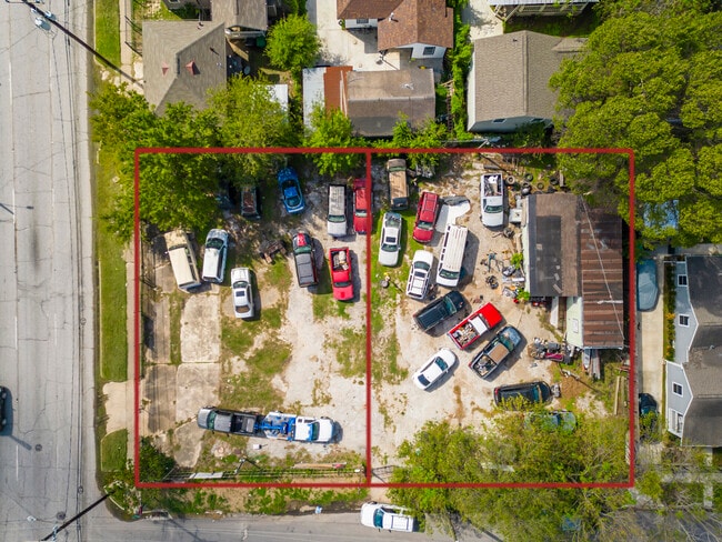
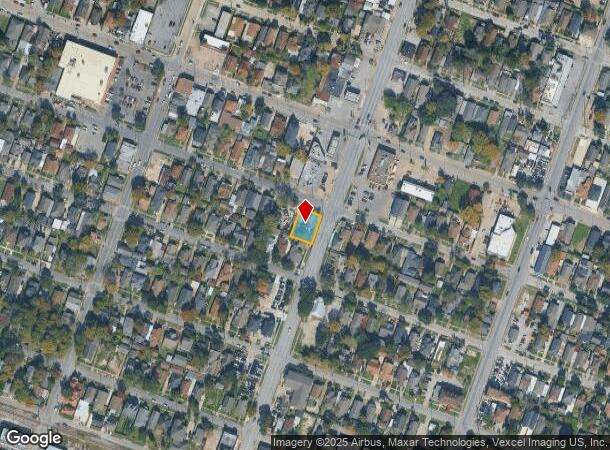
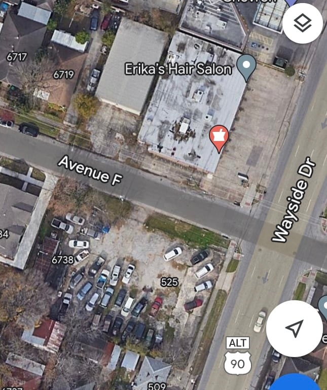
Property Record
511 Wayside Dr, Houston, TX 77011
NEARBY LISTINGS FOR SALE OR LEASE
Property Detail
511 Wayside Dr
Houston-The Woodlands-Sugar Land, TX
Central Park
0390260000044
LTS 46 47 & 48 BLK 44 CENTRAL PARK
Commercialnec
Harris
X
Texas
48201C0885N
46
2024
0.17 AC
2025
Gulf Freeway/Pasadena
310900
Houston
DEMOGRAPHICS near 511 Wayside Dr
1 Mile
3 Mile
5 Mile
2024 Total Population
16,596
120,107
345,967
2029 Population
17,089
123,952
357,979
Pop Growth 2024-2029
+ 2.97%
+ 3.20%
+ 3.47%
Average Age
38
37
37
2024 Total Households
5,882
42,631
128,951
HH Growth 2024-2029
+ 2.94%
+ 3.44%
+ 3.84%
Median Household Inc
$37,755
$41,326
$47,255
Avg Household Size
2.70
2.60
2.40
2024 Avg HH Vehicles
2.00
2.00
2.00
Median Home Value
$169,948
$176,364
$181,918
Median Year Built
1949
1956
1966
Nearby Places
Map Layers
Map Styles
 Street
 Aerial
- Restaurants
- Banks
- Shops
- Fitness
- Groceries
PUBLIC TRANSPORTATION
TRANSIT/SUBWAY
Cesar Chavez / 67Th St Eb (METRORAIL GREEN LINE - Metropolitan Transit Authority of Harris County)
DRIVE
WALK
Distance
Cesar Chavez / 67Th St Eb (METRORAIL GREEN LINE - Metropolitan Transit Authority of Harris County)
0 min
6 min
0.3 mi
Cesar Chavez / 67Th St Wb (METRORAIL GREEN LINE - Metropolitan Transit Authority of Harris County)
DRIVE
WALK
Distance
Cesar Chavez / 67Th St Wb (METRORAIL GREEN LINE - Metropolitan Transit Authority of Harris County)
1 min
7 min
0.4 mi
Magnolia Park Transit Center Wb (METRORAIL GREEN LINE - Metropolitan Transit Authority of Harris County)
DRIVE
WALK
Distance
Magnolia Park Transit Center Wb (METRORAIL GREEN LINE - Metropolitan Transit Authority of Harris County)
1 min
8 min
0.4 mi
Magnolia Park Transit Center Eb (METRORAIL GREEN LINE - Metropolitan Transit Authority of Harris County)
DRIVE
WALK
Distance
Magnolia Park Transit Center Eb (METRORAIL GREEN LINE - Metropolitan Transit Authority of Harris County)
1 min
8 min
0.4 mi
COMMUTER RAIL
Houston (Sunset Limited - Amtrak)
DRIVE
WALK
Distance
Houston (Sunset Limited - Amtrak)
10 min
5.0 mi
AIRPORT
William P Hobby
DRIVE
WALK
Distance
William P Hobby
19 min
9.3 mi
George Bush Intcntl/Houston
DRIVE
WALK
Distance
George Bush Intcntl/Houston
31 min
21.4 mi
Freight Ports
Port of Houston
DRIVE
WALK
Distance
Port of Houston
12 min
5.1 mi
SALE & LEASE HISTORY
LISTING DATE
SALE/LEASE

Oct 18, 2023
For Sale
Apr 13, 2022
For Sale
Nearby Properties
Address
Land Use
TOTAL SIZE
Lot Size
Zoning
Address
Land Use
TOTAL SIZE
Lot Size
Zoning
1,392,720 SF
83.75 AC
Address
Land Use
TOTAL SIZE
Lot Size
Zoning
587,515 SF
4.85 AC
Address
Land Use
TOTAL SIZE
Lot Size
Zoning
453,987 SF
4.33 AC
Address
Land Use
TOTAL SIZE
Lot Size
Zoning
2,275,058 SF
24.47 AC
Address
Land Use
TOTAL SIZE
Lot Size
Zoning
403,242 SF
46.18 AC
Address
Land Use
TOTAL SIZE
Lot Size
Zoning
400,641 SF
1.86 AC
Address
Land Use
TOTAL SIZE
Lot Size
Zoning
1,171,276 SF
44.19 AC
Address
Land Use
TOTAL SIZE
Lot Size
Zoning
463,768 SF
6.23 AC
Address
Land Use
TOTAL SIZE
Lot Size
Zoning
278,362 SF
1.70 AC
Address
Land Use
TOTAL SIZE
Lot Size
Zoning
159,235 SF
1.49 AC
Address
Land Use
TOTAL SIZE
Lot Size
Zoning
406,586 SF
4.03 AC
Address
Land Use
TOTAL SIZE
Lot Size
Zoning
242,936 SF
Address
Land Use
TOTAL SIZE
Lot Size
Zoning
310,171 SF
2.35 AC
Address
Land Use
TOTAL SIZE
Lot Size
Zoning
17.84 AC
Address
Land Use
TOTAL SIZE
Lot Size
Zoning
186,460 SF
1.45 AC
Address
Land Use
TOTAL SIZE
Lot Size
Zoning
245,307 SF
1.67 AC
Address
Land Use
TOTAL SIZE
Lot Size
Zoning
198,023 SF
17.87 AC
Address
Land Use
TOTAL SIZE
Lot Size
Zoning
33.97 AC
Address
Land Use
TOTAL SIZE
Lot Size
Zoning
901,984 SF
59.37 AC
Address
Land Use
TOTAL SIZE
Lot Size
Zoning
504,018 SF
37.16 AC
Address
Land Use
TOTAL SIZE
Lot Size
Zoning
923,370 SF
13.72 AC
Address
Land Use
TOTAL SIZE
Lot Size
Zoning
785,097 SF
27.77 AC
Address
Land Use
TOTAL SIZE
Lot Size
Zoning
111,415 SF
0.93 AC
Address
Land Use
TOTAL SIZE
Lot Size
Zoning
985,528 SF
22.64 AC
Address
Land Use
TOTAL SIZE
Lot Size
Zoning
923,370 SF
13.76 AC
Address
Land Use
TOTAL SIZE
Lot Size
Zoning
232,915 SF
7.89 AC
Address
Land Use
TOTAL SIZE
Lot Size
Zoning
228,886 SF
1.85 AC
Address
Land Use
TOTAL SIZE
Lot Size
Zoning
267,844 SF
10.98 AC
Address
Land Use
TOTAL SIZE
Lot Size
Zoning
194,296 SF
15.13 AC
Address
Land Use
TOTAL SIZE
Lot Size
Zoning
143,440 SF
1.06 AC
The World's #1 Commercial Real Estate Marketplace
Connect with us
© 2025 CoStar Group
The information above has been obtained from sources believed reliable. While we do not doubt its accuracy we have not verified it and make no guarantee, warranty or representation about it. It is your responsibility to independently confirm its accuracy and completeness. Any projections, opinions, assumptions, or estimates used are for example only and do not represent the current or future performance of the property. The value of this transaction to you depends on tax and other factors which should be evaluated by your tax, financial, and legal advisors. You and your advisors should conduct a careful, independent investigation of the property to determine to your satisfaction the suitability of the property for your needs.