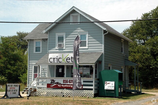
Property Record
511 Williamstown Rd, Sicklerville, NJ 08081


Property Detail
511 Williamstown Rd
36-02204-0000-00010
FACILITY NAME: STORE & APT
Commercialnec
Camden
C
New Jersey
B and X Area of moderate flood hazard, usually the area between the limits of the 100-year and 500-year floods.
10
2025
0.28 AC
2025
South Camden County
609202
Philadelphia
1,216 SF
Philadelphia-Camden-Wilmington, PA-NJ-DE-MD
NEARBY LISTINGS FOR SALE OR LEASE
DEMOGRAPHICS near 511 Williamstown Rd
1 mile
3 mile
5 mile
2025 Total Population
9,005
47,231
114,670
2030 Population
9,331
48,459
117,810
Pop Growth 2025-2030
+ 3.62%
+ 2.60%
+ 2.74%
Average Age
39
40
41
2025 Total Households
3,334
17,093
41,573
HH Growth 2025-2030
+ 3.72%
+ 2.68%
+ 2.84%
Median Household Inc
$78,676
$90,450
$97,667
Avg Household Size
2.70
2.70
2.70
2025 Avg HH Vehicles
2.00
2.00
2.00
Median Home Value
$239,032
$292,567
$301,826
Median Year Built
1982
1988
1986
Nearby Places
Map Layers
Map Styles
 Street
 Aerial
Transit
 Traffic
 Biking
Places
Listings with unknown addresses are not visible on the map
- Restaurants
- Banks
- Shops
- Fitness
- Groceries
PUBLIC TRANSPORTATION
COMMUTER RAIL
Atco (Atlantic City Line - NJ Transit Commuter Rail (NJ Transit))
Drive
Walk
Distance
Atco (Atlantic City Line - NJ Transit Commuter Rail (NJ Transit))
9 min
5.8 mi
AIRPORT
Philadelphia International
Drive
Walk
Distance
Philadelphia International
40 min
26.5 mi
Atlantic City International
Drive
Walk
Distance
Atlantic City International
60 min
33.5 mi
Freight Ports
Broadway Terminal - Pier 5
Drive
Walk
Distance
Broadway Terminal - Pier 5
25 min
18.0 mi
Nearby Properties
Address
Land Use
TOTAL SIZE
Lot Size
Zoning
Address
Land Use
TOTAL SIZE
Lot Size
Zoning
14.07 AC
Address
Land Use
TOTAL SIZE
Lot Size
Zoning
20.63 AC
C
Address
Land Use
TOTAL SIZE
Lot Size
Zoning
15.36 AC
Address
Land Use
TOTAL SIZE
Lot Size
Zoning
1,563 SF
32.90 AC
RL
Address
Land Use
TOTAL SIZE
Lot Size
Zoning
19.53 AC
R2
Address
Land Use
TOTAL SIZE
Lot Size
Zoning
13.69 AC
CC
Address
Land Use
TOTAL SIZE
Lot Size
Zoning
Address
Land Use
TOTAL SIZE
Lot Size
Zoning
15.60 AC
Address
Land Use
TOTAL SIZE
Lot Size
Zoning
12.66 AC
Address
Land Use
TOTAL SIZE
Lot Size
Zoning
1 SF
19.71 AC
CC
Address
Land Use
TOTAL SIZE
Lot Size
Zoning
9.76 AC
R2
Address
Land Use
TOTAL SIZE
Lot Size
Zoning
29.50 AC
FD10
Address
Land Use
TOTAL SIZE
Lot Size
Zoning
19.22 AC
Address
Land Use
TOTAL SIZE
Lot Size
Zoning
89,672 SF
30.01 AC
PR2
Address
Land Use
TOTAL SIZE
Lot Size
Zoning
7.69 AC
RG30
Address
Land Use
TOTAL SIZE
Lot Size
Zoning
7.08 AC
CM
Address
Land Use
TOTAL SIZE
Lot Size
Zoning
5.60 AC
Address
Land Use
TOTAL SIZE
Lot Size
Zoning
3.44 AC
RM
Address
Land Use
TOTAL SIZE
Lot Size
Zoning
13.03 AC
RL
Address
Land Use
TOTAL SIZE
Lot Size
Zoning
48,575 SF
17.52 AC
P
Address
Land Use
TOTAL SIZE
Lot Size
Zoning
12.13 AC
P
Address
Land Use
TOTAL SIZE
Lot Size
Zoning
2.80 AC
RG30
Address
Land Use
TOTAL SIZE
Lot Size
Zoning
6.51 AC
C
Address
Land Use
TOTAL SIZE
Lot Size
Zoning
Address
Land Use
TOTAL SIZE
Lot Size
Zoning
12.20 AC
CC
Address
Land Use
TOTAL SIZE
Lot Size
Zoning
0.92 AC
RGTC
Address
Land Use
TOTAL SIZE
Lot Size
Zoning
4.43 AC
C
Address
Land Use
TOTAL SIZE
Lot Size
Zoning
21,558 SF
19.04 AC
CM
Address
Land Use
TOTAL SIZE
Lot Size
Zoning
54,056 SF
17.26 AC
P
Address
Land Use
TOTAL SIZE
Lot Size
Zoning
4.06 AC
RG40
The World's #1 Commercial Real Estate Marketplace
Connect with us
© 2026 CoStar Group
The information above has been obtained from sources believed reliable. While we do not doubt its accuracy we have not verified it and make no guarantee, warranty or representation about it. It is your responsibility to independently confirm its accuracy and completeness. Any projections, opinions, assumptions, or estimates used are for example only and do not represent the current or future performance of the property. The value of this transaction to you depends on tax and other factors which should be evaluated by your tax, financial, and legal advisors. You and your advisors should conduct a careful, independent investigation of the property to determine to your satisfaction the suitability of the property for your needs.