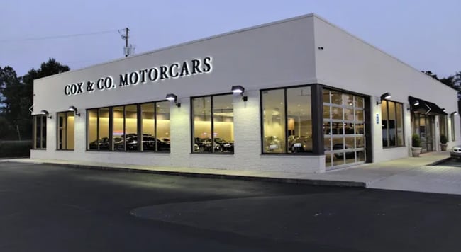
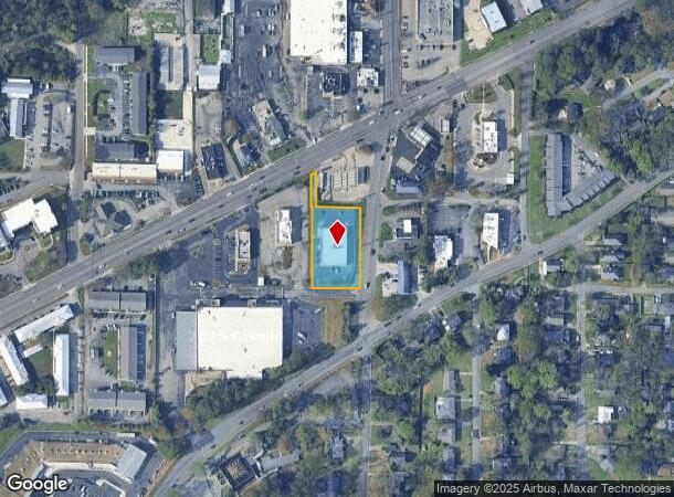
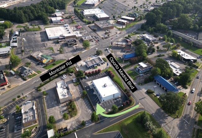
Property Record
5110 Oporto Ave S, Irondale, AL 35210
Current Lease Availabilities
NEARBY LISTINGS FOR SALE OR LEASE
Property Detail
5110 Oporto Ave S
Birmingham-Hoover, AL
Smith Res Of Bruno Eastw
23-00-26-3-007-003.005
LOT 2-B CORRECTED MAP SMITHS RESURVEY OF BRUNOS EASTWOOD PB 189 PG 97
Vehiclerentalsvehiclesales
Jefferson
X
Alabama
01073C0413H
2-b
2023
0.81 AC
2024
Midtown
012701
Birmingham
7,488 SF
DEMOGRAPHICS near 5110 Oporto Ave S
1 Mile
3 Mile
5 Mile
2024 Total Population
8,009
53,863
123,884
2029 Population
7,816
53,103
122,396
Pop Growth 2024-2029
(2.41%)
(1.41%)
(1.20%)
Average Age
40
39
39
2024 Total Households
3,663
22,495
52,561
HH Growth 2024-2029
(2.81%)
(1.56%)
(1.26%)
Median Household Inc
$68,587
$61,213
$59,205
Avg Household Size
2.00
2.30
2.20
2024 Avg HH Vehicles
2.00
2.00
2.00
Median Home Value
$252,822
$301,974
$318,070
Median Year Built
1970
1965
1967
Nearby Places
- Restaurants
- Banks
- Shops
- Fitness
- Groceries
PUBLIC TRANSPORTATION
COMMUTER RAIL
Birmingham (Crescent - Amtrak)
DRIVE
WALK
Distance
Birmingham (Crescent - Amtrak)
9 min
6.2 mi
AIRPORT
Birmingham-Shuttlesworth International
DRIVE
WALK
Distance
Birmingham-Shuttlesworth International
8 min
4.5 mi
Freight Ports
Port of Mobile
DRIVE
WALK
Distance
Port of Mobile
286 min
258.6 mi
Nearby Properties
Address
Land Use
TOTAL SIZE
Lot Size
Zoning
Address
Land Use
TOTAL SIZE
Lot Size
Zoning
298,966 SF
73 AC
M1
Address
Land Use
TOTAL SIZE
Lot Size
Zoning
166,863 SF
21 AC
CB2
Address
Land Use
TOTAL SIZE
Lot Size
Zoning
80,288 SF
2.91 AC
CB2
Address
Land Use
TOTAL SIZE
Lot Size
Zoning
155,160 SF
14.20 AC
B6
Address
Land Use
TOTAL SIZE
Lot Size
Zoning
423,995 SF
25 AC
R3
Address
Land Use
TOTAL SIZE
Lot Size
Zoning
144,135 SF
31.95 AC
CR5
Address
Land Use
TOTAL SIZE
Lot Size
Zoning
Address
Land Use
TOTAL SIZE
Lot Size
Zoning
297,391 SF
27.10 AC
CR5
Address
Land Use
TOTAL SIZE
Lot Size
Zoning
68,803 SF
3.93 AC
CP
Address
Land Use
TOTAL SIZE
Lot Size
Zoning
129,702 SF
8.20 AC
C-1
Address
Land Use
TOTAL SIZE
Lot Size
Zoning
131,319 SF
13.28 AC
CB2
Address
Land Use
TOTAL SIZE
Lot Size
Zoning
235,552 SF
10.13 AC
R3
Address
Land Use
TOTAL SIZE
Lot Size
Zoning
57,938 SF
6.85 AC
CP
Address
Land Use
TOTAL SIZE
Lot Size
Zoning
83,931 SF
5.90 AC
O&I
Address
Land Use
TOTAL SIZE
Lot Size
Zoning
456,619 SF
27.30 AC
M2
Address
Land Use
TOTAL SIZE
Lot Size
Zoning
52,407 SF
25.71 AC
R2
Address
Land Use
TOTAL SIZE
Lot Size
Zoning
74,154 SF
4.20 AC
R-A
Address
Land Use
TOTAL SIZE
Lot Size
Zoning
83,776 SF
3.79 AC
B6
Address
Land Use
TOTAL SIZE
Lot Size
Zoning
22 AC
CB2
Address
Land Use
TOTAL SIZE
Lot Size
Zoning
127,131 SF
22.40 AC
QR7
Address
Land Use
TOTAL SIZE
Lot Size
Zoning
210,920 SF
22.41 AC
CB2
Address
Land Use
TOTAL SIZE
Lot Size
Zoning
145,949 SF
10.01 AC
QR6
Address
Land Use
TOTAL SIZE
Lot Size
Zoning
102,748 SF
8.50 AC
CB2
Address
Land Use
TOTAL SIZE
Lot Size
Zoning
8.10 AC
QR6
Address
Land Use
TOTAL SIZE
Lot Size
Zoning
223,365 SF
15 AC
I1
Address
Land Use
TOTAL SIZE
Lot Size
Zoning
108,813 SF
156 AC
M-1
Address
Land Use
TOTAL SIZE
Lot Size
Zoning
95,702 SF
20.74 AC
R-B
Address
Land Use
TOTAL SIZE
Lot Size
Zoning
29,095 SF
2.64 AC
B2
Address
Land Use
TOTAL SIZE
Lot Size
Zoning
150,750 SF
12.60 AC
CR5
Address
Land Use
TOTAL SIZE
Lot Size
Zoning
301,531 SF
41 AC
B5
The World's #1 Commercial Real Estate Marketplace
Connect with us
© 2025 CoStar Group
The information above has been obtained from sources believed reliable. While we do not doubt its accuracy we have not verified it and make no guarantee, warranty or representation about it. It is your responsibility to independently confirm its accuracy and completeness. Any projections, opinions, assumptions, or estimates used are for example only and do not represent the current or future performance of the property. The value of this transaction to you depends on tax and other factors which should be evaluated by your tax, financial, and legal advisors. You and your advisors should conduct a careful, independent investigation of the property to determine to your satisfaction the suitability of the property for your needs.