Property Record
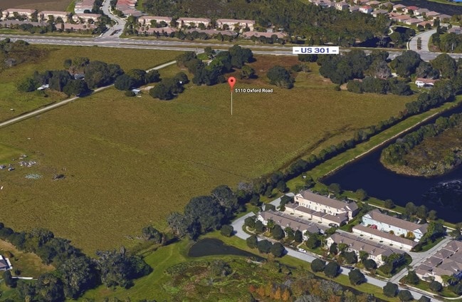
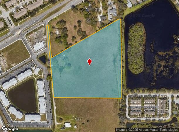
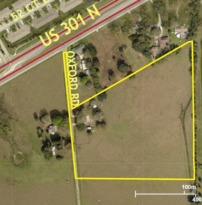
5110 Oxford Rd, Parrish, FL 34219
NEARBY LISTINGS FOR SALE OR LEASE
Property Detail
5110 Oxford Rd
4722-0000-5
Acreage
Vacantlandnec
BEG SW COR OF SE 1/4, GO E ALG S LN OF SEC 31 A DIST OF 1285.5 FT, NLY 573 FT FOR A POB; NLY ALG LAST DESC LN EXTD 938.8 FT; SWLY 974.45 FT ALG A LN MAKING AN I/A OF 59 DEG 21
X
Manatee
12081C0187F
Florida
2023
12.50 AC
2025
Manatee
001913
Tampa/St Petersburg
200 SF
North Port-Bradenton-Sarasota, FL
DEMOGRAPHICS near 5110 Oxford Rd
1 Mile
3 Mile
5 Mile
2024 Total Population
8,376
29,023
73,028
2029 Population
9,794
34,120
85,788
Pop Growth 2024-2029
+ 16.93%
+ 17.56%
+ 17.47%
Average Age
45
45
46
2024 Total Households
3,203
11,073
28,613
HH Growth 2024-2029
+ 15.99%
+ 16.64%
+ 16.58%
Median Household Inc
$97,948
$94,048
$88,686
Avg Household Size
2.50
2.50
2.50
2024 Avg HH Vehicles
2.00
2.00
2.00
Median Home Value
$287,537
$324,362
$331,113
Median Year Built
2007
2007
2006
Nearby Places
Map Layers
Map Styles
 Street
 Aerial
- Restaurants
- Banks
- Shops
- Fitness
- Groceries
PUBLIC TRANSPORTATION
AIRPORT
Sarasota/Bradenton International
DRIVE
WALK
Distance
Sarasota/Bradenton International
34 min
18.7 mi
St Pete-Clearwater International
DRIVE
WALK
Distance
St Pete-Clearwater International
60 min
42.0 mi
Tampa International
DRIVE
WALK
Distance
Tampa International
66 min
44.7 mi
Freight Ports
Port Manatee
DRIVE
WALK
Distance
Port Manatee
23 min
13.2 mi
SALE & LEASE HISTORY
LISTING DATE
SALE/LEASE

Mar 17, 2017
For Sale
Nearby Properties
Address
Land Use
TOTAL SIZE
Lot Size
Zoning
Address
Land Use
TOTAL SIZE
Lot Size
Zoning
137.34 AC
Address
Land Use
TOTAL SIZE
Lot Size
Zoning
313,422 SF
47.93 AC
PD-C
Address
Land Use
TOTAL SIZE
Lot Size
Zoning
47.43 AC
Address
Land Use
TOTAL SIZE
Lot Size
Zoning
64,800 SF
8.19 AC
Address
Land Use
TOTAL SIZE
Lot Size
Zoning
66,063 SF
9.24 AC
PD-C
Address
Land Use
TOTAL SIZE
Lot Size
Zoning
158.58 AC
Address
Land Use
TOTAL SIZE
Lot Size
Zoning
43,464 SF
14.47 AC
VIL VILLAG
Address
Land Use
TOTAL SIZE
Lot Size
Zoning
190.90 AC
PD-R
Address
Land Use
TOTAL SIZE
Lot Size
Zoning
43.81 AC
Address
Land Use
TOTAL SIZE
Lot Size
Zoning
50,580 SF
5.97 AC
Address
Land Use
TOTAL SIZE
Lot Size
Zoning
61,721 SF
5.50 AC
PD-C
Address
Land Use
TOTAL SIZE
Lot Size
Zoning
28,413 SF
5.40 AC
RSMH-6
Address
Land Use
TOTAL SIZE
Lot Size
Zoning
1,596 SF
106.35 AC
PD-R
Address
Land Use
TOTAL SIZE
Lot Size
Zoning
53,851 SF
6.32 AC
Address
Land Use
TOTAL SIZE
Lot Size
Zoning
30,101 SF
13.44 AC
PD-C
Address
Land Use
TOTAL SIZE
Lot Size
Zoning
41,168 SF
3.21 AC
PD-C
Address
Land Use
TOTAL SIZE
Lot Size
Zoning
22,855 SF
23.30 AC
PD-R
Address
Land Use
TOTAL SIZE
Lot Size
Zoning
76.98 AC
Address
Land Use
TOTAL SIZE
Lot Size
Zoning
23,742 SF
5.21 AC
A-1 SUBURB
Address
Land Use
TOTAL SIZE
Lot Size
Zoning
36,700 SF
17 AC
A-1 SUBURB
Address
Land Use
TOTAL SIZE
Lot Size
Zoning
44,874 SF
394.53 AC
PD-PI
Address
Land Use
TOTAL SIZE
Lot Size
Zoning
109.06 AC
Address
Land Use
TOTAL SIZE
Lot Size
Zoning
98.57 AC
A GENERAL
Address
Land Use
TOTAL SIZE
Lot Size
Zoning
25,912 SF
6.66 AC
PD-C
Address
Land Use
TOTAL SIZE
Lot Size
Zoning
4.07 AC
Address
Land Use
TOTAL SIZE
Lot Size
Zoning
34,830 SF
2.95 AC
GC GENERA
Address
Land Use
TOTAL SIZE
Lot Size
Zoning
19,000 SF
1.29 AC
GC GENERA
Address
Land Use
TOTAL SIZE
Lot Size
Zoning
53,448 SF
3 AC
PD-C
Address
Land Use
TOTAL SIZE
Lot Size
Zoning
25,842 SF
3.92 AC
Address
Land Use
TOTAL SIZE
Lot Size
Zoning
12,574 SF
5.91 AC
RSF-1
The World's #1 Commercial Real Estate Marketplace
Connect with us
© 2026 CoStar Group
The information above has been obtained from sources believed reliable. While we do not doubt its accuracy we have not verified it and make no guarantee, warranty or representation about it. It is your responsibility to independently confirm its accuracy and completeness. Any projections, opinions, assumptions, or estimates used are for example only and do not represent the current or future performance of the property. The value of this transaction to you depends on tax and other factors which should be evaluated by your tax, financial, and legal advisors. You and your advisors should conduct a careful, independent investigation of the property to determine to your satisfaction the suitability of the property for your needs.