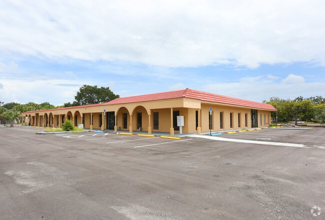
Property Record
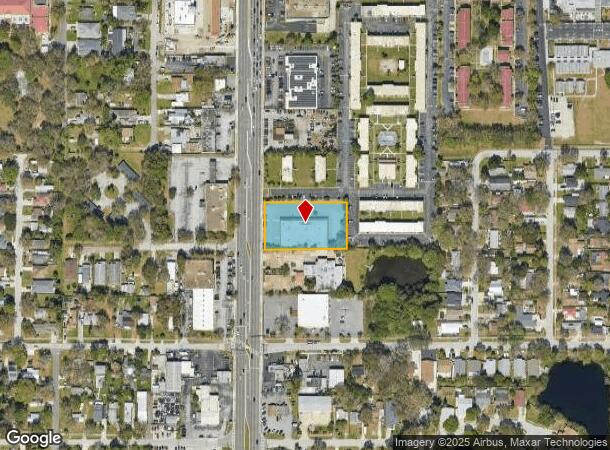
5111 66Th St N, Saint Petersburg, FL 33709

NEARBY LISTINGS FOR SALE OR LEASE
Property Detail
5111 66Th St N
Tampa-St. Petersburg-Clearwater, FL
Pinellas Farms
05-31-16-70002-200-0900
PINELLAS FARMS NW 1/4, SEC 05-31-16 SW 1/4 OF N 1/2 OF FARM 9 LESS 66TH ST R/W (PER OR 1999/420)
Nightclub
Pinellas
X
Florida
12103C0203J
9
2024
1.06 AC
2025
South Pinellas
024804
Tampa/St Petersburg
15,360 SF
DEMOGRAPHICS near 5111 66Th St N
1 Mile
3 Mile
5 Mile
2024 Total Population
15,762
108,401
266,155
2029 Population
15,771
108,305
267,267
Pop Growth 2024-2029
+ 0.06%
(0.09%)
+ 0.42%
Average Age
44
44
46
2024 Total Households
6,428
46,366
121,306
HH Growth 2024-2029
(0.22%)
(0.28%)
+ 0.40%
Median Household Inc
$50,215
$56,656
$59,716
Avg Household Size
2.30
2.20
2.10
2024 Avg HH Vehicles
2.00
2.00
2.00
Median Home Value
$202,560
$234,086
$250,624
Median Year Built
1970
1969
1970
Nearby Places
Map Layers
Map Styles
 Street
 Aerial
- Restaurants
- Banks
- Shops
- Fitness
- Groceries
PUBLIC TRANSPORTATION
AIRPORT
St Pete-Clearwater International
DRIVE
WALK
Distance
St Pete-Clearwater International
23 min
10.2 mi
Tampa International
DRIVE
WALK
Distance
Tampa International
33 min
19.9 mi
Sarasota/Bradenton International
DRIVE
WALK
Distance
Sarasota/Bradenton International
58 min
39.3 mi
SALE & LEASE HISTORY
LISTING DATE
SALE/LEASE

Aug 31, 2021
For Lease
Nearby Properties
Address
Land Use
TOTAL SIZE
Lot Size
Zoning
Address
Land Use
TOTAL SIZE
Lot Size
Zoning
459,848 SF
19.74 AC
R6
Address
Land Use
TOTAL SIZE
Lot Size
Zoning
738,882 SF
43.34 AC
Address
Land Use
TOTAL SIZE
Lot Size
Zoning
404,899 SF
35.35 AC
Address
Land Use
TOTAL SIZE
Lot Size
Zoning
396,428 SF
19.76 AC
Address
Land Use
TOTAL SIZE
Lot Size
Zoning
206,685 SF
16.75 AC
RPD5
Address
Land Use
TOTAL SIZE
Lot Size
Zoning
267,649 SF
17.86 AC
Address
Land Use
TOTAL SIZE
Lot Size
Zoning
263,050 SF
34.20 AC
Address
Land Use
TOTAL SIZE
Lot Size
Zoning
142,529 SF
46.62 AC
Address
Land Use
TOTAL SIZE
Lot Size
Zoning
186,094 SF
11.96 AC
Address
Land Use
TOTAL SIZE
Lot Size
Zoning
127,237 SF
10.53 AC
Address
Land Use
TOTAL SIZE
Lot Size
Zoning
150,235 SF
17.90 AC
Address
Land Use
TOTAL SIZE
Lot Size
Zoning
195,863 SF
18.57 AC
Address
Land Use
TOTAL SIZE
Lot Size
Zoning
360,137 SF
37.64 AC
AE
Address
Land Use
TOTAL SIZE
Lot Size
Zoning
156,994 SF
29.11 AC
Address
Land Use
TOTAL SIZE
Lot Size
Zoning
172,600 SF
20.57 AC
Address
Land Use
TOTAL SIZE
Lot Size
Zoning
172,768 SF
15.05 AC
RPD20
Address
Land Use
TOTAL SIZE
Lot Size
Zoning
113,365 SF
13.32 AC
Address
Land Use
TOTAL SIZE
Lot Size
Zoning
116,358 SF
12.74 AC
Address
Land Use
TOTAL SIZE
Lot Size
Zoning
248,572 SF
15.22 AC
PSP
Address
Land Use
TOTAL SIZE
Lot Size
Zoning
48,862 SF
3.72 AC
Address
Land Use
TOTAL SIZE
Lot Size
Zoning
220,805 SF
5.93 AC
Address
Land Use
TOTAL SIZE
Lot Size
Zoning
145,047 SF
12.03 AC
Address
Land Use
TOTAL SIZE
Lot Size
Zoning
154,986 SF
11.08 AC
Address
Land Use
TOTAL SIZE
Lot Size
Zoning
46,749 SF
5.80 AC
Address
Land Use
TOTAL SIZE
Lot Size
Zoning
49,898 SF
77.25 AC
Address
Land Use
TOTAL SIZE
Lot Size
Zoning
89,316 SF
9.24 AC
Address
Land Use
TOTAL SIZE
Lot Size
Zoning
119,580 SF
4.18 AC
Address
Land Use
TOTAL SIZE
Lot Size
Zoning
221,615 SF
16.33 AC
Address
Land Use
TOTAL SIZE
Lot Size
Zoning
117,837 SF
11.92 AC
Address
Land Use
TOTAL SIZE
Lot Size
Zoning
137,240 SF
11.38 AC
RPD125
The World's #1 Commercial Real Estate Marketplace
Connect with us
© 2025 CoStar Group
The information above has been obtained from sources believed reliable. While we do not doubt its accuracy we have not verified it and make no guarantee, warranty or representation about it. It is your responsibility to independently confirm its accuracy and completeness. Any projections, opinions, assumptions, or estimates used are for example only and do not represent the current or future performance of the property. The value of this transaction to you depends on tax and other factors which should be evaluated by your tax, financial, and legal advisors. You and your advisors should conduct a careful, independent investigation of the property to determine to your satisfaction the suitability of the property for your needs.