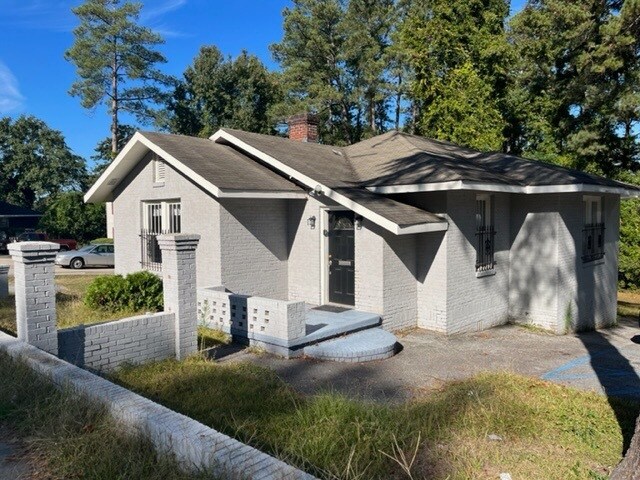
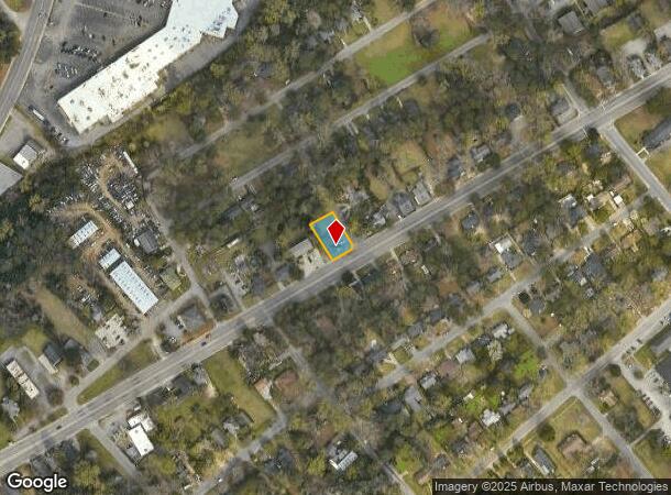
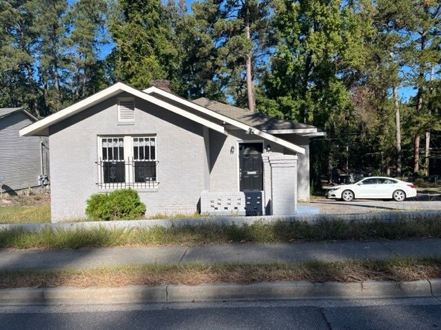
Property Record
5111 N Main St, Columbia, SC 29203
NEARBY LISTINGS FOR SALE OR LEASE
Property Detail
5111 N Main St
11701-08-13
College Place & Arden Heights
Commercialnec
PARCEL A 65.2X123.5X75.3X112.9X14.1 #SU COLLEGE PLACE #PR W/S Y-3997 RB2157-565
X
Richland
45079C0242L
South Carolina
2025
0.22 AC
2024
North Columbia
010600
Columbia
1,374 SF
Columbia, SC
DEMOGRAPHICS near 5111 N Main St
1 Mile
3 Mile
5 Mile
2024 Total Population
9,127
52,403
157,176
2029 Population
9,358
53,647
160,722
Pop Growth 2024-2029
+ 2.53%
+ 2.37%
+ 2.26%
Average Age
37
39
37
2024 Total Households
4,005
22,615
67,198
HH Growth 2024-2029
+ 2.65%
+ 2.44%
+ 2.43%
Median Household Inc
$24,352
$37,271
$43,607
Avg Household Size
2.20
2.10
2.10
2024 Avg HH Vehicles
1.00
1.00
1.00
Median Home Value
$102,949
$142,269
$191,212
Median Year Built
1967
1964
1969
Nearby Places
Map Layers
Map Styles
 Street
 Aerial
- Restaurants
- Banks
- Shops
- Fitness
- Groceries
PUBLIC TRANSPORTATION
COMMUTER RAIL
DRIVE
WALK
Distance
11 min
4.9 mi
AIRPORT
Columbia Metro
DRIVE
WALK
Distance
Columbia Metro
29 min
14.4 mi
SALE & LEASE HISTORY
LISTING DATE
SALE/LEASE

Nov 04, 2022
For Lease
Nearby Properties
Address
Land Use
TOTAL SIZE
Lot Size
Zoning
Address
Land Use
TOTAL SIZE
Lot Size
Zoning
501,365 SF
13.28 AC
O-I
Address
Land Use
TOTAL SIZE
Lot Size
Zoning
20,434 SF
17.20 AC
C-1
Address
Land Use
TOTAL SIZE
Lot Size
Zoning
85,065 SF
2.43 AC
C-1
Address
Land Use
TOTAL SIZE
Lot Size
Zoning
319,842 SF
0.78 AC
DAC
Address
Land Use
TOTAL SIZE
Lot Size
Zoning
100 SF
156.42 AC
RSF-2
Address
Land Use
TOTAL SIZE
Lot Size
Zoning
100 SF
19.24 AC
C-1
Address
Land Use
TOTAL SIZE
Lot Size
Zoning
14,360 SF
4.61 AC
C-1
Address
Land Use
TOTAL SIZE
Lot Size
Zoning
100 SF
15.68 AC
RG-2
Address
Land Use
TOTAL SIZE
Lot Size
Zoning
2,456 SF
5 AC
C-1
Address
Land Use
TOTAL SIZE
Lot Size
Zoning
96,189 SF
2.22 AC
C-1
Address
Land Use
TOTAL SIZE
Lot Size
Zoning
23,379 SF
3.76 AC
M-1
Address
Land Use
TOTAL SIZE
Lot Size
Zoning
115,734 SF
0.98 AC
C-1
Address
Land Use
TOTAL SIZE
Lot Size
Zoning
55.91 AC
M-1
Address
Land Use
TOTAL SIZE
Lot Size
Zoning
277,459 SF
9.74 AC
C-1
Address
Land Use
TOTAL SIZE
Lot Size
Zoning
65,058 SF
3.54 AC
C-1
Address
Land Use
TOTAL SIZE
Lot Size
Zoning
34,393 SF
2.96 AC
M-1
Address
Land Use
TOTAL SIZE
Lot Size
Zoning
67,200 SF
1.72 AC
C-1
Address
Land Use
TOTAL SIZE
Lot Size
Zoning
90,430 SF
0.42 AC
C-1
Address
Land Use
TOTAL SIZE
Lot Size
Zoning
23,916 SF
4.43 AC
RG-2
Address
Land Use
TOTAL SIZE
Lot Size
Zoning
124,272 SF
7.06 AC
RM-HD
Address
Land Use
TOTAL SIZE
Lot Size
Zoning
100 SF
44.73 AC
C-1
Address
Land Use
TOTAL SIZE
Lot Size
Zoning
63,842 SF
3.52 AC
C-3
Address
Land Use
TOTAL SIZE
Lot Size
Zoning
4,986 SF
5.74 AC
PUD-C
Address
Land Use
TOTAL SIZE
Lot Size
Zoning
95,254 SF
6.99 AC
RG-2
Address
Land Use
TOTAL SIZE
Lot Size
Zoning
138,738 SF
2.85 AC
O-I
Address
Land Use
TOTAL SIZE
Lot Size
Zoning
103,405 SF
0.38 AC
C-3
Address
Land Use
TOTAL SIZE
Lot Size
Zoning
82,692 SF
5.87 AC
C-3
Address
Land Use
TOTAL SIZE
Lot Size
Zoning
3.28 AC
C-4
Address
Land Use
TOTAL SIZE
Lot Size
Zoning
134,400 SF
5.85 AC
RG-2
Address
Land Use
TOTAL SIZE
Lot Size
Zoning
100 SF
4.44 AC
C-3
The World's #1 Commercial Real Estate Marketplace
Connect with us
© 2025 CoStar Group
The information above has been obtained from sources believed reliable. While we do not doubt its accuracy we have not verified it and make no guarantee, warranty or representation about it. It is your responsibility to independently confirm its accuracy and completeness. Any projections, opinions, assumptions, or estimates used are for example only and do not represent the current or future performance of the property. The value of this transaction to you depends on tax and other factors which should be evaluated by your tax, financial, and legal advisors. You and your advisors should conduct a careful, independent investigation of the property to determine to your satisfaction the suitability of the property for your needs.