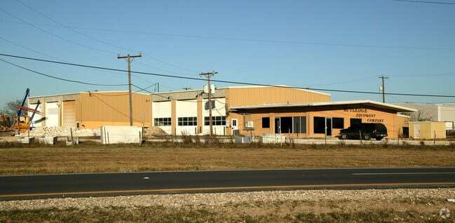
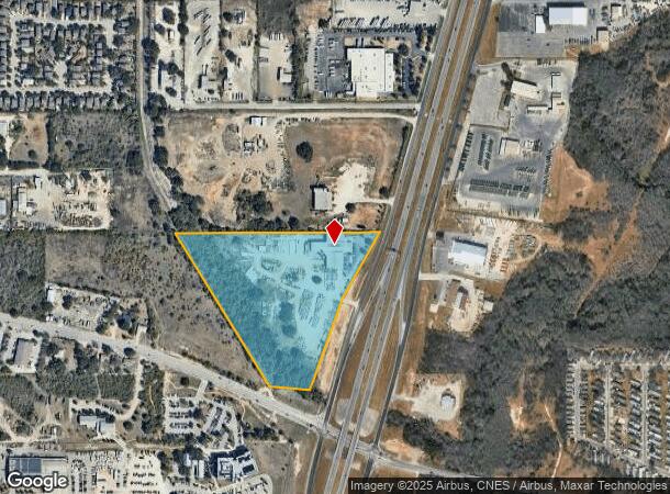
Property Record
5111 Se Loop 410, San Antonio, TX 78222
NEARBY LISTINGS FOR SALE OR LEASE
Property Detail
5111 Se Loop 410
San Antonio-New Braunfels, TX
Conv A/S Code
10852-000-0120
NCB 10852 BLK LOT 11, 12, P-8A & PT OF ARB F OR 6B 2012 MERGE PER CR #25808 - COMML LINK PROJECT.
Officebuilding
Bexar
AE
Texas
48029C0420G
12
2024
16.41 AC
2025
South
131300
San Antonio
29,520 SF
DEMOGRAPHICS near 5111 Se Loop 410
1 Mile
3 Mile
5 Mile
2024 Total Population
6,547
59,454
145,215
2029 Population
7,045
63,570
155,886
Pop Growth 2024-2029
+ 7.61%
+ 6.92%
+ 7.35%
Average Age
35
37
37
2024 Total Households
2,206
20,477
50,468
HH Growth 2024-2029
+ 7.71%
+ 7.06%
+ 7.44%
Median Household Inc
$60,555
$49,932
$43,823
Avg Household Size
2.90
2.80
2.80
2024 Avg HH Vehicles
2.00
2.00
2.00
Median Home Value
$150,315
$159,578
$149,106
Median Year Built
1992
1977
1973
Nearby Places
Map Layers
Map Styles
 Street
 Aerial
- Restaurants
- Banks
- Shops
- Fitness
- Groceries
PUBLIC TRANSPORTATION
COMMUTER RAIL
San Antonio Amtrak Station (Sunset Limited - Amtrak, Texas Eagle - Amtrak)
DRIVE
WALK
Distance
San Antonio Amtrak Station (Sunset Limited - Amtrak, Texas Eagle - Amtrak)
13 min
7.9 mi
AIRPORT
San Antonio International
DRIVE
WALK
Distance
San Antonio International
22 min
16.8 mi
Freight Ports
Calhoun Port
DRIVE
WALK
Distance
Calhoun Port
170 min
141.3 mi
Nearby Properties
Address
Land Use
TOTAL SIZE
Lot Size
Zoning
Address
Land Use
TOTAL SIZE
Lot Size
Zoning
122,130 SF
541.40 AC
Address
Land Use
TOTAL SIZE
Lot Size
Zoning
348,974 SF
20.98 AC
Address
Land Use
TOTAL SIZE
Lot Size
Zoning
397,806 SF
15.08 AC
Address
Land Use
TOTAL SIZE
Lot Size
Zoning
359,459 SF
15.81 AC
Address
Land Use
TOTAL SIZE
Lot Size
Zoning
380,949 SF
146.39 AC
Address
Land Use
TOTAL SIZE
Lot Size
Zoning
380,949 SF
135.47 AC
Address
Land Use
TOTAL SIZE
Lot Size
Zoning
35.76 AC
Address
Land Use
TOTAL SIZE
Lot Size
Zoning
273,370 SF
11.93 AC
Address
Land Use
TOTAL SIZE
Lot Size
Zoning
245,745 SF
11.99 AC
Address
Land Use
TOTAL SIZE
Lot Size
Zoning
33.77 AC
Address
Land Use
TOTAL SIZE
Lot Size
Zoning
193,243 SF
9.03 AC
Address
Land Use
TOTAL SIZE
Lot Size
Zoning
4,920 SF
860.60 AC
Address
Land Use
TOTAL SIZE
Lot Size
Zoning
101,517 SF
13.04 AC
Address
Land Use
TOTAL SIZE
Lot Size
Zoning
95,486 SF
12.54 AC
Address
Land Use
TOTAL SIZE
Lot Size
Zoning
332,148 SF
17.75 AC
Address
Land Use
TOTAL SIZE
Lot Size
Zoning
186,995 SF
14.18 AC
Address
Land Use
TOTAL SIZE
Lot Size
Zoning
1,859 SF
60.40 AC
Address
Land Use
TOTAL SIZE
Lot Size
Zoning
44,800 SF
61.44 AC
Address
Land Use
TOTAL SIZE
Lot Size
Zoning
217,483 SF
21.94 AC
Address
Land Use
TOTAL SIZE
Lot Size
Zoning
167,114 SF
2.71 AC
Address
Land Use
TOTAL SIZE
Lot Size
Zoning
204,166 SF
23.69 AC
Address
Land Use
TOTAL SIZE
Lot Size
Zoning
137,628 SF
15.38 AC
Address
Land Use
TOTAL SIZE
Lot Size
Zoning
177,692 SF
9.16 AC
Address
Land Use
TOTAL SIZE
Lot Size
Zoning
259,779 SF
14.85 AC
Address
Land Use
TOTAL SIZE
Lot Size
Zoning
163,255 SF
10.43 AC
Address
Land Use
TOTAL SIZE
Lot Size
Zoning
35,612 SF
7.15 AC
Address
Land Use
TOTAL SIZE
Lot Size
Zoning
188,176 SF
12.51 AC
Address
Land Use
TOTAL SIZE
Lot Size
Zoning
128,485 SF
17.59 AC
Address
Land Use
TOTAL SIZE
Lot Size
Zoning
128,976 SF
15.01 AC
Address
Land Use
TOTAL SIZE
Lot Size
Zoning
171,734 SF
40.14 AC
The World's #1 Commercial Real Estate Marketplace
Connect with us
© 2025 CoStar Group
The information above has been obtained from sources believed reliable. While we do not doubt its accuracy we have not verified it and make no guarantee, warranty or representation about it. It is your responsibility to independently confirm its accuracy and completeness. Any projections, opinions, assumptions, or estimates used are for example only and do not represent the current or future performance of the property. The value of this transaction to you depends on tax and other factors which should be evaluated by your tax, financial, and legal advisors. You and your advisors should conduct a careful, independent investigation of the property to determine to your satisfaction the suitability of the property for your needs.