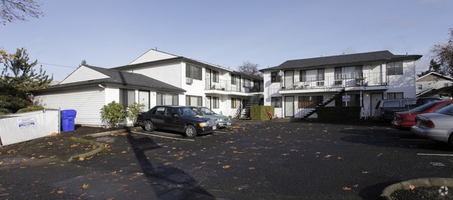
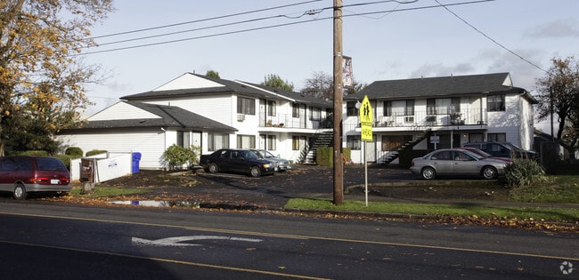
Property Record
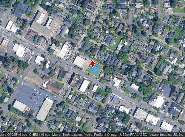
5113 N Lombard St, Portland, OR 97203

NEARBY LISTINGS FOR SALE OR LEASE
Property Detail
5113 N Lombard St
Portland-Vancouver-Hillsboro, OR-WA
University Pk
R292257
UNIVERSITY PK, BLOCK 100, LOT 16-18
Multifamilydwelling
Multnomah
ARE
Oregon
41067C0400E
16-18
2025
0.26 AC
2025
Portsmouth
004003
Portland
8,096 SF
DEMOGRAPHICS near 5113 N Lombard St
1 Mile
3 Mile
5 Mile
2024 Total Population
19,987
71,848
228,407
2029 Population
19,471
70,648
227,597
Pop Growth 2024-2029
(2.58%)
(1.67%)
(0.35%)
Average Age
35
38
40
2024 Total Households
6,682
29,318
107,458
HH Growth 2024-2029
(3.07%)
(1.86%)
(0.28%)
Median Household Inc
$76,477
$86,127
$85,784
Avg Household Size
2.50
2.30
2.00
2024 Avg HH Vehicles
2.00
2.00
1.00
Median Home Value
$464,628
$488,022
$639,622
Median Year Built
1957
1954
1971
Nearby Places
Map Layers
Map Styles
 Street
 Aerial
- Restaurants
- Banks
- Shops
- Fitness
- Groceries
PUBLIC TRANSPORTATION
COMMUTER RAIL
DRIVE
WALK
Distance
13 min
6.0 mi
DRIVE
WALK
Distance
16 min
6.6 mi
AIRPORT
Portland International
DRIVE
WALK
Distance
Portland International
22 min
9.3 mi
Freight Ports
Port of Portland
DRIVE
WALK
Distance
Port of Portland
13 min
6.7 mi
Nearby Properties
Address
Land Use
TOTAL SIZE
Lot Size
Zoning
Address
Land Use
TOTAL SIZE
Lot Size
Zoning
200,109 SF
70.44 AC
IH
Address
Land Use
TOTAL SIZE
Lot Size
Zoning
882,480 SF
80.73 AC
CI1
Address
Land Use
TOTAL SIZE
Lot Size
Zoning
437,419 SF
37.90 AC
IG2
Address
Land Use
TOTAL SIZE
Lot Size
Zoning
Address
Land Use
TOTAL SIZE
Lot Size
Zoning
Address
Land Use
TOTAL SIZE
Lot Size
Zoning
262,045 SF
17.10 AC
R5
Address
Land Use
TOTAL SIZE
Lot Size
Zoning
645,294 SF
5.64 AC
CO2D
Address
Land Use
TOTAL SIZE
Lot Size
Zoning
490,802 SF
56.17 AC
CGX
Address
Land Use
TOTAL SIZE
Lot Size
Zoning
335.31 AC
OS
Address
Land Use
TOTAL SIZE
Lot Size
Zoning
1,660,710 SF
110.33 AC
IG2
Address
Land Use
TOTAL SIZE
Lot Size
Zoning
191,506 SF
10.43 AC
IH
Address
Land Use
TOTAL SIZE
Lot Size
Zoning
537,280 SF
NULL
Address
Land Use
TOTAL SIZE
Lot Size
Zoning
85,000 SF
1.65 AC
CI2
Address
Land Use
TOTAL SIZE
Lot Size
Zoning
318,562 SF
33.59 AC
CI1
Address
Land Use
TOTAL SIZE
Lot Size
Zoning
97,000 SF
NULL
Address
Land Use
TOTAL SIZE
Lot Size
Zoning
Address
Land Use
TOTAL SIZE
Lot Size
Zoning
100 SF
82.93 AC
IH
Address
Land Use
TOTAL SIZE
Lot Size
Zoning
73,657 SF
1.90 AC
CI1
Address
Land Use
TOTAL SIZE
Lot Size
Zoning
8.01 AC
EG2
Address
Land Use
TOTAL SIZE
Lot Size
Zoning
112,578 SF
2.94 AC
CI2
Address
Land Use
TOTAL SIZE
Lot Size
Zoning
963,658 SF
64.43 AC
IH
Address
Land Use
TOTAL SIZE
Lot Size
Zoning
37,770 SF
6.90 AC
EG2
Address
Land Use
TOTAL SIZE
Lot Size
Zoning
Address
Land Use
TOTAL SIZE
Lot Size
Zoning
610,230 SF
26.65 AC
IH
Address
Land Use
TOTAL SIZE
Lot Size
Zoning
Address
Land Use
TOTAL SIZE
Lot Size
Zoning
Address
Land Use
TOTAL SIZE
Lot Size
Zoning
24.54 AC
IH
Address
Land Use
TOTAL SIZE
Lot Size
Zoning
909,769 SF
29.86 AC
IHI
Address
Land Use
TOTAL SIZE
Lot Size
Zoning
151,815 SF
2.10 AC
CM3
Address
Land Use
TOTAL SIZE
Lot Size
Zoning
229,981 SF
5.29 AC
EG2_EG2C
The World's #1 Commercial Real Estate Marketplace
Connect with us
© 2026 CoStar Group
The information above has been obtained from sources believed reliable. While we do not doubt its accuracy we have not verified it and make no guarantee, warranty or representation about it. It is your responsibility to independently confirm its accuracy and completeness. Any projections, opinions, assumptions, or estimates used are for example only and do not represent the current or future performance of the property. The value of this transaction to you depends on tax and other factors which should be evaluated by your tax, financial, and legal advisors. You and your advisors should conduct a careful, independent investigation of the property to determine to your satisfaction the suitability of the property for your needs.