Property Record
5115 Carpenter Rd, Ypsilanti, MI 48197
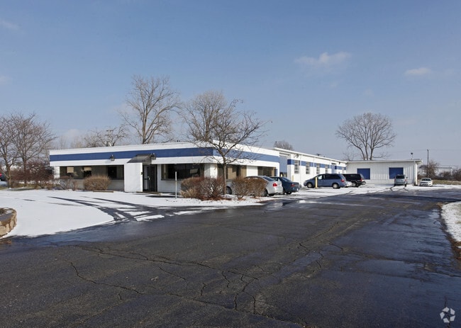

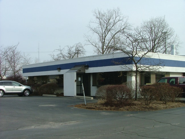
Property Detail
5115 Carpenter Rd
12-24-200-052
REWRITE PER WD L3211 P483 ****FROM 1224200009 01/25/91 PI 24-11J-2 ( 09-90 ) COM AT NW COR SEC 24, TH S 01-02-30 E 595.00 FT,
Distributionwarehouseregional
Washtenaw
BI
Michigan
B and X Area of moderate flood hazard, usually the area between the limits of the 100-year and 500-year floods.
2.37 AC
2025
Washtenaw E of 23
2025
Detroit
416000
Ann Arbor, MI
15,352 SF
NEARBY LISTINGS FOR SALE OR LEASE
DEMOGRAPHICS near 5115 Carpenter Rd
1 mile
3 mile
5 mile
2025 Total Population
5,827
42,191
137,439
2030 Population
5,768
42,271
140,859
Pop Growth 2025-2030
(1.01%)
+ 0.19%
+ 2.49%
Average Age
36
39
38
2025 Total Households
2,378
17,750
57,695
HH Growth 2025-2030
(0.84%)
+ 0.06%
+ 2.59%
Median Household Inc
$90,707
$72,568
$76,129
Avg Household Size
2.40
2.20
2.20
2025 Avg HH Vehicles
2.00
2.00
2.00
Median Home Value
$323,004
$309,666
$330,194
Median Year Built
1992
1978
1981
Nearby Places
Map Layers
Map Styles
 Street
 Aerial
Layers
 Traffic
 Biking
Places
Listings with unknown addresses are not visible on the map
- Restaurants
- Banks
- Shops
- Fitness
- Groceries
PUBLIC TRANSPORTATION
COMMUTER RAIL
Drive
Walk
Distance
15 min
7.3 mi
AIRPORT
Detroit Metro Wayne County
Drive
Walk
Distance
Detroit Metro Wayne County
32 min
22.4 mi
Freight Ports
Drive
Walk
Distance
70 min
52.9 mi
Nearby Properties
Address
Land Use
TOTAL SIZE
Lot Size
Zoning
Address
Land Use
TOTAL SIZE
Lot Size
Zoning
36,000 SF
27.61 AC
BI
Address
Land Use
TOTAL SIZE
Lot Size
Zoning
112,994 SF
45.12 AC
IH
Address
Land Use
TOTAL SIZE
Lot Size
Zoning
140,039 SF
Address
Land Use
TOTAL SIZE
Lot Size
Zoning
37,500 SF
25.94 AC
BI
Address
Land Use
TOTAL SIZE
Lot Size
Zoning
253,702 SF
30.23 AC
Address
Land Use
TOTAL SIZE
Lot Size
Zoning
17,672 SF
33.37 AC
BI
Address
Land Use
TOTAL SIZE
Lot Size
Zoning
32,040 SF
22.33 AC
BI
Address
Land Use
TOTAL SIZE
Lot Size
Zoning
27,603 SF
35.42 AC
BI
Address
Land Use
TOTAL SIZE
Lot Size
Zoning
111,435 SF
21.38 AC
R4B
Address
Land Use
TOTAL SIZE
Lot Size
Zoning
480 SF
23.64 AC
BI
Address
Land Use
TOTAL SIZE
Lot Size
Zoning
317,872 SF
11.79 AC
M1
Address
Land Use
TOTAL SIZE
Lot Size
Zoning
27,306 SF
16.08 AC
BI
Address
Land Use
TOTAL SIZE
Lot Size
Zoning
18,148 SF
21.62 AC
BI
Address
Land Use
TOTAL SIZE
Lot Size
Zoning
13,224 SF
24.30 AC
BI
Address
Land Use
TOTAL SIZE
Lot Size
Zoning
159,947 SF
14.19 AC
Address
Land Use
TOTAL SIZE
Lot Size
Zoning
132,937 SF
13.92 AC
R4A
Address
Land Use
TOTAL SIZE
Lot Size
Zoning
8.02 AC
R4B
Address
Land Use
TOTAL SIZE
Lot Size
Zoning
38,070 SF
21.15 AC
BI
Address
Land Use
TOTAL SIZE
Lot Size
Zoning
18,110 SF
14.80 AC
BI
Address
Land Use
TOTAL SIZE
Lot Size
Zoning
1,344 SF
18.17 AC
SPLIT
Address
Land Use
TOTAL SIZE
Lot Size
Zoning
136,968 SF
10.53 AC
R4A
Address
Land Use
TOTAL SIZE
Lot Size
Zoning
222,002 SF
26.04 AC
Address
Land Use
TOTAL SIZE
Lot Size
Zoning
159,208 SF
18.73 AC
R3
Address
Land Use
TOTAL SIZE
Lot Size
Zoning
64,989 SF
9.03 AC
R4A
Address
Land Use
TOTAL SIZE
Lot Size
Zoning
38,769 SF
14.85 AC
BI
Address
Land Use
TOTAL SIZE
Lot Size
Zoning
119,320 SF
6.13 AC
ME
Address
Land Use
TOTAL SIZE
Lot Size
Zoning
12,747 SF
22.86 AC
BA
Address
Land Use
TOTAL SIZE
Lot Size
Zoning
32,974 SF
29.96 AC
BA
Address
Land Use
TOTAL SIZE
Lot Size
Zoning
17,228 SF
8.40 AC
Address
Land Use
TOTAL SIZE
Lot Size
Zoning
40,389 SF
9.81 AC
BI
The World's #1 Commercial Real Estate Marketplace
Connect with us
© 2026 CoStar Group
The information above has been obtained from sources believed reliable. While we do not doubt its accuracy we have not verified it and make no guarantee, warranty or representation about it. It is your responsibility to independently confirm its accuracy and completeness. Any projections, opinions, assumptions, or estimates used are for example only and do not represent the current or future performance of the property. The value of this transaction to you depends on tax and other factors which should be evaluated by your tax, financial, and legal advisors. You and your advisors should conduct a careful, independent investigation of the property to determine to your satisfaction the suitability of the property for your needs.