Property Record
5115 Hartford St, Tampa, FL 33619
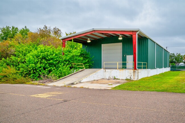
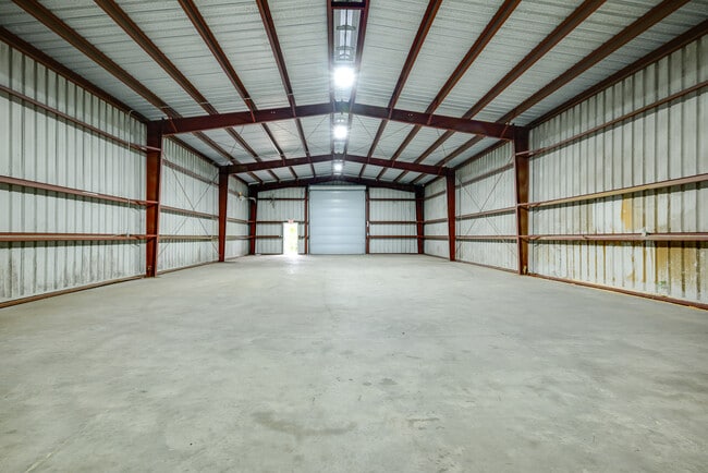

This Property Is For Sale
NEARBY LISTINGS FOR SALE OR LEASE
Property Detail
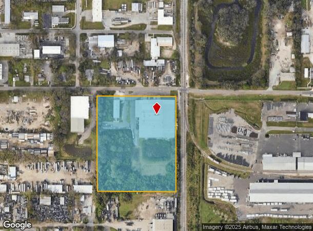
5115 Hartford St
Tampa-St. Petersburg-Clearwater, FL
South Tampa Subdivision
U-34-29-19-663-000001-62450.0
SOUTH TAMPA SUBDIVISION TRACT 11 IN SW 1/4 LESS R/W
Warehouse
Hillsborough
AE
Florida
12057C0367J
62450
2024
7.81 AC
2024
East Side
013602
Tampa/St Petersburg
75,020 SF
DEMOGRAPHICS near 5115 Hartford St
1 Mile
3 Mile
5 Mile
2024 Total Population
491
32,169
144,107
2029 Population
541
35,487
158,283
Pop Growth 2024-2029
+ 10.18%
+ 10.31%
+ 9.84%
Average Age
40
37
37
2024 Total Households
154
11,540
59,576
HH Growth 2024-2029
+ 10.39%
+ 10.69%
+ 10.37%
Median Household Inc
$50,455
$52,395
$61,855
Avg Household Size
3.00
2.70
2.30
2024 Avg HH Vehicles
2.00
2.00
2.00
Median Home Value
$188,461
$207,604
$261,131
Median Year Built
1980
1991
2001
Nearby Places
Map Layers
Map Styles
 Street
 Aerial
- Restaurants
- Banks
- Shops
- Fitness
- Groceries
PUBLIC TRANSPORTATION
COMMUTER RAIL
DRIVE
WALK
Distance
12 min
6.3 mi
AIRPORT
Tampa International
DRIVE
WALK
Distance
Tampa International
25 min
15.3 mi
St Pete-Clearwater International
DRIVE
WALK
Distance
St Pete-Clearwater International
36 min
23.8 mi
Freight Ports
Port of Tampa Bay
DRIVE
WALK
Distance
Port of Tampa Bay
10 min
4.6 mi
Nearby Properties
Address
Land Use
TOTAL SIZE
Lot Size
Zoning
Address
Land Use
TOTAL SIZE
Lot Size
Zoning
325,857 SF
16.32 AC
PD
Address
Land Use
TOTAL SIZE
Lot Size
Zoning
366,971 SF
33.26 AC
PD
Address
Land Use
TOTAL SIZE
Lot Size
Zoning
372,714 SF
150.13 AC
IH
Address
Land Use
TOTAL SIZE
Lot Size
Zoning
338,628 SF
14.60 AC
PD
Address
Land Use
TOTAL SIZE
Lot Size
Zoning
284,156 SF
19.32 AC
PD
Address
Land Use
TOTAL SIZE
Lot Size
Zoning
259,451 SF
13.73 AC
PD
Address
Land Use
TOTAL SIZE
Lot Size
Zoning
991,178 SF
99.01 AC
M
Address
Land Use
TOTAL SIZE
Lot Size
Zoning
476,371 SF
41.23 AC
PD
Address
Land Use
TOTAL SIZE
Lot Size
Zoning
232,492 SF
51.94 AC
AR
Address
Land Use
TOTAL SIZE
Lot Size
Zoning
384,604 SF
21.63 AC
M
Address
Land Use
TOTAL SIZE
Lot Size
Zoning
384,728 SF
20.14 AC
PD
Address
Land Use
TOTAL SIZE
Lot Size
Zoning
378,775 SF
16 AC
PD
Address
Land Use
TOTAL SIZE
Lot Size
Zoning
297,904 SF
20.16 AC
M
Address
Land Use
TOTAL SIZE
Lot Size
Zoning
5,920 SF
12.39 AC
M
Address
Land Use
TOTAL SIZE
Lot Size
Zoning
160,552 SF
11.22 AC
PD
Address
Land Use
TOTAL SIZE
Lot Size
Zoning
288,158 SF
49.11 AC
IH
Address
Land Use
TOTAL SIZE
Lot Size
Zoning
260,212 SF
17.96 AC
PD
Address
Land Use
TOTAL SIZE
Lot Size
Zoning
172,638 SF
120.94 AC
IG
Address
Land Use
TOTAL SIZE
Lot Size
Zoning
271,365 SF
19.30 AC
M
Address
Land Use
TOTAL SIZE
Lot Size
Zoning
178,744 SF
15.62 AC
IG
Address
Land Use
TOTAL SIZE
Lot Size
Zoning
302,062 SF
18.81 AC
IH
Address
Land Use
TOTAL SIZE
Lot Size
Zoning
5,341 SF
36.48 AC
IH
Address
Land Use
TOTAL SIZE
Lot Size
Zoning
279,608 SF
17.05 AC
PD
Address
Land Use
TOTAL SIZE
Lot Size
Zoning
127,700 SF
4.91 AC
PD
Address
Land Use
TOTAL SIZE
Lot Size
Zoning
186,345 SF
115.75 AC
M
Address
Land Use
TOTAL SIZE
Lot Size
Zoning
184,359 SF
17.06 AC
PD
Address
Land Use
TOTAL SIZE
Lot Size
Zoning
137,637 SF
13.69 AC
IH
Address
Land Use
TOTAL SIZE
Lot Size
Zoning
139,925 SF
13.92 AC
PD
Address
Land Use
TOTAL SIZE
Lot Size
Zoning
363,962 SF
19.53 AC
M
Address
Land Use
TOTAL SIZE
Lot Size
Zoning
131,278 SF
13.33 AC
PD
The World's #1 Commercial Real Estate Marketplace
Connect with us
© 2026 CoStar Group
The information above has been obtained from sources believed reliable. While we do not doubt its accuracy we have not verified it and make no guarantee, warranty or representation about it. It is your responsibility to independently confirm its accuracy and completeness. Any projections, opinions, assumptions, or estimates used are for example only and do not represent the current or future performance of the property. The value of this transaction to you depends on tax and other factors which should be evaluated by your tax, financial, and legal advisors. You and your advisors should conduct a careful, independent investigation of the property to determine to your satisfaction the suitability of the property for your needs.