Property Record
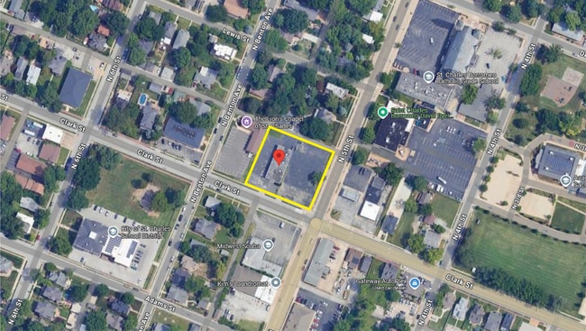
512 Clark St, Saint Charles, MO 63301
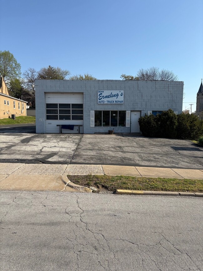

This Property Is For Sale
Property Detail
512 Clark St
6-009A-B152-00-0005.0000000
PT CITY BLK 152
Commercialnec
ST. CHARLES
AA4
Missouri
B and X Area of moderate flood hazard, usually the area between the limits of the 100-year and 500-year floods.
5
2024
0.78 AC
2025
St Charles Region
310400
St. Louis
4,545 SF
St. Louis, MO-IL
NEARBY LISTINGS FOR SALE OR LEASE
DEMOGRAPHICS near 512 Clark St
1 mile
3 mile
5 mile
2025 Total Population
10,520
55,978
117,407
2030 Population
10,909
57,933
120,776
Pop Growth 2025-2030
+ 3.70%
+ 3.49%
+ 2.87%
Average Age
39
41
42
2025 Total Households
4,021
24,012
49,921
HH Growth 2025-2030
+ 3.95%
+ 3.65%
+ 3.01%
Median Household Inc
$70,314
$77,393
$84,275
Avg Household Size
2.10
2.20
2.20
2025 Avg HH Vehicles
2.00
2.00
2.00
Median Home Value
$247,997
$271,140
$278,684
Median Year Built
1950
1976
1981
Nearby Places
Map Layers
Map Styles
 Street
 Aerial
Layers
 Traffic
 Biking
Places
Listings with unknown addresses are not visible on the map
- Restaurants
- Banks
- Shops
- Fitness
- Groceries
PUBLIC TRANSPORTATION
COMMUTER RAIL
Lambert Airport East Terminal (Lambert Airport Shiloh-Scott - St. Louis MetroLink (MetroLink))
Drive
Walk
Distance
Lambert Airport East Terminal (Lambert Airport Shiloh-Scott - St. Louis MetroLink (MetroLink))
17 min
10.0 mi
AIRPORT
St Louis Lambert International
Drive
Walk
Distance
St Louis Lambert International
18 min
10.7 mi
Scott AFB/Midamerica St Louis
Drive
Walk
Distance
Scott AFB/Midamerica St Louis
68 min
46.5 mi
Nearby Properties
Address
Land Use
TOTAL SIZE
Lot Size
Zoning
Address
Land Use
TOTAL SIZE
Lot Size
Zoning
2,918,475 SF
30.32 AC
AC1
Address
Land Use
TOTAL SIZE
Lot Size
Zoning
553,382 SF
109.67 AC
FPNU
Address
Land Use
TOTAL SIZE
Lot Size
Zoning
440,000 SF
2.11 AC
Address
Land Use
TOTAL SIZE
Lot Size
Zoning
256,719 SF
27 AC
104PDM
Address
Land Use
TOTAL SIZE
Lot Size
Zoning
140,801 SF
6.35 AC
Address
Land Use
TOTAL SIZE
Lot Size
Zoning
833,525 SF
25.53 AC
R1
Address
Land Use
TOTAL SIZE
Lot Size
Zoning
581,756 SF
47.18 AC
AC2
Address
Land Use
TOTAL SIZE
Lot Size
Zoning
43,890 SF
28.96 AC
Address
Land Use
TOTAL SIZE
Lot Size
Zoning
564,552 SF
42.07 AC
10M-1
Address
Land Use
TOTAL SIZE
Lot Size
Zoning
542,500 SF
39.91 AC
FPNU
Address
Land Use
TOTAL SIZE
Lot Size
Zoning
332,323 SF
22.40 AC
104PDM
Address
Land Use
TOTAL SIZE
Lot Size
Zoning
662,199 SF
26.58 AC
10M-1
Address
Land Use
TOTAL SIZE
Lot Size
Zoning
488,536 SF
23.53 AC
AF0
Address
Land Use
TOTAL SIZE
Lot Size
Zoning
281,074 SF
8.79 AC
Address
Land Use
TOTAL SIZE
Lot Size
Zoning
312,516 SF
2.18 AC
Address
Land Use
TOTAL SIZE
Lot Size
Zoning
448,590 SF
24.75 AC
M3
Address
Land Use
TOTAL SIZE
Lot Size
Zoning
120,050 SF
1.51 AC
Address
Land Use
TOTAL SIZE
Lot Size
Zoning
158,499 SF
27.01 AC
FPM3
Address
Land Use
TOTAL SIZE
Lot Size
Zoning
395,327 SF
34.69 AC
Address
Land Use
TOTAL SIZE
Lot Size
Zoning
87,027 SF
16.04 AC
AC4
Address
Land Use
TOTAL SIZE
Lot Size
Zoning
83.11 AC
AC9
Address
Land Use
TOTAL SIZE
Lot Size
Zoning
205,107 SF
13.43 AC
104PDM
Address
Land Use
TOTAL SIZE
Lot Size
Zoning
317,145 SF
21.71 AC
10M-1
Address
Land Use
TOTAL SIZE
Lot Size
Zoning
232,353 SF
21.13 AC
104PDM
Address
Land Use
TOTAL SIZE
Lot Size
Zoning
403,200 SF
21.99 AC
10M-1
Address
Land Use
TOTAL SIZE
Lot Size
Zoning
273,398 SF
20.08 AC
AB2
Address
Land Use
TOTAL SIZE
Lot Size
Zoning
15,584 SF
50 AC
AC9
Address
Land Use
TOTAL SIZE
Lot Size
Zoning
316,064 SF
1.84 AC
Address
Land Use
TOTAL SIZE
Lot Size
Zoning
119,925 SF
72.26 AC
10M-1
Address
Land Use
TOTAL SIZE
Lot Size
Zoning
494,400 SF
26.26 AC
FPM3
The World's #1 Commercial Real Estate Marketplace
Connect with us
© 2026 CoStar Group
The information above has been obtained from sources believed reliable. While we do not doubt its accuracy we have not verified it and make no guarantee, warranty or representation about it. It is your responsibility to independently confirm its accuracy and completeness. Any projections, opinions, assumptions, or estimates used are for example only and do not represent the current or future performance of the property. The value of this transaction to you depends on tax and other factors which should be evaluated by your tax, financial, and legal advisors. You and your advisors should conduct a careful, independent investigation of the property to determine to your satisfaction the suitability of the property for your needs.