Property Record
512 Craddock Ave, San Marcos, TX 78666
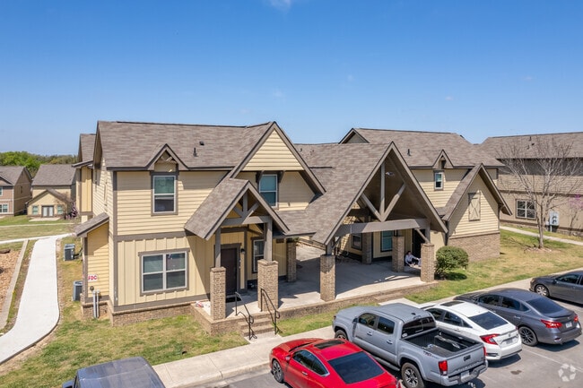

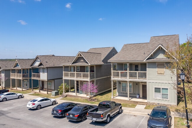
Property Detail
512 Craddock Ave
Austin-Round Rock-San Marcos, TX
THE RETREAT SUBDIVISION, LOT 1, ACRES 39.3, (AND BUSINESS PERSONAL PROPERTY)
R135856
HAYS
Apartmenthouse100plusunits
Texas
B and X Area of moderate flood hazard, usually the area between the limits of the 100-year and 500-year floods.
1
2025
39.30 AC
2025
San Marcos
010601
Austin
343,094 SF
NEARBY LISTINGS FOR SALE OR LEASE
DEMOGRAPHICS near 512 Craddock Ave
1 mile
3 mile
5 mile
2025 Total Population
12,937
50,128
78,146
2030 Population
14,689
57,203
89,600
Pop Growth 2025-2030
+ 13.54%
+ 14.11%
+ 14.66%
Average Age
30
33
33
2025 Total Households
4,619
20,420
31,726
HH Growth 2025-2030
+ 15.67%
+ 15.48%
+ 15.95%
Median Household Inc
$60,744
$49,138
$52,932
Avg Household Size
2.30
2.20
2.20
2025 Avg HH Vehicles
2.00
2.00
2.00
Median Home Value
$360,634
$358,321
$337,351
Median Year Built
1992
1994
1998
Nearby Places
Map Layers
Map Styles
 Street
 Aerial
Layers
 Traffic
 Biking
Places
Listings with unknown addresses are not visible on the map
- Restaurants
- Banks
- Shops
- Fitness
- Groceries
PUBLIC TRANSPORTATION
COMMUTER RAIL
San Marcos Amtrak (Texas Eagle - Amtrak)
Drive
Walk
Distance
San Marcos Amtrak (Texas Eagle - Amtrak)
6 min
2.3 mi
AIRPORT
Austin-Bergstrom International
Drive
Walk
Distance
Austin-Bergstrom International
51 min
37.8 mi
Freight Ports
Calhoun Port
Drive
Walk
Distance
Calhoun Port
168 min
137.2 mi
Nearby Properties
Address
Land Use
TOTAL SIZE
Lot Size
Zoning
Address
Land Use
TOTAL SIZE
Lot Size
Zoning
623,823 SF
1.46 AC
Address
Land Use
TOTAL SIZE
Lot Size
Zoning
215,932 SF
3.67 AC
Address
Land Use
TOTAL SIZE
Lot Size
Zoning
419,973 SF
23.69 AC
Address
Land Use
TOTAL SIZE
Lot Size
Zoning
458,948 SF
35.43 AC
Address
Land Use
TOTAL SIZE
Lot Size
Zoning
402,983 SF
21.31 AC
Address
Land Use
TOTAL SIZE
Lot Size
Zoning
545,643 SF
2.69 AC
Address
Land Use
TOTAL SIZE
Lot Size
Zoning
279,131 SF
22.46 AC
Address
Land Use
TOTAL SIZE
Lot Size
Zoning
352,285 SF
12.75 AC
Address
Land Use
TOTAL SIZE
Lot Size
Zoning
283,033 SF
19.46 AC
Address
Land Use
TOTAL SIZE
Lot Size
Zoning
327,917 SF
10.54 AC
Address
Land Use
TOTAL SIZE
Lot Size
Zoning
266,157 SF
14.70 AC
Address
Land Use
TOTAL SIZE
Lot Size
Zoning
215,688 SF
10.36 AC
Address
Land Use
TOTAL SIZE
Lot Size
Zoning
24.14 AC
Address
Land Use
TOTAL SIZE
Lot Size
Zoning
179,764 SF
3.27 AC
Address
Land Use
TOTAL SIZE
Lot Size
Zoning
145,336 SF
0.87 AC
Address
Land Use
TOTAL SIZE
Lot Size
Zoning
181,400 SF
13.07 AC
Address
Land Use
TOTAL SIZE
Lot Size
Zoning
211,562 SF
2.35 AC
Address
Land Use
TOTAL SIZE
Lot Size
Zoning
160,056 SF
10.05 AC
Address
Land Use
TOTAL SIZE
Lot Size
Zoning
140,844 SF
17.05 AC
Address
Land Use
TOTAL SIZE
Lot Size
Zoning
171,536 SF
8.49 AC
Address
Land Use
TOTAL SIZE
Lot Size
Zoning
178,521 SF
1.40 AC
Address
Land Use
TOTAL SIZE
Lot Size
Zoning
127,306 SF
20.85 AC
Address
Land Use
TOTAL SIZE
Lot Size
Zoning
141,735 SF
6.62 AC
Address
Land Use
TOTAL SIZE
Lot Size
Zoning
133,096 SF
0.92 AC
Address
Land Use
TOTAL SIZE
Lot Size
Zoning
296,034 SF
7.78 AC
Address
Land Use
TOTAL SIZE
Lot Size
Zoning
247,668 SF
9.08 AC
Address
Land Use
TOTAL SIZE
Lot Size
Zoning
230,979 SF
7.54 AC
Address
Land Use
TOTAL SIZE
Lot Size
Zoning
152,046 SF
8 AC
Address
Land Use
TOTAL SIZE
Lot Size
Zoning
73,658 SF
13.95 AC
The World's #1 Commercial Real Estate Marketplace
Connect with us
© 2026 CoStar Group
The information above has been obtained from sources believed reliable. While we do not doubt its accuracy we have not verified it and make no guarantee, warranty or representation about it. It is your responsibility to independently confirm its accuracy and completeness. Any projections, opinions, assumptions, or estimates used are for example only and do not represent the current or future performance of the property. The value of this transaction to you depends on tax and other factors which should be evaluated by your tax, financial, and legal advisors. You and your advisors should conduct a careful, independent investigation of the property to determine to your satisfaction the suitability of the property for your needs.