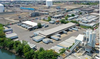
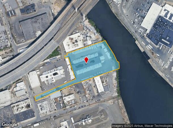
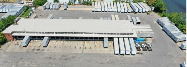
Property Record
512 Gardner Ave, Brooklyn, NY 11222

NEARBY LISTINGS FOR SALE OR LEASE
Property Detail
512 Gardner Ave
02815-0001
Kings
Warehouse
New York
AE
1
3604970206F
4.53 AC
2024
North Brooklyn
2025
Long Island (New York)
057300
New York-Jersey City-White Plains, NY-NJ
24,456 SF
DEMOGRAPHICS near 512 Gardner Ave
1 Mile
3 Mile
5 Mile
2024 Total Population
32,399
1,156,020
3,205,758
2029 Population
30,364
1,088,940
2,999,722
Pop Growth 2024-2029
(6.28%)
(5.80%)
(6.43%)
Average Age
38
38
40
2024 Total Households
13,745
476,139
1,363,712
HH Growth 2024-2029
(6.70%)
(6.16%)
(6.69%)
Median Household Inc
$88,249
$80,389
$85,981
Avg Household Size
2.20
2.30
2.20
2024 Avg HH Vehicles
1.00
.00
.00
Median Home Value
$833,917
$811,679
$871,841
Median Year Built
1947
1953
1951
Nearby Places
Map Layers
Map Styles
 Street
 Aerial
- Restaurants
- Banks
- Shops
- Fitness
- Groceries
PUBLIC TRANSPORTATION
COMMUTER RAIL
Hunterspoint Avenue Station (Hempstead Branch - Long Island Rail Road, Oyster Bay Branch - Long Island Rail Road)
DRIVE
WALK
Distance
Hunterspoint Avenue Station (Hempstead Branch - Long Island Rail Road, Oyster Bay Branch - Long Island Rail Road)
7 min
2.3 mi
Long Island City Station (Hempstead Branch - Long Island Rail Road)
DRIVE
WALK
Distance
Long Island City Station (Hempstead Branch - Long Island Rail Road)
8 min
2.7 mi
AIRPORT
LaGuardia
DRIVE
WALK
Distance
LaGuardia
13 min
6.4 mi
John F Kennedy International
DRIVE
WALK
Distance
John F Kennedy International
22 min
14.6 mi
Newark Liberty International
DRIVE
WALK
Distance
Newark Liberty International
30 min
16.5 mi
Freight Ports
NY - Red Hook Container Terminal
DRIVE
WALK
Distance
NY - Red Hook Container Terminal
13 min
6.3 mi
SALE & LEASE HISTORY
LISTING DATE
SALE/LEASE

Feb 08, 2022
For Lease
Nearby Properties
Address
Land Use
TOTAL SIZE
Lot Size
Zoning
Address
Land Use
TOTAL SIZE
Lot Size
Zoning
8,462,176 SF
61.41 AC
R7-2
Address
Land Use
TOTAL SIZE
Lot Size
Zoning
2,812,739 SF
2.10 AC
C5-3
Address
Land Use
TOTAL SIZE
Lot Size
Zoning
2,400,000 SF
15.14 AC
C5-2
Address
Land Use
TOTAL SIZE
Lot Size
Zoning
2,124,441 SF
17.29 AC
R8
Address
Land Use
TOTAL SIZE
Lot Size
Zoning
2,230,742 SF
6.33 AC
R9
Address
Land Use
TOTAL SIZE
Lot Size
Zoning
1,104,505 SF
2.32 AC
C4-7
Address
Land Use
TOTAL SIZE
Lot Size
Zoning
7,058,736 SF
147.61 AC
M3-1
Address
Land Use
TOTAL SIZE
Lot Size
Zoning
3,122,165 SF
19.02 AC
R7-2
Address
Land Use
TOTAL SIZE
Lot Size
Zoning
1,200,000 SF
10.24 AC
R9
Address
Land Use
TOTAL SIZE
Lot Size
Zoning
1,065,915 SF
2.13 AC
M16R10
Address
Land Use
TOTAL SIZE
Lot Size
Zoning
1,385,425 SF
6.43 AC
R8
Address
Land Use
TOTAL SIZE
Lot Size
Zoning
1,502,532 SF
6.35 AC
R7B
Address
Land Use
TOTAL SIZE
Lot Size
Zoning
840,000 SF
1.04 AC
C4-6
Address
Land Use
TOTAL SIZE
Lot Size
Zoning
1,503,235 SF
5.28 AC
C2-7
Address
Land Use
TOTAL SIZE
Lot Size
Zoning
805,287 SF
1 AC
R10
Address
Land Use
TOTAL SIZE
Lot Size
Zoning
986,431 SF
1.06 AC
C52.5
Address
Land Use
TOTAL SIZE
Lot Size
Zoning
666,376 SF
0.80 AC
C5-3
Address
Land Use
TOTAL SIZE
Lot Size
Zoning
2,948,300 SF
27.71 AC
R7-2
Address
Land Use
TOTAL SIZE
Lot Size
Zoning
984,760 SF
2.04 AC
M3-1
Address
Land Use
TOTAL SIZE
Lot Size
Zoning
898,734 SF
1.11 AC
C5-3
Address
Land Use
TOTAL SIZE
Lot Size
Zoning
665,110 SF
0.88 AC
C5-3
Address
Land Use
TOTAL SIZE
Lot Size
Zoning
818,726 SF
1.65 AC
C1-9
Address
Land Use
TOTAL SIZE
Lot Size
Zoning
740,301 SF
0.94 AC
C1-9
Address
Land Use
TOTAL SIZE
Lot Size
Zoning
383,780 SF
C6-2
Address
Land Use
TOTAL SIZE
Lot Size
Zoning
1,359,110 SF
1.89 AC
C5-3
Address
Land Use
TOTAL SIZE
Lot Size
Zoning
722,817 SF
3.26 AC
R8
Address
Land Use
TOTAL SIZE
Lot Size
Zoning
823,085 SF
R8
Address
Land Use
TOTAL SIZE
Lot Size
Zoning
1,658,649 SF
15.93 AC
R7-2
Address
Land Use
TOTAL SIZE
Lot Size
Zoning
768,661 SF
1.90 AC
R8B
Address
Land Use
TOTAL SIZE
Lot Size
Zoning
529,169 SF
0.68 AC
C6-6
The World's #1 Commercial Real Estate Marketplace
Connect with us
© 2026 CoStar Group
The information above has been obtained from sources believed reliable. While we do not doubt its accuracy we have not verified it and make no guarantee, warranty or representation about it. It is your responsibility to independently confirm its accuracy and completeness. Any projections, opinions, assumptions, or estimates used are for example only and do not represent the current or future performance of the property. The value of this transaction to you depends on tax and other factors which should be evaluated by your tax, financial, and legal advisors. You and your advisors should conduct a careful, independent investigation of the property to determine to your satisfaction the suitability of the property for your needs.