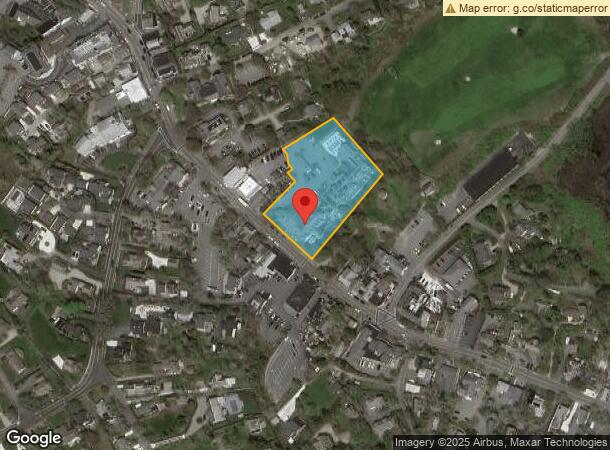
Property Record
512 Main St, Chatham, MA 02633

NEARBY LISTINGS FOR SALE OR LEASE
-
-
View all Chatham listings for sale on LoopNet.com
Property Detail
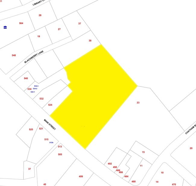
512 Main St
CHAT-000015D-000035-000080
Barnstable
Commercialnec
Massachusetts
X
80
25001C0637J
1.75 AC
2025
Cape Cod
2025
Other Market Areas
010600
Barnstable Town, MA
DEMOGRAPHICS near 512 Main St
1 mile
3 mile
5 mile
2024 Total Population
2,486
7,578
14,506
2029 Population
2,732
8,163
15,264
Pop Growth 2024-2029
+ 9.90%
+ 7.72%
+ 5.23%
Average Age
57
57
54
2024 Total Households
1,292
3,800
6,925
HH Growth 2024-2029
+ 9.83%
+ 7.76%
+ 5.31%
Median Household Inc
$98,692
$106,534
$94,425
Avg Household Size
1.90
1.90
2.00
2024 Avg HH Vehicles
2.00
2.00
2.00
Median Home Value
$1,006,522
$864,642
$741,510
Median Year Built
1980
1978
1977
Nearby Places
Map Layers
Map Styles
 Street
 Aerial
Transit
 Traffic
 Biking
Places
Listings with unknown addresses are not visible on the map
- Restaurants
- Banks
- Shops
- Fitness
- Groceries
Nearby Properties
Address
Land Use
TOTAL SIZE
Lot Size
Zoning
Address
Land Use
TOTAL SIZE
Lot Size
Zoning
2,295.68 AC
RC
Address
Land Use
TOTAL SIZE
Lot Size
Zoning
129.50 AC
R40
Address
Land Use
TOTAL SIZE
Lot Size
Zoning
129,534 SF
31.75 AC
M
Address
Land Use
TOTAL SIZE
Lot Size
Zoning
3.16 AC
R40
Address
Land Use
TOTAL SIZE
Lot Size
Zoning
7,767 SF
1.26 AC
R40
Address
Land Use
TOTAL SIZE
Lot Size
Zoning
1.90 AC
40A
Address
Land Use
TOTAL SIZE
Lot Size
Zoning
3,584 SF
2.26 AC
R40
Address
Land Use
TOTAL SIZE
Lot Size
Zoning
6.69 AC
M
Address
Land Use
TOTAL SIZE
Lot Size
Zoning
7,320 SF
1.28 AC
R40
Address
Land Use
TOTAL SIZE
Lot Size
Zoning
66.01 AC
R40
Address
Land Use
TOTAL SIZE
Lot Size
Zoning
8,261 SF
1.60 AC
R40
Address
Land Use
TOTAL SIZE
Lot Size
Zoning
6.01 AC
R40
Address
Land Use
TOTAL SIZE
Lot Size
Zoning
6,040 SF
2.17 AC
R40
Address
Land Use
TOTAL SIZE
Lot Size
Zoning
6,980 SF
1.45 AC
40A
Address
Land Use
TOTAL SIZE
Lot Size
Zoning
2.93 AC
R20
Address
Land Use
TOTAL SIZE
Lot Size
Zoning
2,597 SF
3.93 AC
R40
Address
Land Use
TOTAL SIZE
Lot Size
Zoning
3,357 SF
0.99 AC
R40
Address
Land Use
TOTAL SIZE
Lot Size
Zoning
101.55 AC
M
Address
Land Use
TOTAL SIZE
Lot Size
Zoning
57,634 SF
5.93 AC
SB
Address
Land Use
TOTAL SIZE
Lot Size
Zoning
72.55 AC
R60
Address
Land Use
TOTAL SIZE
Lot Size
Zoning
80 AC
M
Address
Land Use
TOTAL SIZE
Lot Size
Zoning
1,880 SF
R40
Address
Land Use
TOTAL SIZE
Lot Size
Zoning
7,387 SF
1.76 AC
R40
Address
Land Use
TOTAL SIZE
Lot Size
Zoning
8,574 SF
4.39 AC
R40
Address
Land Use
TOTAL SIZE
Lot Size
Zoning
4.33 AC
R40
Address
Land Use
TOTAL SIZE
Lot Size
Zoning
5.23 AC
R40
Address
Land Use
TOTAL SIZE
Lot Size
Zoning
2,321 SF
1.29 AC
R40
Address
Land Use
TOTAL SIZE
Lot Size
Zoning
6,714 SF
0.69 AC
R40
Address
Land Use
TOTAL SIZE
Lot Size
Zoning
3 AC
RC
Address
Land Use
TOTAL SIZE
Lot Size
Zoning
3,992 SF
0.54 AC
R40
The World's #1 Commercial Real Estate Marketplace
Connect with us
© 2026 CoStar Group
The information above has been obtained from sources believed reliable. While we do not doubt its accuracy we have not verified it and make no guarantee, warranty or representation about it. It is your responsibility to independently confirm its accuracy and completeness. Any projections, opinions, assumptions, or estimates used are for example only and do not represent the current or future performance of the property. The value of this transaction to you depends on tax and other factors which should be evaluated by your tax, financial, and legal advisors. You and your advisors should conduct a careful, independent investigation of the property to determine to your satisfaction the suitability of the property for your needs.