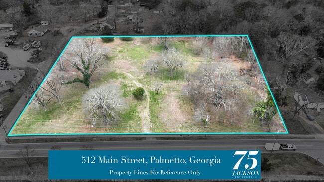
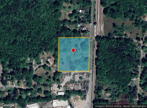
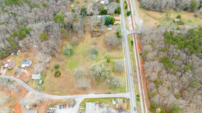
Property Record
512 Main St, Palmetto, GA 30268

NEARBY LISTINGS FOR SALE OR LEASE
Property Detail
512 Main St
Atlanta-Sandy Springs-Roswell, GA
Plat/Same Cswy Gates Surv
07-3510-0063-009-7
VACANT LOT 11/12
Commercialacreage
Fulton
X
Georgia
13121C0443F
11
2024
4.30 AC
2025
North Clayton/Airport
010402
Atlanta
DEMOGRAPHICS near 512 Main St
1 Mile
3 Mile
5 Mile
2024 Total Population
1,990
11,928
30,810
2029 Population
2,142
12,933
33,236
Pop Growth 2024-2029
+ 7.64%
+ 8.43%
+ 7.87%
Average Age
41
39
40
2024 Total Households
769
4,236
10,823
HH Growth 2024-2029
+ 7.54%
+ 8.38%
+ 7.91%
Median Household Inc
$57,399
$71,965
$82,843
Avg Household Size
2.60
2.80
2.80
2024 Avg HH Vehicles
1.00
2.00
2.00
Median Home Value
$155,035
$311,938
$325,724
Median Year Built
1985
1998
1998
Nearby Places
Map Layers
Map Styles
 Street
 Aerial
- Restaurants
- Banks
- Shops
- Fitness
- Groceries
PUBLIC TRANSPORTATION
AIRPORT
Hartsfield - Jackson Atlanta International
DRIVE
WALK
Distance
Hartsfield - Jackson Atlanta International
32 min
21.8 mi
Freight Ports
Georgia Ports - Savannah
DRIVE
WALK
Distance
Georgia Ports - Savannah
294 min
259.1 mi
SALE & LEASE HISTORY
LISTING DATE
SALE/LEASE

Mar 07, 2024
For Sale
Nearby Properties
Address
Land Use
TOTAL SIZE
Lot Size
Zoning
Address
Land Use
TOTAL SIZE
Lot Size
Zoning
1,000,200 SF
78.26 AC
R1
Address
Land Use
TOTAL SIZE
Lot Size
Zoning
79.51 AC
AG1
Address
Land Use
TOTAL SIZE
Lot Size
Zoning
374,881 SF
91.05 AC
M1
Address
Land Use
TOTAL SIZE
Lot Size
Zoning
1,094,400 SF
111.68 AC
M1
Address
Land Use
TOTAL SIZE
Lot Size
Zoning
981,874 SF
83.45 AC
AG1
Address
Land Use
TOTAL SIZE
Lot Size
Zoning
1,351,440 SF
86.29 AC
M1
Address
Land Use
TOTAL SIZE
Lot Size
Zoning
1,054,500 SF
101.73 AC
M1
Address
Land Use
TOTAL SIZE
Lot Size
Zoning
1,064,460 SF
23.50 AC
M2
Address
Land Use
TOTAL SIZE
Lot Size
Zoning
293,156 SF
59.97 AC
R1
Address
Land Use
TOTAL SIZE
Lot Size
Zoning
685,260 SF
56.60 AC
M1
Address
Land Use
TOTAL SIZE
Lot Size
Zoning
48.74 AC
M1
Address
Land Use
TOTAL SIZE
Lot Size
Zoning
300,000 SF
66.47 AC
R1
Address
Land Use
TOTAL SIZE
Lot Size
Zoning
374,881 SF
34.73 AC
M1
Address
Land Use
TOTAL SIZE
Lot Size
Zoning
74.16 AC
R1
Address
Land Use
TOTAL SIZE
Lot Size
Zoning
139,164 SF
48.66 AC
R2
Address
Land Use
TOTAL SIZE
Lot Size
Zoning
201,600 SF
18 AC
M1
Address
Land Use
TOTAL SIZE
Lot Size
Zoning
255,000 SF
20.68 AC
M1
Address
Land Use
TOTAL SIZE
Lot Size
Zoning
39.33 AC
M2
Address
Land Use
TOTAL SIZE
Lot Size
Zoning
45,256 SF
20.15 AC
M
Address
Land Use
TOTAL SIZE
Lot Size
Zoning
Address
Land Use
TOTAL SIZE
Lot Size
Zoning
102.42 AC
AG1
Address
Land Use
TOTAL SIZE
Lot Size
Zoning
29,800 SF
16.70 AC
R2
Address
Land Use
TOTAL SIZE
Lot Size
Zoning
33,553 SF
274.48 AC
R1
Address
Land Use
TOTAL SIZE
Lot Size
Zoning
2,979 SF
132 AC
C3
Address
Land Use
TOTAL SIZE
Lot Size
Zoning
86.10 AC
AG1
Address
Land Use
TOTAL SIZE
Lot Size
Zoning
12,008 SF
12.19 AC
RL
Address
Land Use
TOTAL SIZE
Lot Size
Zoning
436,508 SF
16.03 AC
R7
Address
Land Use
TOTAL SIZE
Lot Size
Zoning
14.98 AC
AG1
Address
Land Use
TOTAL SIZE
Lot Size
Zoning
40,360 SF
12.29 AC
R2
Address
Land Use
TOTAL SIZE
Lot Size
Zoning
7,252 SF
1.69 AC
The World's #1 Commercial Real Estate Marketplace
Connect with us
© 2025 CoStar Group
The information above has been obtained from sources believed reliable. While we do not doubt its accuracy we have not verified it and make no guarantee, warranty or representation about it. It is your responsibility to independently confirm its accuracy and completeness. Any projections, opinions, assumptions, or estimates used are for example only and do not represent the current or future performance of the property. The value of this transaction to you depends on tax and other factors which should be evaluated by your tax, financial, and legal advisors. You and your advisors should conduct a careful, independent investigation of the property to determine to your satisfaction the suitability of the property for your needs.