Property Record
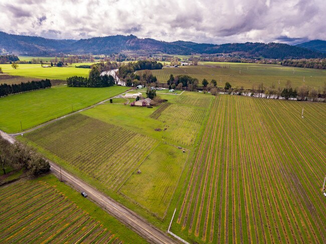
512 N Curry Rd, Roseburg, OR 97471


Property Detail
512 N Curry Rd
R16740
N CURRY EST PLAT B, BLOCK 1, LOT PT 11, ACRES 15.08
Farms
DOUGLAS
F1
Oregon
A Areas with a 1% annual chance of flooding and a 26% chance of flooding over the life of a 30-year mortgage.
11
2025
15.08 AC
2025
Oregon West Area
080001
Other Market Areas
4,131 SF
Roseburg, OR
NEARBY LISTINGS FOR SALE OR LEASE
-
-
View all Roseburg listings for sale on LoopNet.com
DEMOGRAPHICS near 512 N Curry Rd
1 mile
3 mile
5 mile
2025 Total Population
198
4,087
21,633
2030 Population
192
3,932
21,537
Pop Growth 2025-2030
(3.03%)
(3.79%)
(0.44%)
Average Age
50
50
47
2025 Total Households
78
1,612
8,902
HH Growth 2025-2030
(2.56%)
(3.85%)
(0.38%)
Median Household Inc
$110,000
$108,630
$75,892
Avg Household Size
2.50
2.50
2.30
2025 Avg HH Vehicles
3.00
3.00
2.00
Median Home Value
$611,111
$585,635
$387,935
Median Year Built
1978
1976
1979
Nearby Places
Map Layers
Map Styles
 Street
 Aerial
Layers
 Traffic
 Biking
Places
Listings with unknown addresses are not visible on the map
- Restaurants
- Banks
- Shops
- Fitness
- Groceries
SALE & LEASE HISTORY
LISTING DATE
SALE/LEASE

Apr 17, 2019
For Sale
Nearby Properties
Address
Land Use
TOTAL SIZE
Lot Size
Zoning
Address
Land Use
TOTAL SIZE
Lot Size
Zoning
4.39 AC
PR
Address
Land Use
TOTAL SIZE
Lot Size
Zoning
4,999 SF
21.85 AC
F1
Address
Land Use
TOTAL SIZE
Lot Size
Zoning
22,858 SF
24.47 AC
PR
Address
Land Use
TOTAL SIZE
Lot Size
Zoning
30,130 SF
8.85 AC
5R
Address
Land Use
TOTAL SIZE
Lot Size
Zoning
7,932 SF
10.30 AC
5R
Address
Land Use
TOTAL SIZE
Lot Size
Zoning
8,111 SF
6.17 AC
F1
Address
Land Use
TOTAL SIZE
Lot Size
Zoning
6,300 SF
89.08 AC
5R
Address
Land Use
TOTAL SIZE
Lot Size
Zoning
8,660 SF
98.43 AC
FG
Address
Land Use
TOTAL SIZE
Lot Size
Zoning
29,531 SF
8.49 AC
PR
Address
Land Use
TOTAL SIZE
Lot Size
Zoning
6,233 SF
29.43 AC
5R
Address
Land Use
TOTAL SIZE
Lot Size
Zoning
8,149 SF
5 AC
FG
Address
Land Use
TOTAL SIZE
Lot Size
Zoning
5,902 SF
7.83 AC
F1
Address
Land Use
TOTAL SIZE
Lot Size
Zoning
9.47 AC
PR
Address
Land Use
TOTAL SIZE
Lot Size
Zoning
8,776 SF
80.10 AC
FG
Address
Land Use
TOTAL SIZE
Lot Size
Zoning
Address
Land Use
TOTAL SIZE
Lot Size
Zoning
18.71 AC
PR
Address
Land Use
TOTAL SIZE
Lot Size
Zoning
17,967 SF
0.52 AC
5R
Address
Land Use
TOTAL SIZE
Lot Size
Zoning
6,426 SF
5 AC
FG
Address
Land Use
TOTAL SIZE
Lot Size
Zoning
11,615 SF
6.22 AC
5R
Address
Land Use
TOTAL SIZE
Lot Size
Zoning
5,234 SF
5.15 AC
5R
Address
Land Use
TOTAL SIZE
Lot Size
Zoning
6,689 SF
5 AC
FG
Address
Land Use
TOTAL SIZE
Lot Size
Zoning
5,101 SF
84 AC
F1
Address
Land Use
TOTAL SIZE
Lot Size
Zoning
6,081 SF
2.12 AC
F1
Address
Land Use
TOTAL SIZE
Lot Size
Zoning
3,200 SF
13.69 AC
PR
Address
Land Use
TOTAL SIZE
Lot Size
Zoning
5,570 SF
21.08 AC
F1
Address
Land Use
TOTAL SIZE
Lot Size
Zoning
7,049 SF
10.10 AC
F1
Address
Land Use
TOTAL SIZE
Lot Size
Zoning
11,250 SF
19.64 AC
PR
Address
Land Use
TOTAL SIZE
Lot Size
Zoning
6,573 SF
5 AC
FG
Address
Land Use
TOTAL SIZE
Lot Size
Zoning
3,040 SF
2.31 AC
F1
Address
Land Use
TOTAL SIZE
Lot Size
Zoning
4,660 SF
5 AC
FG
The World's #1 Commercial Real Estate Marketplace
Connect with us
© 2026 CoStar Group
The information above has been obtained from sources believed reliable. While we do not doubt its accuracy we have not verified it and make no guarantee, warranty or representation about it. It is your responsibility to independently confirm its accuracy and completeness. Any projections, opinions, assumptions, or estimates used are for example only and do not represent the current or future performance of the property. The value of this transaction to you depends on tax and other factors which should be evaluated by your tax, financial, and legal advisors. You and your advisors should conduct a careful, independent investigation of the property to determine to your satisfaction the suitability of the property for your needs.