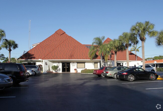
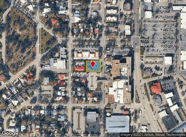
Property Record
512 Nokomis Ave S, Venice, FL 34285

NEARBY LISTINGS FOR SALE OR LEASE
Property Detail
512 Nokomis Ave S
North Port-Sarasota-Bradenton, FL
Venezia Park Sec Of Venice
0429-06-0045
LOTS 1 & 2 & N 17 FT OF LOT 3 BLK 103 VENEZIA PARK SEC OF VENICE
Medicalbuilding
Sarasota
X
Florida
12115C0329G
1,2,3
2024
0.43 AC
2025
Sarasota
002401
Tampa/St Petersburg
5,650 SF
DEMOGRAPHICS near 512 Nokomis Ave S
1 Mile
3 Mile
5 Mile
2024 Total Population
9,314
44,095
83,439
2029 Population
11,028
51,518
96,902
Pop Growth 2024-2029
+ 18.40%
+ 16.83%
+ 16.14%
Average Age
63
60
58
2024 Total Households
5,188
23,041
42,163
HH Growth 2024-2029
+ 18.47%
+ 16.98%
+ 16.23%
Median Household Inc
$58,028
$62,346
$67,247
Avg Household Size
1.70
1.80
1.90
2024 Avg HH Vehicles
1.00
1.00
2.00
Median Home Value
$411,028
$296,510
$313,807
Median Year Built
1973
1978
1984
Nearby Places
Map Layers
Map Styles
 Street
 Aerial
- Restaurants
- Banks
- Shops
- Fitness
- Groceries
PUBLIC TRANSPORTATION
AIRPORT
Sarasota/Bradenton International
DRIVE
WALK
Distance
Sarasota/Bradenton International
43 min
24.0 mi
Freight Ports
Port Manatee
DRIVE
WALK
Distance
Port Manatee
56 min
42.2 mi
Nearby Properties
Address
Land Use
TOTAL SIZE
Lot Size
Zoning
Address
Land Use
TOTAL SIZE
Lot Size
Zoning
26,265 SF
210.50 AC
RMH
Address
Land Use
TOTAL SIZE
Lot Size
Zoning
592,021 SF
75.99 AC
G
Address
Land Use
TOTAL SIZE
Lot Size
Zoning
565,625 SF
15.61 AC
ST2A
Address
Land Use
TOTAL SIZE
Lot Size
Zoning
421,272 SF
31.96 AC
PUD
Address
Land Use
TOTAL SIZE
Lot Size
Zoning
23,348 SF
77.03 AC
RMH
Address
Land Use
TOTAL SIZE
Lot Size
Zoning
190,485 SF
5.81 AC
NTG
Address
Land Use
TOTAL SIZE
Lot Size
Zoning
183,584 SF
14.54 AC
PUD
Address
Land Use
TOTAL SIZE
Lot Size
Zoning
223,397 SF
453.78 AC
G
Address
Land Use
TOTAL SIZE
Lot Size
Zoning
133,773 SF
6.29 AC
OPI
Address
Land Use
TOTAL SIZE
Lot Size
Zoning
5,396 SF
33.59 AC
RMH
Address
Land Use
TOTAL SIZE
Lot Size
Zoning
5,208 SF
38.03 AC
CG
Address
Land Use
TOTAL SIZE
Lot Size
Zoning
63,549 SF
6.26 AC
OPI
Address
Land Use
TOTAL SIZE
Lot Size
Zoning
111,306 SF
9.35 AC
CSC
Address
Land Use
TOTAL SIZE
Lot Size
Zoning
138,547 SF
18.63 AC
CSC
Address
Land Use
TOTAL SIZE
Lot Size
Zoning
66,899 SF
30.10 AC
GU
Address
Land Use
TOTAL SIZE
Lot Size
Zoning
121,747 SF
17.54 AC
OUE1
Address
Land Use
TOTAL SIZE
Lot Size
Zoning
101,219 SF
4.90 AC
OPI
Address
Land Use
TOTAL SIZE
Lot Size
Zoning
112,415 SF
8.77 AC
CSC
Address
Land Use
TOTAL SIZE
Lot Size
Zoning
76,247 SF
13.89 AC
CG
Address
Land Use
TOTAL SIZE
Lot Size
Zoning
3,447 SF
65.66 AC
ROS
Address
Land Use
TOTAL SIZE
Lot Size
Zoning
45,837 SF
3.06 AC
G
Address
Land Use
TOTAL SIZE
Lot Size
Zoning
139,551 SF
14.60 AC
CSC
Address
Land Use
TOTAL SIZE
Lot Size
Zoning
55,417 SF
5.64 AC
CG
Address
Land Use
TOTAL SIZE
Lot Size
Zoning
114,693 SF
15.16 AC
PUD
Address
Land Use
TOTAL SIZE
Lot Size
Zoning
30,560 SF
9.92 AC
G
Address
Land Use
TOTAL SIZE
Lot Size
Zoning
59,645 SF
2.68 AC
CG
Address
Land Use
TOTAL SIZE
Lot Size
Zoning
30,553 SF
5.03 AC
G
Address
Land Use
TOTAL SIZE
Lot Size
Zoning
100,001 SF
5.14 AC
CG
Address
Land Use
TOTAL SIZE
Lot Size
Zoning
61,332 SF
8.25 AC
ST2
Address
Land Use
TOTAL SIZE
Lot Size
Zoning
46,327 SF
75.56 AC
ROS
The World's #1 Commercial Real Estate Marketplace
Connect with us
© 2025 CoStar Group
The information above has been obtained from sources believed reliable. While we do not doubt its accuracy we have not verified it and make no guarantee, warranty or representation about it. It is your responsibility to independently confirm its accuracy and completeness. Any projections, opinions, assumptions, or estimates used are for example only and do not represent the current or future performance of the property. The value of this transaction to you depends on tax and other factors which should be evaluated by your tax, financial, and legal advisors. You and your advisors should conduct a careful, independent investigation of the property to determine to your satisfaction the suitability of the property for your needs.