Property Record
512 S Main St, Calvert, TX 77837


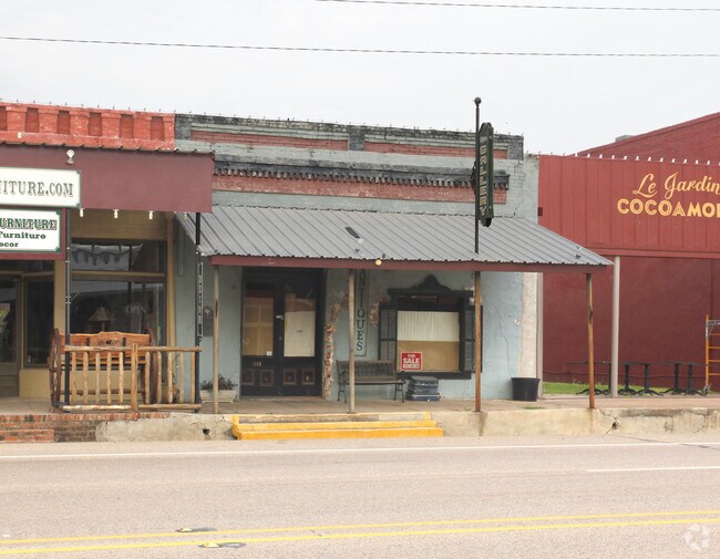
Property Detail
512 S Main St
College Station-Bryan, TX
S 1/2 OF LT 2 BL 26 CALVERT 1379/351 0.086 ACRES
030000-003380
Robertson
Commercialnec
Texas
B and X Area of moderate flood hazard, usually the area between the limits of the 100-year and 500-year floods.
2
2025
0.09 AC
2025
Bryan & College Station
960200
Other Market Areas
900 SF
NEARBY LISTINGS FOR SALE OR LEASE
-
-
View all Calvert listings for sale on LoopNet.com
DEMOGRAPHICS near 512 S Main St
1 mile
3 mile
5 mile
2024 Total Population
684
887
1,057
2029 Population
676
873
1,051
Pop Growth 2024-2029
(1.17%)
(1.58%)
(0.57%)
Average Age
46
46
45
2024 Total Households
299
388
455
HH Growth 2024-2029
(1.00%)
(1.55%)
(0.66%)
Median Household Inc
$64,239
$64,355
$64,375
Avg Household Size
2.30
2.30
2.30
2024 Avg HH Vehicles
2.00
2.00
2.00
Median Home Value
$155,454
$157,246
$158,749
Median Year Built
1973
1974
1975
Nearby Places
Map Layers
Map Styles
 Street
 Aerial
Transit
 Traffic
 Biking
Places
Listings with unknown addresses are not visible on the map
- Restaurants
- Banks
- Shops
- Fitness
- Groceries
SALE & LEASE HISTORY
LISTING DATE
SALE/LEASE

Mar 17, 2017
For Sale
Nearby Properties
Address
Land Use
TOTAL SIZE
Lot Size
Zoning
Address
Land Use
TOTAL SIZE
Lot Size
Zoning
61,585 SF
10 AC
Address
Land Use
TOTAL SIZE
Lot Size
Zoning
1,008 SF
159.19 AC
Address
Land Use
TOTAL SIZE
Lot Size
Zoning
4,422 SF
66.03 AC
Address
Land Use
TOTAL SIZE
Lot Size
Zoning
2,365 SF
0.40 AC
Address
Land Use
TOTAL SIZE
Lot Size
Zoning
3,237 SF
18.18 AC
Address
Land Use
TOTAL SIZE
Lot Size
Zoning
8,320 SF
1.35 AC
Address
Land Use
TOTAL SIZE
Lot Size
Zoning
3,063 SF
0.33 AC
Address
Land Use
TOTAL SIZE
Lot Size
Zoning
2,640 SF
0.45 AC
Address
Land Use
TOTAL SIZE
Lot Size
Zoning
480 SF
51.20 AC
Address
Land Use
TOTAL SIZE
Lot Size
Zoning
13,200 SF
0.13 AC
Address
Land Use
TOTAL SIZE
Lot Size
Zoning
12,222 SF
9.39 AC
Address
Land Use
TOTAL SIZE
Lot Size
Zoning
4,184 SF
1.44 AC
Address
Land Use
TOTAL SIZE
Lot Size
Zoning
16,756 SF
3.59 AC
Address
Land Use
TOTAL SIZE
Lot Size
Zoning
4,085 SF
1.21 AC
Address
Land Use
TOTAL SIZE
Lot Size
Zoning
2,952 SF
5.22 AC
Address
Land Use
TOTAL SIZE
Lot Size
Zoning
13.92 AC
Address
Land Use
TOTAL SIZE
Lot Size
Zoning
2,976 SF
2 AC
Address
Land Use
TOTAL SIZE
Lot Size
Zoning
2,296 SF
583.70 AC
Address
Land Use
TOTAL SIZE
Lot Size
Zoning
64.61 AC
Address
Land Use
TOTAL SIZE
Lot Size
Zoning
2,720 SF
7.80 AC
Address
Land Use
TOTAL SIZE
Lot Size
Zoning
2,191 SF
12.71 AC
Address
Land Use
TOTAL SIZE
Lot Size
Zoning
2,300 SF
3.32 AC
Address
Land Use
TOTAL SIZE
Lot Size
Zoning
4,684 SF
0.66 AC
Address
Land Use
TOTAL SIZE
Lot Size
Zoning
2,484 SF
0.46 AC
Address
Land Use
TOTAL SIZE
Lot Size
Zoning
1,400 SF
2.26 AC
Address
Land Use
TOTAL SIZE
Lot Size
Zoning
6,639 SF
1.72 AC
Address
Land Use
TOTAL SIZE
Lot Size
Zoning
850 SF
0.07 AC
Address
Land Use
TOTAL SIZE
Lot Size
Zoning
1,680 SF
0.12 AC
Address
Land Use
TOTAL SIZE
Lot Size
Zoning
1,450 SF
0.03 AC
The World's #1 Commercial Real Estate Marketplace
Connect with us
© 2026 CoStar Group
The information above has been obtained from sources believed reliable. While we do not doubt its accuracy we have not verified it and make no guarantee, warranty or representation about it. It is your responsibility to independently confirm its accuracy and completeness. Any projections, opinions, assumptions, or estimates used are for example only and do not represent the current or future performance of the property. The value of this transaction to you depends on tax and other factors which should be evaluated by your tax, financial, and legal advisors. You and your advisors should conduct a careful, independent investigation of the property to determine to your satisfaction the suitability of the property for your needs.