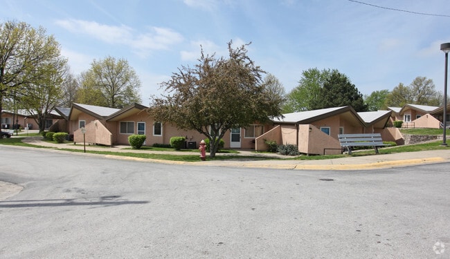
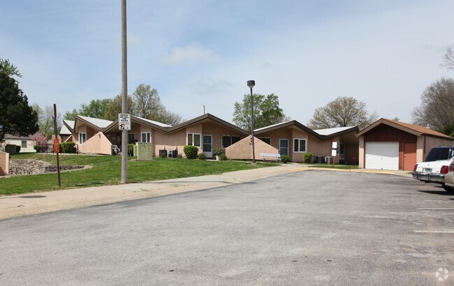
Property Record
5120 Leavenworth Rd, Kansas City, KS 66104

NEARBY LISTINGS FOR SALE OR LEASE
-
-
View all Kansas City listings for sale on LoopNet.com
Property Detail
5120 Leavenworth Rd
917627
SEC-26 TWP-10 RNG-24, S26, T10, R24, ACRES 4.410000, 262D2-1 BEG 195W & 30N SE COR SE1/4 W389.53,N200,E100,N507.63,S 57E-85.67,S23.71,S57E- 314.50,SELY 142.04 TO W LN 51ST,S61.66,NWLY 199.55,S 439.31, TO POB CONTG 4.655 AC
Apartment
Wyandotte
X
Kansas
29095C0125G
4.72 AC
0
Quindaro Bluffs
2025
Kansas City
044500
Kansas City, MO-KS
31,185 SF
DEMOGRAPHICS near 5120 Leavenworth Rd
1 Mile
3 Mile
5 Mile
2024 Total Population
6,622
43,764
117,217
2029 Population
6,443
42,826
116,623
Pop Growth 2024-2029
(2.70%)
(2.14%)
(0.51%)
Average Age
38
36
37
2024 Total Households
2,378
15,201
41,486
HH Growth 2024-2029
(2.73%)
(2.18%)
(0.45%)
Median Household Inc
$54,774
$52,586
$53,518
Avg Household Size
2.60
2.70
2.70
2024 Avg HH Vehicles
2.00
2.00
2.00
Median Home Value
$130,931
$118,378
$141,522
Median Year Built
1957
1957
1960
Nearby Places
Map Layers
Map Styles
 Street
 Aerial
- Restaurants
- Banks
- Shops
- Fitness
- Groceries
PUBLIC TRANSPORTATION
AIRPORT
Kansas City International
DRIVE
WALK
Distance
Kansas City International
24 min
18.3 mi
Freight Ports
Tulsa Port Of Catoosa
DRIVE
WALK
Distance
Tulsa Port Of Catoosa
269 min
239.7 mi
Nearby Properties
Address
Land Use
TOTAL SIZE
Lot Size
Zoning
Address
Land Use
TOTAL SIZE
Lot Size
Zoning
264,254 SF
56.62 AC
KR1
Address
Land Use
TOTAL SIZE
Lot Size
Zoning
346,224 SF
28.44 AC
Address
Land Use
TOTAL SIZE
Lot Size
Zoning
241,816 SF
20.03 AC
Address
Land Use
TOTAL SIZE
Lot Size
Zoning
224,020 SF
24.72 AC
KR1
Address
Land Use
TOTAL SIZE
Lot Size
Zoning
88,396 SF
23.79 AC
Address
Land Use
TOTAL SIZE
Lot Size
Zoning
139,499 SF
20.51 AC
KR1B
Address
Land Use
TOTAL SIZE
Lot Size
Zoning
71,326 SF
6.31 AC
KR1
Address
Land Use
TOTAL SIZE
Lot Size
Zoning
75,309 SF
19.40 AC
KR1
Address
Land Use
TOTAL SIZE
Lot Size
Zoning
54,578 SF
12.01 AC
KR1
Address
Land Use
TOTAL SIZE
Lot Size
Zoning
139,495 SF
35.01 AC
KR1
Address
Land Use
TOTAL SIZE
Lot Size
Zoning
158,011 SF
26.66 AC
Address
Land Use
TOTAL SIZE
Lot Size
Zoning
39,641 SF
70.67 AC
Address
Land Use
TOTAL SIZE
Lot Size
Zoning
132,724 SF
20.84 AC
KC1
Address
Land Use
TOTAL SIZE
Lot Size
Zoning
45,968 SF
2.58 AC
KR2
Address
Land Use
TOTAL SIZE
Lot Size
Zoning
207,491 SF
616.94 AC
KR1
Address
Land Use
TOTAL SIZE
Lot Size
Zoning
62,068 SF
17.75 AC
KR1
Address
Land Use
TOTAL SIZE
Lot Size
Zoning
656,640 SF
20.07 AC
Address
Land Use
TOTAL SIZE
Lot Size
Zoning
53,029 SF
6.50 AC
KR1B
Address
Land Use
TOTAL SIZE
Lot Size
Zoning
39,588 SF
16.33 AC
KR1
Address
Land Use
TOTAL SIZE
Lot Size
Zoning
43,922 SF
5.81 AC
Address
Land Use
TOTAL SIZE
Lot Size
Zoning
221,952 SF
28.85 AC
Address
Land Use
TOTAL SIZE
Lot Size
Zoning
9,700 SF
3.30 AC
KRP5
Address
Land Use
TOTAL SIZE
Lot Size
Zoning
37,210 SF
7.50 AC
Address
Land Use
TOTAL SIZE
Lot Size
Zoning
36,356 SF
5.36 AC
KR1
Address
Land Use
TOTAL SIZE
Lot Size
Zoning
24,536 SF
28.55 AC
KR1B
Address
Land Use
TOTAL SIZE
Lot Size
Zoning
39,221 SF
10.44 AC
Address
Land Use
TOTAL SIZE
Lot Size
Zoning
30,520 SF
7.03 AC
KRP5
Address
Land Use
TOTAL SIZE
Lot Size
Zoning
34,309 SF
1.78 AC
KR1B
Address
Land Use
TOTAL SIZE
Lot Size
Zoning
43,208 SF
4.14 AC
The World's #1 Commercial Real Estate Marketplace
Connect with us
© 2026 CoStar Group
The information above has been obtained from sources believed reliable. While we do not doubt its accuracy we have not verified it and make no guarantee, warranty or representation about it. It is your responsibility to independently confirm its accuracy and completeness. Any projections, opinions, assumptions, or estimates used are for example only and do not represent the current or future performance of the property. The value of this transaction to you depends on tax and other factors which should be evaluated by your tax, financial, and legal advisors. You and your advisors should conduct a careful, independent investigation of the property to determine to your satisfaction the suitability of the property for your needs.