Property Record
5120 Osage St, Denver, CO 80221


Current Lease Availabilities
NEARBY LISTINGS FOR SALE OR LEASE
Property Detail
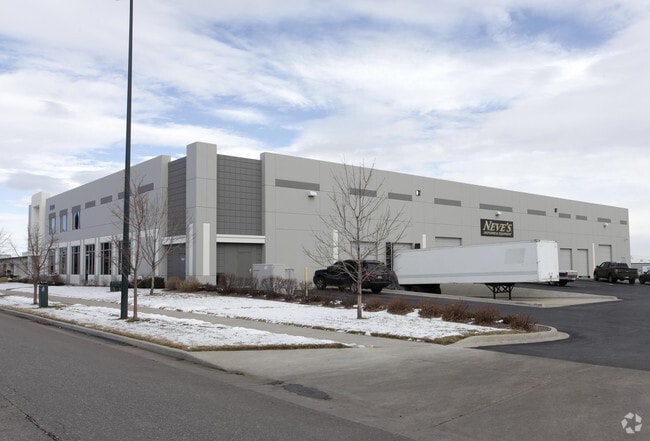
5120 Osage St
Denver-Aurora-Lakewood, CO
West 48Th Avenue Industrial District 1St
2164-09-027
WEST 48TH AVENUE INDUSTRIAL DISTRICT 1ST FLG PT L4 BEG 433.87FT S OF NW COR L4 E 230FT S 380FT W 230FT N 380FT POB
Warehouse
Denver
X
Colorado
08059C0220F
4
2024
2.01 AC
2024
Upper North Central
000201
Denver
28,735 SF
DEMOGRAPHICS near 5120 Osage St
1 Mile
3 Mile
5 Mile
2024 Total Population
9,688
142,000
424,190
2029 Population
9,877
145,470
432,253
Pop Growth 2024-2029
+ 1.95%
+ 2.44%
+ 1.90%
Average Age
39
37
38
2024 Total Households
3,732
66,450
194,618
HH Growth 2024-2029
+ 1.71%
+ 2.41%
+ 1.86%
Median Household Inc
$80,179
$90,973
$76,655
Avg Household Size
2.50
2.00
2.10
2024 Avg HH Vehicles
2.00
2.00
2.00
Median Home Value
$488,546
$613,767
$503,831
Median Year Built
1956
1984
1970
Nearby Places
Map Layers
Map Styles
 Street
 Aerial
- Restaurants
- Banks
- Shops
- Fitness
- Groceries
PUBLIC TRANSPORTATION
COMMUTER RAIL
Pecos Junction Station Track 1 (Union Station to Westminster Station - Regional Transportation District, Union Station to Wheat Ridge Ward Station - Regional Transportation District)
DRIVE
WALK
Distance
Pecos Junction Station Track 1 (Union Station to Westminster Station - Regional Transportation District, Union Station to Wheat Ridge Ward Station - Regional Transportation District)
3 min
1.3 mi
41St & Fox Station Track 1 (Union Station to Westminster Station - Regional Transportation District, Union Station to Wheat Ridge Ward Station - Regional Transportation District)
DRIVE
WALK
Distance
41St & Fox Station Track 1 (Union Station to Westminster Station - Regional Transportation District, Union Station to Wheat Ridge Ward Station - Regional Transportation District)
6 min
2.7 mi
AIRPORT
Denver International
DRIVE
WALK
Distance
Denver International
30 min
23.7 mi
Freight Ports
Tulsa Port Of Catoosa
DRIVE
WALK
Distance
Tulsa Port Of Catoosa
728 min
709.2 mi
Nearby Properties
Address
Land Use
TOTAL SIZE
Lot Size
Zoning
Address
Land Use
TOTAL SIZE
Lot Size
Zoning
794,383 SF
0.90 AC
D-TD
Address
Land Use
TOTAL SIZE
Lot Size
Zoning
545,292 SF
1.15 AC
D-C
Address
Land Use
TOTAL SIZE
Lot Size
Zoning
611,828 SF
0.94 AC
PUD
Address
Land Use
TOTAL SIZE
Lot Size
Zoning
150,202 SF
13.24 AC
T-MU-30
Address
Land Use
TOTAL SIZE
Lot Size
Zoning
337,495 SF
0.57 AC
D-C
Address
Land Use
TOTAL SIZE
Lot Size
Zoning
858,528 SF
2.53 AC
D-C
Address
Land Use
TOTAL SIZE
Lot Size
Zoning
755,793 SF
2.44 AC
D-C
Address
Land Use
TOTAL SIZE
Lot Size
Zoning
298,387 SF
0.88 AC
PUD
Address
Land Use
TOTAL SIZE
Lot Size
Zoning
724,981 SF
1.26 AC
D-C
Address
Land Use
TOTAL SIZE
Lot Size
Zoning
405,974 SF
1.78 AC
PUD
Address
Land Use
TOTAL SIZE
Lot Size
Zoning
1,018,386 SF
2.46 AC
D-C
Address
Land Use
TOTAL SIZE
Lot Size
Zoning
290,821 SF
1.16 AC
PUD
Address
Land Use
TOTAL SIZE
Lot Size
Zoning
716,151 SF
2.45 AC
D-C
Address
Land Use
TOTAL SIZE
Lot Size
Zoning
618,768 SF
1.23 AC
D-C
Address
Land Use
TOTAL SIZE
Lot Size
Zoning
334,746 SF
1.25 AC
D-LD
Address
Land Use
TOTAL SIZE
Lot Size
Zoning
888,385 SF
20.40 AC
I-A
Address
Land Use
TOTAL SIZE
Lot Size
Zoning
860,132 SF
68.50 AC
R-5
Address
Land Use
TOTAL SIZE
Lot Size
Zoning
424,862 SF
32.28 AC
G-MU-3
Address
Land Use
TOTAL SIZE
Lot Size
Zoning
572,915 SF
1.52 AC
D-TD
Address
Land Use
TOTAL SIZE
Lot Size
Zoning
303,752 SF
1.26 AC
D-LD
Address
Land Use
TOTAL SIZE
Lot Size
Zoning
729,679 SF
C-MX
Address
Land Use
TOTAL SIZE
Lot Size
Zoning
281,209 SF
1.66 AC
C-MX-12
Address
Land Use
TOTAL SIZE
Lot Size
Zoning
507,837 SF
1.53 AC
D-C
Address
Land Use
TOTAL SIZE
Lot Size
Zoning
225,749 SF
1.27 AC
D-LD
Address
Land Use
TOTAL SIZE
Lot Size
Zoning
499,472 SF
0.96 AC
CBT
Address
Land Use
TOTAL SIZE
Lot Size
Zoning
357,365 SF
0.53 AC
D-TD
Address
Land Use
TOTAL SIZE
Lot Size
Zoning
635,895 SF
2.45 AC
D-C
Address
Land Use
TOTAL SIZE
Lot Size
Zoning
218,176 SF
0.62 AC
T-MU-30
Address
Land Use
TOTAL SIZE
Lot Size
Zoning
265,054 SF
1.39 AC
C-MX-5
Address
Land Use
TOTAL SIZE
Lot Size
Zoning
203,148 SF
1.36 AC
C-MX-5
The World's #1 Commercial Real Estate Marketplace
Connect with us
© 2026 CoStar Group
The information above has been obtained from sources believed reliable. While we do not doubt its accuracy we have not verified it and make no guarantee, warranty or representation about it. It is your responsibility to independently confirm its accuracy and completeness. Any projections, opinions, assumptions, or estimates used are for example only and do not represent the current or future performance of the property. The value of this transaction to you depends on tax and other factors which should be evaluated by your tax, financial, and legal advisors. You and your advisors should conduct a careful, independent investigation of the property to determine to your satisfaction the suitability of the property for your needs.