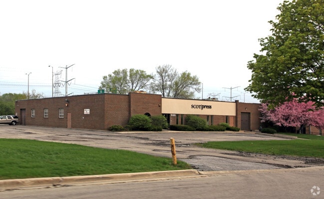
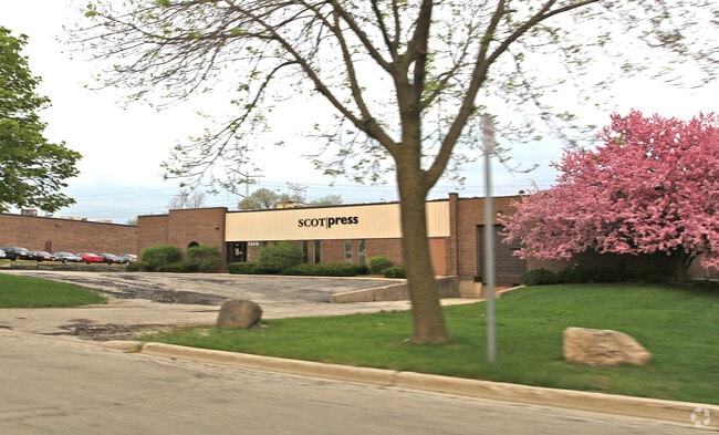
Property Record
5120 Thatcher Rd, Downers Grove, IL 60515


NEARBY LISTINGS FOR SALE OR LEASE
Property Detail
5120 Thatcher Rd
Chicago-Naperville-Elgin, IL-IN-WI
Ellsworth Park
08-11-407-033
ELLSWORTH PARK UNIT 6
Industrialgeneral
DuPage
X
Illinois
17043C0166J
40
2024
0.91 AC
2024
West Suburbs
846002
Chicago
DEMOGRAPHICS near 5120 Thatcher Rd
1 Mile
3 Mile
5 Mile
2024 Total Population
8,206
85,411
259,735
2029 Population
8,111
84,357
256,478
Pop Growth 2024-2029
(1.16%)
(1.23%)
(1.25%)
Average Age
44
42
42
2024 Total Households
3,812
35,732
103,285
HH Growth 2024-2029
(1.15%)
(1.26%)
(1.28%)
Median Household Inc
$87,194
$101,259
$101,612
Avg Household Size
2.10
2.30
2.40
2024 Avg HH Vehicles
2.00
2.00
2.00
Median Home Value
$311,171
$371,293
$386,112
Median Year Built
1972
1976
1977
Nearby Places
Map Layers
Map Styles
 Street
 Aerial
- Restaurants
- Banks
- Shops
- Fitness
- Groceries
PUBLIC TRANSPORTATION
COMMUTER RAIL
Belmont Station (Burlington Northern-Santa Fe Railway Line - Northeast Illinois Regional Commuter Railroad (Metra))
DRIVE
WALK
Distance
Belmont Station (Burlington Northern-Santa Fe Railway Line - Northeast Illinois Regional Commuter Railroad (Metra))
5 min
1.2 mi
Lisle Station (Burlington Northern-Santa Fe Railway Line - Northeast Illinois Regional Commuter Railroad (Metra))
DRIVE
WALK
Distance
Lisle Station (Burlington Northern-Santa Fe Railway Line - Northeast Illinois Regional Commuter Railroad (Metra))
7 min
1.6 mi
AIRPORT
Chicago Midway International
DRIVE
WALK
Distance
Chicago Midway International
37 min
17.7 mi
Chicago O'Hare International
DRIVE
WALK
Distance
Chicago O'Hare International
52 min
22.5 mi
Nearby Properties
Address
Land Use
TOTAL SIZE
Lot Size
Zoning
Address
Land Use
TOTAL SIZE
Lot Size
Zoning
83.99 AC
Address
Land Use
TOTAL SIZE
Lot Size
Zoning
12.96 AC
M
Address
Land Use
TOTAL SIZE
Lot Size
Zoning
534,583 SF
16.04 AC
C
Address
Land Use
TOTAL SIZE
Lot Size
Zoning
8.08 AC
C
Address
Land Use
TOTAL SIZE
Lot Size
Zoning
5.13 AC
M
Address
Land Use
TOTAL SIZE
Lot Size
Zoning
6.03 AC
M
Address
Land Use
TOTAL SIZE
Lot Size
Zoning
20.05 AC
C
Address
Land Use
TOTAL SIZE
Lot Size
Zoning
552,111 SF
4.48 AC
C
Address
Land Use
TOTAL SIZE
Lot Size
Zoning
1.34 AC
Address
Land Use
TOTAL SIZE
Lot Size
Zoning
19.58 AC
C
Address
Land Use
TOTAL SIZE
Lot Size
Zoning
13.53 AC
M
Address
Land Use
TOTAL SIZE
Lot Size
Zoning
2.37 AC
Address
Land Use
TOTAL SIZE
Lot Size
Zoning
13.67 AC
M
Address
Land Use
TOTAL SIZE
Lot Size
Zoning
14.68 AC
I
Address
Land Use
TOTAL SIZE
Lot Size
Zoning
13.89 AC
M
Address
Land Use
TOTAL SIZE
Lot Size
Zoning
19.02 AC
M
Address
Land Use
TOTAL SIZE
Lot Size
Zoning
190,058 SF
11.77 AC
Address
Land Use
TOTAL SIZE
Lot Size
Zoning
8.53 AC
M
Address
Land Use
TOTAL SIZE
Lot Size
Zoning
13.27 AC
M
Address
Land Use
TOTAL SIZE
Lot Size
Zoning
13.44 AC
C
Address
Land Use
TOTAL SIZE
Lot Size
Zoning
291,840 SF
14.34 AC
Address
Land Use
TOTAL SIZE
Lot Size
Zoning
304,995 SF
5.32 AC
C
Address
Land Use
TOTAL SIZE
Lot Size
Zoning
205,315 SF
0.87 AC
Address
Land Use
TOTAL SIZE
Lot Size
Zoning
175,695 SF
1.01 AC
C
Address
Land Use
TOTAL SIZE
Lot Size
Zoning
164,787 SF
8.20 AC
Address
Land Use
TOTAL SIZE
Lot Size
Zoning
25.64 AC
Address
Land Use
TOTAL SIZE
Lot Size
Zoning
213,460 SF
10.71 AC
Address
Land Use
TOTAL SIZE
Lot Size
Zoning
47.33 AC
Address
Land Use
TOTAL SIZE
Lot Size
Zoning
227,600 SF
6.12 AC
C
Address
Land Use
TOTAL SIZE
Lot Size
Zoning
11.87 AC
The World's #1 Commercial Real Estate Marketplace
Connect with us
© 2025 CoStar Group
The information above has been obtained from sources believed reliable. While we do not doubt its accuracy we have not verified it and make no guarantee, warranty or representation about it. It is your responsibility to independently confirm its accuracy and completeness. Any projections, opinions, assumptions, or estimates used are for example only and do not represent the current or future performance of the property. The value of this transaction to you depends on tax and other factors which should be evaluated by your tax, financial, and legal advisors. You and your advisors should conduct a careful, independent investigation of the property to determine to your satisfaction the suitability of the property for your needs.