Property Record
5122 Us Route 5 S, Perkinsville, VT 05151
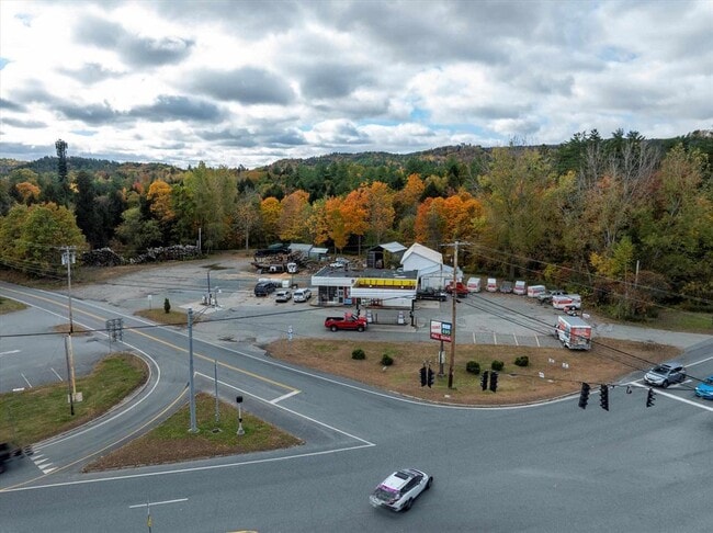


This Property Is For Sale
NEARBY LISTINGS FOR SALE OR LEASE
-
-
View all Perkinsville listings for sale on LoopNet.com
Property Detail
5122 Us Route 5 S
705-224-11482
LAND & BUILDINGS-GAS STATION
Commercialnec
Windsor
X
Vermont
50027C0643E
13.60 AC
2023
Vermont South Area
2024
Other Market Areas
966100
Claremont-Lebanon, NH-VT
DEMOGRAPHICS near 5122 Us Route 5 S
1 Mile
3 Mile
5 Mile
2024 Total Population
336
2,886
17,310
2029 Population
326
2,946
18,141
Pop Growth 2024-2029
(2.98%)
+ 2.08%
+ 4.80%
Average Age
49
46
43
2024 Total Households
153
1,263
7,425
HH Growth 2024-2029
(3.27%)
+ 1.66%
+ 4.54%
Median Household Inc
$68,906
$54,327
$48,993
Avg Household Size
2.10
2.20
2.20
2024 Avg HH Vehicles
2.00
2.00
2.00
Median Home Value
$182,050
$175,382
$168,562
Median Year Built
1970
1966
1962
Nearby Places
Map Layers
Map Styles
 Street
 Aerial
- Restaurants
- Banks
- Shops
- Fitness
- Groceries
PUBLIC TRANSPORTATION
COMMUTER RAIL
Claremont Amtrak (Vermonter - Amtrak)
DRIVE
WALK
Distance
Claremont Amtrak (Vermonter - Amtrak)
7 min
3.8 mi
Windsor-Mt. Ascutney Amtrak (Vermonter - Amtrak)
DRIVE
WALK
Distance
Windsor-Mt. Ascutney Amtrak (Vermonter - Amtrak)
8 min
5.5 mi
Freight Ports
Albany, NY Port
DRIVE
WALK
Distance
Albany, NY Port
168 min
111.1 mi
Nearby Properties
Address
Land Use
TOTAL SIZE
Lot Size
Zoning
Address
Land Use
TOTAL SIZE
Lot Size
Zoning
13.38 AC
Address
Land Use
TOTAL SIZE
Lot Size
Zoning
Address
Land Use
TOTAL SIZE
Lot Size
Zoning
3,304 SF
58 AC
I2
Address
Land Use
TOTAL SIZE
Lot Size
Zoning
5,841 SF
224.10 AC
AR
Address
Land Use
TOTAL SIZE
Lot Size
Zoning
Address
Land Use
TOTAL SIZE
Lot Size
Zoning
4,320 SF
37.49 AC
RR
Address
Land Use
TOTAL SIZE
Lot Size
Zoning
86,164 SF
13.20 AC
I1
Address
Land Use
TOTAL SIZE
Lot Size
Zoning
598.33 AC
Address
Land Use
TOTAL SIZE
Lot Size
Zoning
14.58 AC
RR
Address
Land Use
TOTAL SIZE
Lot Size
Zoning
21.50 AC
Address
Land Use
TOTAL SIZE
Lot Size
Zoning
7,644 SF
5.34 AC
Address
Land Use
TOTAL SIZE
Lot Size
Zoning
3,351 SF
0.86 AC
Address
Land Use
TOTAL SIZE
Lot Size
Zoning
33,340 SF
4.80 AC
I1
Address
Land Use
TOTAL SIZE
Lot Size
Zoning
14.30 AC
RR
Address
Land Use
TOTAL SIZE
Lot Size
Zoning
38,582 SF
12.75 AC
I1
Address
Land Use
TOTAL SIZE
Lot Size
Zoning
10,756 SF
21.59 AC
B2
Address
Land Use
TOTAL SIZE
Lot Size
Zoning
1,485 SF
64 AC
RR
Address
Land Use
TOTAL SIZE
Lot Size
Zoning
3,174 SF
669 AC
AR
Address
Land Use
TOTAL SIZE
Lot Size
Zoning
4,316 SF
5.77 AC
Address
Land Use
TOTAL SIZE
Lot Size
Zoning
Address
Land Use
TOTAL SIZE
Lot Size
Zoning
2,400 SF
3.80 AC
Address
Land Use
TOTAL SIZE
Lot Size
Zoning
25,800 SF
3.30 AC
I1
Address
Land Use
TOTAL SIZE
Lot Size
Zoning
1,000 SF
13.27 AC
I
Address
Land Use
TOTAL SIZE
Lot Size
Zoning
1,653 SF
7.60 AC
Address
Land Use
TOTAL SIZE
Lot Size
Zoning
5,006 SF
6.70 AC
B2
Address
Land Use
TOTAL SIZE
Lot Size
Zoning
2,880 SF
43 AC
RR2
Address
Land Use
TOTAL SIZE
Lot Size
Zoning
3,075 SF
5.90 AC
R1
Address
Land Use
TOTAL SIZE
Lot Size
Zoning
280 SF
2 AC
MD
Address
Land Use
TOTAL SIZE
Lot Size
Zoning
97.90 AC
The World's #1 Commercial Real Estate Marketplace
Connect with us
© 2026 CoStar Group
The information above has been obtained from sources believed reliable. While we do not doubt its accuracy we have not verified it and make no guarantee, warranty or representation about it. It is your responsibility to independently confirm its accuracy and completeness. Any projections, opinions, assumptions, or estimates used are for example only and do not represent the current or future performance of the property. The value of this transaction to you depends on tax and other factors which should be evaluated by your tax, financial, and legal advisors. You and your advisors should conduct a careful, independent investigation of the property to determine to your satisfaction the suitability of the property for your needs.