Property Record
5145 Route 209, Accord, NY 12404
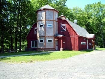
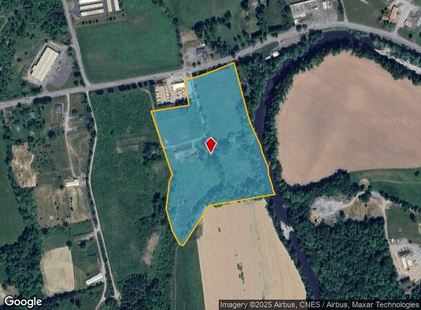
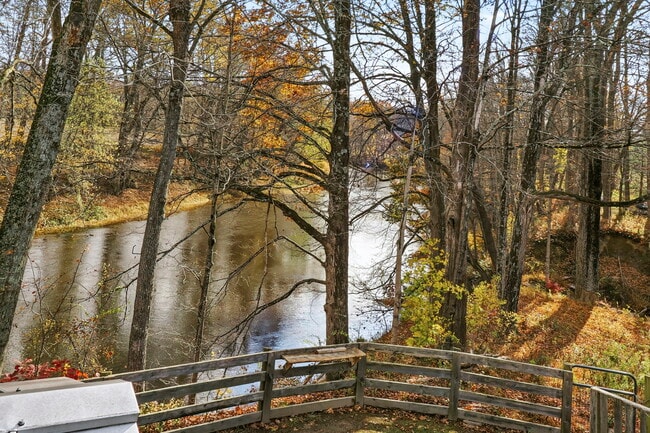
This Property Is For Sale
NEARBY LISTINGS FOR SALE OR LEASE
-
-
View all Accord listings for sale on LoopNet.com
Property Detail
5145 Route 209
Kingston, NY
Subdivision Of Lands Of Melissa Davidson
4400-076.002-0002-026.110-0000
Ulster
Ruralagriculturalresidence
New York
AE
19.30 AC
36111C0590E
Hudson Valley Area
2,552 SF
Other Market Areas
DEMOGRAPHICS near 5145 Route 209
1 Mile
3 Mile
5 Mile
2024 Total Population
515
4,359
9,776
2029 Population
517
4,389
9,872
Pop Growth 2024-2029
+ 0.39%
+ 0.69%
+ 0.98%
Average Age
42
43
44
2024 Total Households
202
1,759
3,720
HH Growth 2024-2029
+ 0.50%
+ 0.68%
+ 1.13%
Median Household Inc
$73,064
$74,931
$73,108
Avg Household Size
2.50
2.40
2.40
2024 Avg HH Vehicles
2.00
2.00
2.00
Median Home Value
$279,999
$304,878
$337,548
Median Year Built
1974
1973
1971
Nearby Places
- Restaurants
- Banks
- Shops
- Fitness
- Groceries
PUBLIC TRANSPORTATION
AIRPORT
New York Stewart International
DRIVE
WALK
Distance
New York Stewart International
59 min
40.2 mi
Freight Ports
Albany, NY Port
DRIVE
WALK
Distance
Albany, NY Port
83 min
68.3 mi
Nearby Properties
Address
Land Use
TOTAL SIZE
Lot Size
Zoning
Address
Land Use
TOTAL SIZE
Lot Size
Zoning
67.16 AC
AR3
Address
Land Use
TOTAL SIZE
Lot Size
Zoning
30 AC
R5
Address
Land Use
TOTAL SIZE
Lot Size
Zoning
Address
Land Use
TOTAL SIZE
Lot Size
Zoning
2,970.01 AC
R5
Address
Land Use
TOTAL SIZE
Lot Size
Zoning
1,500 SF
141.70 AC
AR3
Address
Land Use
TOTAL SIZE
Lot Size
Zoning
34,000 SF
369.80 AC
R5
Address
Land Use
TOTAL SIZE
Lot Size
Zoning
41,876 SF
8 AC
RV15
Address
Land Use
TOTAL SIZE
Lot Size
Zoning
1,352 SF
184.30 AC
R2
Address
Land Use
TOTAL SIZE
Lot Size
Zoning
6,000 SF
5.10 AC
B
Address
Land Use
TOTAL SIZE
Lot Size
Zoning
15,456 SF
62.40 AC
B
Address
Land Use
TOTAL SIZE
Lot Size
Zoning
4,032 SF
63.10 AC
R5
Address
Land Use
TOTAL SIZE
Lot Size
Zoning
5,222 SF
23.20 AC
AR3
Address
Land Use
TOTAL SIZE
Lot Size
Zoning
Address
Land Use
TOTAL SIZE
Lot Size
Zoning
13,224 SF
1.14 AC
H
Address
Land Use
TOTAL SIZE
Lot Size
Zoning
1,911 SF
21.40 AC
R5
Address
Land Use
TOTAL SIZE
Lot Size
Zoning
Address
Land Use
TOTAL SIZE
Lot Size
Zoning
2,634 SF
12.40 AC
R2
Address
Land Use
TOTAL SIZE
Lot Size
Zoning
880 SF
45.60 AC
B
Address
Land Use
TOTAL SIZE
Lot Size
Zoning
12,615 SF
1 AC
IL
Address
Land Use
TOTAL SIZE
Lot Size
Zoning
10,844 SF
33.20 AC
AR3
Address
Land Use
TOTAL SIZE
Lot Size
Zoning
4,655 SF
19.67 AC
R2
Address
Land Use
TOTAL SIZE
Lot Size
Zoning
3,158 SF
13.10 AC
AR3
Address
Land Use
TOTAL SIZE
Lot Size
Zoning
10,106 SF
11.20 AC
AR3
Address
Land Use
TOTAL SIZE
Lot Size
Zoning
Address
Land Use
TOTAL SIZE
Lot Size
Zoning
2,700 SF
19.20 AC
AR3
Address
Land Use
TOTAL SIZE
Lot Size
Zoning
4,500 SF
7.50 AC
AR3
Address
Land Use
TOTAL SIZE
Lot Size
Zoning
8,764 SF
1.43 AC
MU
Address
Land Use
TOTAL SIZE
Lot Size
Zoning
4,372 SF
12.50 AC
AR3
Address
Land Use
TOTAL SIZE
Lot Size
Zoning
30,200 SF
6 AC
B
Address
Land Use
TOTAL SIZE
Lot Size
Zoning
24,287 SF
3 AC
B
The World's #1 Commercial Real Estate Marketplace
Connect with us
© 2025 CoStar Group
The information above has been obtained from sources believed reliable. While we do not doubt its accuracy we have not verified it and make no guarantee, warranty or representation about it. It is your responsibility to independently confirm its accuracy and completeness. Any projections, opinions, assumptions, or estimates used are for example only and do not represent the current or future performance of the property. The value of this transaction to you depends on tax and other factors which should be evaluated by your tax, financial, and legal advisors. You and your advisors should conduct a careful, independent investigation of the property to determine to your satisfaction the suitability of the property for your needs.