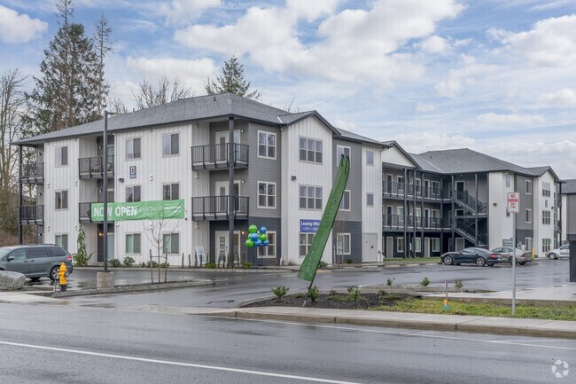
Property Record
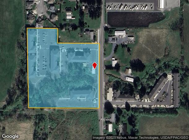
5127 Labounty Rd, Ferndale, WA 98248
NEARBY LISTINGS FOR SALE OR LEASE
-
-
View all Ferndale listings for sale on LoopNet.com
Property Detail
5127 Labounty Rd
390233-232303-0000
SE SE NW-EXC N 121 FT OF E 375 FT-SUBJ TO ESMT REC AF 1206068-LESS RD-EXC PTN TO CITY FOR ST AS DESC AF 2024-0301523
Multifamilydwelling
Whatcom
X
Washington
53073C1180E
8.02 AC
2025
Bellingham/Northwest
2025
Other Market Areas
010503
Bellingham, WA
1,672 SF
DEMOGRAPHICS near 5127 Labounty Rd
1 Mile
3 Mile
5 Mile
2024 Total Population
1,751
14,047
47,401
2029 Population
1,817
14,561
49,515
Pop Growth 2024-2029
+ 3.77%
+ 3.66%
+ 4.46%
Average Age
42
40
40
2024 Total Households
633
5,129
18,962
HH Growth 2024-2029
+ 3.63%
+ 3.49%
+ 4.52%
Median Household Inc
$111,918
$89,201
$68,546
Avg Household Size
2.70
2.70
2.40
2024 Avg HH Vehicles
3.00
2.00
2.00
Median Home Value
$669,708
$533,611
$490,802
Median Year Built
1992
1989
1993
Nearby Places
Map Layers
Map Styles
 Street
 Aerial
- Restaurants
- Banks
- Shops
- Fitness
- Groceries
PUBLIC TRANSPORTATION
AIRPORT
Bellingham International
DRIVE
WALK
Distance
Bellingham International
9 min
4.8 mi
Abbotsford International
DRIVE
WALK
Distance
Abbotsford International
47 min
25.4 mi
Freight Ports
Port of Bellingham, WA
DRIVE
WALK
Distance
Port of Bellingham, WA
14 min
7.8 mi
Nearby Properties
Address
Land Use
TOTAL SIZE
Lot Size
Zoning
Address
Land Use
TOTAL SIZE
Lot Size
Zoning
111,507 SF
845.26 AC
AO
Address
Land Use
TOTAL SIZE
Lot Size
Zoning
260,143 SF
36.13 AC
NC
Address
Land Use
TOTAL SIZE
Lot Size
Zoning
37,698 SF
8.43 AC
GB
Address
Land Use
TOTAL SIZE
Lot Size
Zoning
149,046 SF
AO
Address
Land Use
TOTAL SIZE
Lot Size
Zoning
63,802 SF
8.93 AC
MCD
Address
Land Use
TOTAL SIZE
Lot Size
Zoning
74,027 SF
3.54 AC
RO
Address
Land Use
TOTAL SIZE
Lot Size
Zoning
235,594 SF
56.15 AC
PBI
Address
Land Use
TOTAL SIZE
Lot Size
Zoning
66,344 SF
4.30 AC
RO
Address
Land Use
TOTAL SIZE
Lot Size
Zoning
2,044 SF
6.63 AC
P
Address
Land Use
TOTAL SIZE
Lot Size
Zoning
64,509 SF
4.40 AC
GB
Address
Land Use
TOTAL SIZE
Lot Size
Zoning
156,099 SF
11.44 AC
GB
Address
Land Use
TOTAL SIZE
Lot Size
Zoning
153,557 SF
39.70 AC
PBI
Address
Land Use
TOTAL SIZE
Lot Size
Zoning
140,381 SF
9.76 AC
M
Address
Land Use
TOTAL SIZE
Lot Size
Zoning
7,132 SF
1.40 AC
MCD
Address
Land Use
TOTAL SIZE
Lot Size
Zoning
77,782 SF
5.90 AC
GB
Address
Land Use
TOTAL SIZE
Lot Size
Zoning
82,864 SF
5 AC
R5A
Address
Land Use
TOTAL SIZE
Lot Size
Zoning
49,744 SF
5.92 AC
GB
Address
Land Use
TOTAL SIZE
Lot Size
Zoning
1,536 SF
5 AC
RM1.5
Address
Land Use
TOTAL SIZE
Lot Size
Zoning
48,409 SF
2.24 AC
GB
Address
Land Use
TOTAL SIZE
Lot Size
Zoning
60,880 SF
6.13 AC
LI
Address
Land Use
TOTAL SIZE
Lot Size
Zoning
23,499 SF
4.46 AC
MCD
Address
Land Use
TOTAL SIZE
Lot Size
Zoning
48,728 SF
2.30 AC
RM1.5
Address
Land Use
TOTAL SIZE
Lot Size
Zoning
46,333 SF
2.03 AC
RM1.5
Address
Land Use
TOTAL SIZE
Lot Size
Zoning
56,084 SF
2.75 AC
LI
Address
Land Use
TOTAL SIZE
Lot Size
Zoning
52,100 SF
4.07 AC
GB
Address
Land Use
TOTAL SIZE
Lot Size
Zoning
47,904 SF
5 AC
RCI
Address
Land Use
TOTAL SIZE
Lot Size
Zoning
59,899 SF
2.94 AC
GB
Address
Land Use
TOTAL SIZE
Lot Size
Zoning
64,175 SF
3.03 AC
LI
Address
Land Use
TOTAL SIZE
Lot Size
Zoning
122,762 SF
146.88 AC
R5A
The World's #1 Commercial Real Estate Marketplace
Connect with us
© 2026 CoStar Group
The information above has been obtained from sources believed reliable. While we do not doubt its accuracy we have not verified it and make no guarantee, warranty or representation about it. It is your responsibility to independently confirm its accuracy and completeness. Any projections, opinions, assumptions, or estimates used are for example only and do not represent the current or future performance of the property. The value of this transaction to you depends on tax and other factors which should be evaluated by your tax, financial, and legal advisors. You and your advisors should conduct a careful, independent investigation of the property to determine to your satisfaction the suitability of the property for your needs.