Property Record
513 E Granite Dells Rd, Payson, AZ 85541


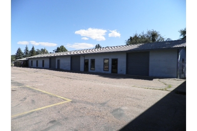

Property Detail
513 E Granite Dells Rd
304-02-005N
SECTION: 03 TOWNSHIP: 10N RANGE: 10E PT SW4 NW4 SEC 3 T10N R10E; COMM SW COR SW4 NE4 SEC 3; TH S 89D 26M 50S E 446.56 TO POB; CONT S 89D 26M 50S E 40.95; TH N 18M 2S E 15; TH S 89D 26M 50S E 49.24; TH N 18M 2S E 354.29 SRLY LN GRANITE DELLS RD; TH N
Vehiclerentalsvehiclesales
Gila
B and X Area of moderate flood hazard, usually the area between the limits of the 100-year and 500-year floods.
Arizona
2025
0.84 AC
2026
Other Market Areas
000500
Payson, AZ
5,792 SF
NEARBY LISTINGS FOR SALE OR LEASE
-
-
View all Payson listings for sale on LoopNet.com
DEMOGRAPHICS near 513 E Granite Dells Rd
1 mile
3 mile
5 mile
2024 Total Population
5,978
18,564
22,371
2029 Population
6,186
19,400
23,450
Pop Growth 2024-2029
+ 3.48%
+ 4.50%
+ 4.82%
Average Age
49
50
50
2024 Total Households
2,729
8,539
10,279
HH Growth 2024-2029
+ 3.30%
+ 4.26%
+ 4.57%
Median Household Inc
$49,168
$56,107
$56,679
Avg Household Size
2.10
2.10
2.10
2024 Avg HH Vehicles
2.00
2.00
2.00
Median Home Value
$271,366
$309,618
$312,928
Median Year Built
1985
1990
1990
Nearby Places
Map Layers
Map Styles
 Street
 Aerial
Transit
 Traffic
 Biking
Places
Listings with unknown addresses are not visible on the map
- Restaurants
- Banks
- Shops
- Fitness
- Groceries
Nearby Properties
Address
Land Use
TOTAL SIZE
Lot Size
Zoning
Address
Land Use
TOTAL SIZE
Lot Size
Zoning
3,834 SF
6.91 AC
Address
Land Use
TOTAL SIZE
Lot Size
Zoning
59.93 AC
Address
Land Use
TOTAL SIZE
Lot Size
Zoning
32,569 SF
4.05 AC
Address
Land Use
TOTAL SIZE
Lot Size
Zoning
152,174 SF
12.28 AC
Address
Land Use
TOTAL SIZE
Lot Size
Zoning
13,043 SF
14.25 AC
Address
Land Use
TOTAL SIZE
Lot Size
Zoning
16,190 SF
94.67 AC
Address
Land Use
TOTAL SIZE
Lot Size
Zoning
104,414 SF
13.94 AC
Address
Land Use
TOTAL SIZE
Lot Size
Zoning
81,297 SF
6.78 AC
Address
Land Use
TOTAL SIZE
Lot Size
Zoning
75,813 SF
5.08 AC
Address
Land Use
TOTAL SIZE
Lot Size
Zoning
30,988 SF
3.19 AC
Address
Land Use
TOTAL SIZE
Lot Size
Zoning
43,476 SF
7.64 AC
Address
Land Use
TOTAL SIZE
Lot Size
Zoning
5,952 SF
7.27 AC
Address
Land Use
TOTAL SIZE
Lot Size
Zoning
80,424 SF
1.89 AC
Address
Land Use
TOTAL SIZE
Lot Size
Zoning
84,594 SF
7.46 AC
Address
Land Use
TOTAL SIZE
Lot Size
Zoning
49,124 SF
2.37 AC
Address
Land Use
TOTAL SIZE
Lot Size
Zoning
2,184 SF
4.69 AC
Address
Land Use
TOTAL SIZE
Lot Size
Zoning
48,800 SF
3.96 AC
Address
Land Use
TOTAL SIZE
Lot Size
Zoning
2,640 SF
32.46 AC
Address
Land Use
TOTAL SIZE
Lot Size
Zoning
66,712 SF
2.68 AC
Address
Land Use
TOTAL SIZE
Lot Size
Zoning
43,687 SF
3.58 AC
Address
Land Use
TOTAL SIZE
Lot Size
Zoning
2,800 SF
0.73 AC
Address
Land Use
TOTAL SIZE
Lot Size
Zoning
20,492 SF
1.99 AC
Address
Land Use
TOTAL SIZE
Lot Size
Zoning
31,560 SF
3.28 AC
Address
Land Use
TOTAL SIZE
Lot Size
Zoning
24,290 SF
7.39 AC
Address
Land Use
TOTAL SIZE
Lot Size
Zoning
75,782 SF
3.69 AC
Address
Land Use
TOTAL SIZE
Lot Size
Zoning
18,419 SF
5.71 AC
Address
Land Use
TOTAL SIZE
Lot Size
Zoning
85,600 SF
2.78 AC
Address
Land Use
TOTAL SIZE
Lot Size
Zoning
61,620 SF
4.77 AC
Address
Land Use
TOTAL SIZE
Lot Size
Zoning
23,476 SF
0.97 AC
Address
Land Use
TOTAL SIZE
Lot Size
Zoning
29,969 SF
2.49 AC
The World's #1 Commercial Real Estate Marketplace
Connect with us
© 2026 CoStar Group
The information above has been obtained from sources believed reliable. While we do not doubt its accuracy we have not verified it and make no guarantee, warranty or representation about it. It is your responsibility to independently confirm its accuracy and completeness. Any projections, opinions, assumptions, or estimates used are for example only and do not represent the current or future performance of the property. The value of this transaction to you depends on tax and other factors which should be evaluated by your tax, financial, and legal advisors. You and your advisors should conduct a careful, independent investigation of the property to determine to your satisfaction the suitability of the property for your needs.