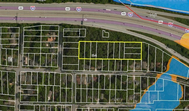
Property Record
320 Grabill Ave, Atlanta, GA 30316

NEARBY LISTINGS FOR SALE OR LEASE
Property Detail
320 Grabill Ave
Atlanta-Sandy Springs-Roswell, GA
Monument Heights Land Co
15-178-04-072
NO PLAT BK/PG
Residentialacreage
DeKalb
X
Georgia
13089C0127J
5
2025
0.17 AC
2025
I-20 East/Conyers
023801
Atlanta
DEMOGRAPHICS near 320 Grabill Ave
1 Mile
3 Mile
5 Mile
2024 Total Population
14,199
142,979
368,258
2029 Population
14,355
146,136
377,292
Pop Growth 2024-2029
+ 1.10%
+ 2.21%
+ 2.45%
Average Age
37
37
37
2024 Total Households
6,851
66,105
165,340
HH Growth 2024-2029
+ 1.04%
+ 2.46%
+ 2.73%
Median Household Inc
$91,154
$95,837
$81,070
Avg Household Size
2.00
2.00
2.00
2024 Avg HH Vehicles
1.00
1.00
1.00
Median Home Value
$445,272
$492,245
$439,659
Median Year Built
1969
1976
1985
Nearby Places
Map Layers
Map Styles
 Street
 Aerial
- Restaurants
- Banks
- Shops
- Fitness
- Groceries
PUBLIC TRANSPORTATION
COMMUTER RAIL
Atlanta (Crescent - Amtrak)
DRIVE
WALK
Distance
Atlanta (Crescent - Amtrak)
12 min
7.7 mi
AIRPORT
Hartsfield - Jackson Atlanta International
DRIVE
WALK
Distance
Hartsfield - Jackson Atlanta International
19 min
12.2 mi
Freight Ports
Georgia Ports - Savannah
DRIVE
WALK
Distance
Georgia Ports - Savannah
279 min
246.2 mi
SALE & LEASE HISTORY
LISTING DATE
SALE/LEASE

Feb 22, 2017
For Sale
Nearby Properties
Address
Land Use
TOTAL SIZE
Lot Size
Zoning
Address
Land Use
TOTAL SIZE
Lot Size
Zoning
2,283,599 SF
12.93 AC
I1
Address
Land Use
TOTAL SIZE
Lot Size
Zoning
3.16 AC
SPI1
Address
Land Use
TOTAL SIZE
Lot Size
Zoning
1,300,309 SF
4.81 AC
SPI1
Address
Land Use
TOTAL SIZE
Lot Size
Zoning
467,847 SF
1.62 AC
I2
Address
Land Use
TOTAL SIZE
Lot Size
Zoning
1,121,700 SF
2.21 AC
I2
Address
Land Use
TOTAL SIZE
Lot Size
Zoning
0.91 AC
I1
Address
Land Use
TOTAL SIZE
Lot Size
Zoning
736,752 SF
3.86 AC
C1
Address
Land Use
TOTAL SIZE
Lot Size
Zoning
543,748 SF
3.86 AC
I2
Address
Land Use
TOTAL SIZE
Lot Size
Zoning
1,975,400 SF
9.58 AC
RG4
Address
Land Use
TOTAL SIZE
Lot Size
Zoning
432,056 SF
17.87 AC
C1
Address
Land Use
TOTAL SIZE
Lot Size
Zoning
510,561 SF
87 SF
SPI1
Address
Land Use
TOTAL SIZE
Lot Size
Zoning
400,311 SF
4.45 AC
I2
Address
Land Use
TOTAL SIZE
Lot Size
Zoning
327,098 SF
4.92 AC
X
Address
Land Use
TOTAL SIZE
Lot Size
Zoning
398,215 SF
3.19 AC
C1
Address
Land Use
TOTAL SIZE
Lot Size
Zoning
595,658 SF
4.09 AC
I1
Address
Land Use
TOTAL SIZE
Lot Size
Zoning
959,348 SF
7.28 AC
PDMU
Address
Land Use
TOTAL SIZE
Lot Size
Zoning
548,615 SF
4.52 AC
I1
Address
Land Use
TOTAL SIZE
Lot Size
Zoning
543,551 SF
5.26 AC
R4
Address
Land Use
TOTAL SIZE
Lot Size
Zoning
529,576 SF
1.47 AC
SPI1
Address
Land Use
TOTAL SIZE
Lot Size
Zoning
94.93 AC
R5
Address
Land Use
TOTAL SIZE
Lot Size
Zoning
756,921 SF
0.16 AC
C4
Address
Land Use
TOTAL SIZE
Lot Size
Zoning
290,130 SF
6.13 AC
R100
Address
Land Use
TOTAL SIZE
Lot Size
Zoning
397,758 SF
1.91 AC
I1
Address
Land Use
TOTAL SIZE
Lot Size
Zoning
11,036 SF
0.62 AC
SPI1
Address
Land Use
TOTAL SIZE
Lot Size
Zoning
495,740 SF
2.65 AC
C1
Address
Land Use
TOTAL SIZE
Lot Size
Zoning
566,872 SF
3.31 AC
I1
Address
Land Use
TOTAL SIZE
Lot Size
Zoning
369,356 SF
2.50 AC
I1
Address
Land Use
TOTAL SIZE
Lot Size
Zoning
67,882 SF
4.77 AC
X
Address
Land Use
TOTAL SIZE
Lot Size
Zoning
491,862 SF
2.44 AC
R4
Address
Land Use
TOTAL SIZE
Lot Size
Zoning
528,810 SF
3.61 AC
I2
The World's #1 Commercial Real Estate Marketplace
Connect with us
© 2025 CoStar Group
The information above has been obtained from sources believed reliable. While we do not doubt its accuracy we have not verified it and make no guarantee, warranty or representation about it. It is your responsibility to independently confirm its accuracy and completeness. Any projections, opinions, assumptions, or estimates used are for example only and do not represent the current or future performance of the property. The value of this transaction to you depends on tax and other factors which should be evaluated by your tax, financial, and legal advisors. You and your advisors should conduct a careful, independent investigation of the property to determine to your satisfaction the suitability of the property for your needs.